Mappt: GIS Data Collection
In-app purchases
3.4star
278 reviews
50K+
Downloads

Everyone
info


About this app
Mappt™ is a powerful GIS (Geographic Information System) data collection app that allows users to create, edit, store and share location-based data with one light, compact device.
Mappt™ is used in industries spanning from environmental and agriculture, to mining and local government in over 130 countries worldwide.
They choose Mappt™ because it integrates with popular desktop GIS including ArcGIS and QGIS, and the user friendly interface hosts easy to use features that even those new to field data collection will master in minutes, including:
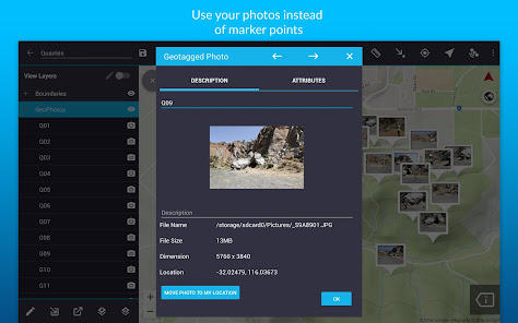
- Geotagged photos to give your important data a far more visual element than just a marker point
- Drop down forms for faster data collection
- Offline GPS tracking
- On-screen annotation tools to draw, add text and create shapes over your data
- Read and download a full suite of WMS/WFS & WMTS datasets
- Points, polygons and polylines
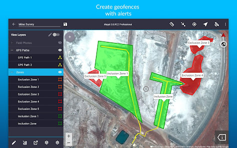
- Geofencing capabilities make sure you never breach a boundary
- Overlay coordinate grids see the exact distance between areas
- Street view mode with on-screen annotations available
- Import unlimited sized satellite, aerial, geological, topographic, elevation and other types of imagery in ECW and JP2 format
- Import and export popular GIS formats such as Shapefiles, JP2 and KML/KMZ
- Share your data between popular cloud storage such as Google Drive
Our clients have used our offline GIS app for a range of in-field tasks including:
- Field mapping
- Land surveying
- Vegetation management
- Forestry planning
- Environmental management
- Incident reporting
- Mine management
- Farm mapping
- Utility mapping
- Government planning
- Asset management
Leave internet worries, bulky equipment and inaccurate data in the past, and experience a more efficient future of data collection with Mappt™.
***NOTE: You are free to trial Mappt™ for 120 minutes. Once this time is up, you can either wait 8 hours for another 120 minutes, or purchase a monthly licence from US$29 to unlock full functionality. For more information about features and licensing tiers, please visit www.mappt.com.au/pricing.***
Mappt™ is used in industries spanning from environmental and agriculture, to mining and local government in over 130 countries worldwide.
They choose Mappt™ because it integrates with popular desktop GIS including ArcGIS and QGIS, and the user friendly interface hosts easy to use features that even those new to field data collection will master in minutes, including:
- Geotagged photos to give your important data a far more visual element than just a marker point
- Drop down forms for faster data collection
- Offline GPS tracking
- On-screen annotation tools to draw, add text and create shapes over your data
- Read and download a full suite of WMS/WFS & WMTS datasets
- Points, polygons and polylines
- Geofencing capabilities make sure you never breach a boundary
- Overlay coordinate grids see the exact distance between areas
- Street view mode with on-screen annotations available
- Import unlimited sized satellite, aerial, geological, topographic, elevation and other types of imagery in ECW and JP2 format
- Import and export popular GIS formats such as Shapefiles, JP2 and KML/KMZ
- Share your data between popular cloud storage such as Google Drive
Our clients have used our offline GIS app for a range of in-field tasks including:
- Field mapping
- Land surveying
- Vegetation management
- Forestry planning
- Environmental management
- Incident reporting
- Mine management
- Farm mapping
- Utility mapping
- Government planning
- Asset management
Leave internet worries, bulky equipment and inaccurate data in the past, and experience a more efficient future of data collection with Mappt™.
***NOTE: You are free to trial Mappt™ for 120 minutes. Once this time is up, you can either wait 8 hours for another 120 minutes, or purchase a monthly licence from US$29 to unlock full functionality. For more information about features and licensing tiers, please visit www.mappt.com.au/pricing.***
Updated on
Safety starts with understanding how developers collect and share your data. Data privacy and security practices may vary based on your use, region, and age. The developer provided this information and may update it over time.

No data shared with third parties
Learn more about how developers declare sharing

This app may collect these data types
Personal info, App activity and 2 others

Data is encrypted in transit

You can request that data be deleted
Ratings and reviews
3.2
238 reviews

A Google user
- Flag inappropriate
September 23, 2019
Everything works perfect, but adding a default value for each field would make the job much easier because this kind of usage usually requires changing values of 1 or 2 fields, every orher is pretty much the same so, making it posible to store a default value would make this app 5/5. Great work - keep it up :)
21 people found this review helpful
A Google user
- Flag inappropriate
January 24, 2020
The Mappt app was offered to me at a special "first-year" discount of just $19 as a member of The Geological Society of America. So naturally, I expected the app could be a powerful geologic tool in the field. As it turned out, the geology features were disabled, and the only way to use the geologic tools I needed to purchase the $400+ version. It felt like a bate-and-switch. Why provide at a supposedly discounted trial rate through a Geo Society if the geo tools didn't work! Not happy!
26 people found this review helpful

Petrus Hurter (Johan)
- Flag inappropriate
May 27, 2023
Uncontactable - used to be good and contactable - now completely useless. You can not even get a contact page on line. It seems as if it has been left to generate money from those stupid enough to buy it and left those who bought it years ago in the lurch!
4 people found this review helpful
What's new
- Improved Security: We've updated our app's security to protect your user license keys.
- New Feature: Now you can add detailed SOAR maps to your projects!
- Clearer EULA: We've made the End User License Agreement (EULA) easier to understand.
- Fixed Android Access: You can now access your media files properly, even on the latest Android versions.
- Other minor bug fixes and improvements
