
BRouter Offline Navigation
3.7star
1.34K reviews
100K+
Downloads

Everyone
info

About this app
Configurable, elevation-aware (bike-) Router for OFFLINE Navigation based on open data. Works in conjunction with a Map Application.
See http://brouter.de/brouter for more documenation
See http://brouter.de/brouter-web for an online version.
*** If you do not know one of the supporting map applications, then the BRouter-App is useless for you. Download only if you are willing to spend some time to understand the setup. No one-star reviews from the unpatient please! email for problems ***
BRouter does only the plain route-calculation and does not display a map or the calculated route on it's own and therefore works only together with a Map Application. There are two different methods for the interfacing between BRouter and the Map application: BRouter offers a service interface that is called by the map application without a need to start the BRouter-App. This way, BRouter is a routing service very much like an online routing service, including dynamic recalculations if you get off the track. The other mode of operation is to start the BRouter-App and use waypoints from the map application's waypoint database to define your route. The calculated route is then written as a GPX file (including the elevation profile) to the map-application's tracks directory.
Some popular map apps support both the service interface and the interface via the wayoint database in their current versions available on Google Play.
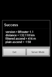
The service interface uses a timeout of 60s, limiting it's use to distances of about 50km, but using the BRouter App you are able to calculate much longer distances. But even long-distance tracks can be followed via the service interface (including dynamic recalculations). This is done by pre-calculating a route for your destination once using the BRouter App and assigning it to a routing mode via the "Server-Mode" Button. This feature is called "timeout-free recalculations".
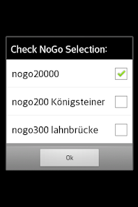
The route calculation, no matter if via the service interface or via the BRouter App, also considers nogo areas that can be defined as waypoints with a special naming convention (e.g. "nogo200" for 200m radius). This way it is possible to account for actual obstacles, but this feature can also be used to enforce personal preferences.
BRouter contains a download manager that assists downloading the required routing data files.The download manager is called on the first start of the app, and later on it is offered if internet access is available.
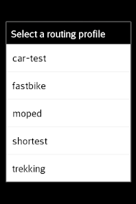
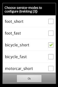
The mapping from one of the 6 routing modes (car/bike/foot * fast/short), that are used traditionally by routing services, and BRouter's concept of fully configurable routing profiles get's the following default mapping after the installation of BRouter:
car-fast -> car-test
car-short -> moped
bike-fast -> fastbike
bike-short -> trekking
foot-fast -> shortest
foot-short -> shortest
This mapping, however, can by changed anytime via the "Server-Mode" Button of the BRouter App. But also the routing profile definitions can be changed or new ones can be created.
Routing for cars is is currently available only in an experimental state ("car-test") and is not recommend. For example, turn-restriction are not taken into account.
See http://brouter.de/brouter for more documenation
See http://brouter.de/brouter-web for an online version.
*** If you do not know one of the supporting map applications, then the BRouter-App is useless for you. Download only if you are willing to spend some time to understand the setup. No one-star reviews from the unpatient please! email for problems ***
BRouter does only the plain route-calculation and does not display a map or the calculated route on it's own and therefore works only together with a Map Application. There are two different methods for the interfacing between BRouter and the Map application: BRouter offers a service interface that is called by the map application without a need to start the BRouter-App. This way, BRouter is a routing service very much like an online routing service, including dynamic recalculations if you get off the track. The other mode of operation is to start the BRouter-App and use waypoints from the map application's waypoint database to define your route. The calculated route is then written as a GPX file (including the elevation profile) to the map-application's tracks directory.
Some popular map apps support both the service interface and the interface via the wayoint database in their current versions available on Google Play.
The service interface uses a timeout of 60s, limiting it's use to distances of about 50km, but using the BRouter App you are able to calculate much longer distances. But even long-distance tracks can be followed via the service interface (including dynamic recalculations). This is done by pre-calculating a route for your destination once using the BRouter App and assigning it to a routing mode via the "Server-Mode" Button. This feature is called "timeout-free recalculations".
The route calculation, no matter if via the service interface or via the BRouter App, also considers nogo areas that can be defined as waypoints with a special naming convention (e.g. "nogo200" for 200m radius). This way it is possible to account for actual obstacles, but this feature can also be used to enforce personal preferences.
BRouter contains a download manager that assists downloading the required routing data files.The download manager is called on the first start of the app, and later on it is offered if internet access is available.
The mapping from one of the 6 routing modes (car/bike/foot * fast/short), that are used traditionally by routing services, and BRouter's concept of fully configurable routing profiles get's the following default mapping after the installation of BRouter:
car-fast -> car-test
car-short -> moped
bike-fast -> fastbike
bike-short -> trekking
foot-fast -> shortest
foot-short -> shortest
This mapping, however, can by changed anytime via the "Server-Mode" Button of the BRouter App. But also the routing profile definitions can be changed or new ones can be created.
Routing for cars is is currently available only in an experimental state ("car-test") and is not recommend. For example, turn-restriction are not taken into account.
Updated on
Safety starts with understanding how developers collect and share your data. Data privacy and security practices may vary based on your use, region, and age. The developer provided this information and may update it over time.

No data shared with third parties
Learn more about how developers declare sharing

No data collected
Learn more about how developers declare collection
Ratings and reviews
3.7
1.22K reviews

Jan DL1JPH
- Flag inappropriate
March 21, 2023
If you're able to read and follow some simple instructions, this works perfectly. The UI feels quite dated, but that's not really an issue once everything is set up. I've very rarely had issues getting OsmAnd to connect to the service, though, which required a reboot of the phone to sort out.

Leo Trance
- Flag inappropriate
June 11, 2021
I like how I can customize the routing. Unfortunately, I forgot to grab my custom profile and it's rather excruciating to really fine tune. I had the perfect blend of using high quality bike paths to street paths while minimizing distance and elevations, and I've never had another profile do that. Took me DAYs to perfect that. Sigh... Still highly recommended!
11 people found this review helpful

J Dekker
- Flag inappropriate
October 18, 2022
I use Brouter as add on with maptool Alpine Quest. Altough that means Brouter is not used to the full extent (nogo areas and rerouting non existent to Alpine Quest) the two apps together are totaly brilliant. Brouter is easy to understand with the right maptool. It is highly functional when hiking and biking or traveling being offline and wanting to create a route from A to B. Having that on board is so handy. Find a good maptool that can use Brouter then the use of Brouter is a no brainer.
1 person found this review helpful
What's new
BRouter translations
fallback on certificate problems
fallback on certificate problems


