
JagdGR
In-app purchases
1K+
Downloads

Everyone
info

About this app
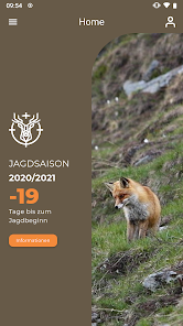
JagdGR the Application Grisons hunters.
A feature-rich app and provides satellite maps (online) and topographic maps (in receiving poor or empfagnslosen zones).
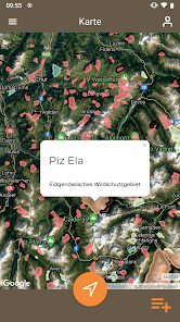
In addition, it shows with precision the point where you are and also whether there are wildlife sanctuaries nearby. For this you can also control the sector in which you are.
It also provides a great help for the firings in 3 quota. With a simple graph the different combinations are displayed. If one emphasizes the already killed animals, the app is even from what can still be shot. Last but not least, JagdGR can be a good help for the official hunting statistics: village, local name, sector number, H.ü.M., date, time, GPS coordinates (Switzerland) are displayed.
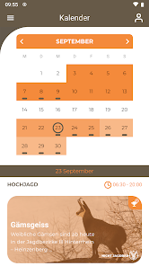
Another useful feature is the various hunting periods and shot times (high and low hunting) and the huntable species in the selected periods. For this you always have the current hunting operating rules and the telephone numbers of the gamekeeper and the Schweisshünde in his pocket.
A feature-rich app and provides satellite maps (online) and topographic maps (in receiving poor or empfagnslosen zones).
In addition, it shows with precision the point where you are and also whether there are wildlife sanctuaries nearby. For this you can also control the sector in which you are.
It also provides a great help for the firings in 3 quota. With a simple graph the different combinations are displayed. If one emphasizes the already killed animals, the app is even from what can still be shot. Last but not least, JagdGR can be a good help for the official hunting statistics: village, local name, sector number, H.ü.M., date, time, GPS coordinates (Switzerland) are displayed.
Another useful feature is the various hunting periods and shot times (high and low hunting) and the huntable species in the selected periods. For this you always have the current hunting operating rules and the telephone numbers of the gamekeeper and the Schweisshünde in his pocket.
Updated on
Safety starts with understanding how developers collect and share your data. Data privacy and security practices may vary based on your use, region, and age. The developer provided this information and may update it over time.

No data shared with third parties
Learn more about how developers declare sharing

This app may collect these data types
Location, Personal info, and Photos and videos

Data is encrypted in transit

You can request that data be deleted
What's new
August 2023 Release mit den folgenden Neuigkeiten
- Bug behoben, der eine automatische Aktualisierung der Kartenebenen nicht zuliess
- Fleischuntersuchung, aktualisiertes PDF hinzugefügt
- FAQ-Menü in den Einstellungen und Konto hinzugefügt
- Bug beim Herunterladen der lokalen Karte behoben
- Verschiedene andere Bugs behoben
- Bug behoben, der eine automatische Aktualisierung der Kartenebenen nicht zuliess
- Fleischuntersuchung, aktualisiertes PDF hinzugefügt
- FAQ-Menü in den Einstellungen und Konto hinzugefügt
- Bug beim Herunterladen der lokalen Karte behoben
- Verschiedene andere Bugs behoben