
Andmap ULTIMATE
4.3star
13 reviews
1K+
Downloads

Everyone
info


About this app
Andmap - Field Mapping, Data Collection and Online Project Management
Core Features:
• Work offline - no internet connection required
• Real-time sync capability when internet available
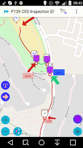
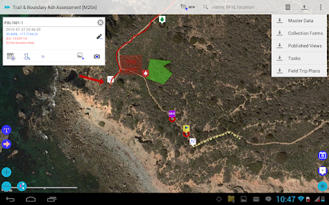
• Mapping, collect data rich points, lines, polygons, and custom overlay - text or image
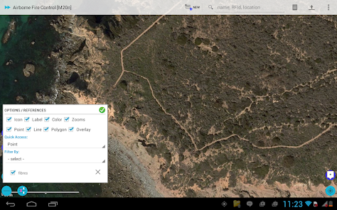
• Control color / style of polyline, polygon by attribute data
• Control icon of point, polyline, and polygon by attribute data
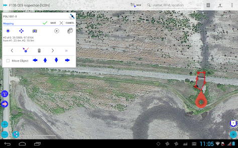
• Move whole object, or individual point
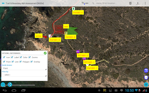
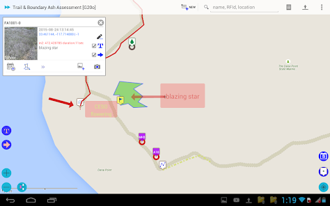
• Map annotation - Label / Arrow, Image Overlay - Crop photo
• Divide Polyline at a point
• Make copy of object
• KML / KMZ viewer
• Dynamic create Label image for KMZ image overlay
• Integration with 3rd party annotation tool
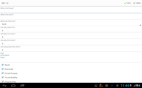
• Customize Data Collection Forms - attribute data
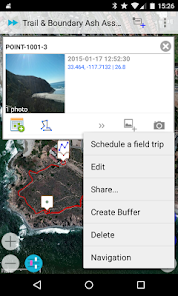
• Geo-tagged photo integrate with compass
• Task Management - see detail: http://blog.andmap.co/task-management-2/
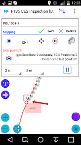
• Position Averaging - calculating an average coordinate
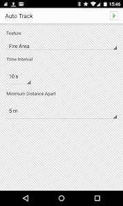
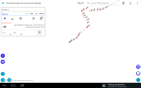
• Auto Track - Auto record point, line, or polygon
• Offline Maps: Streetmap / topo or imagery base map
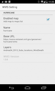
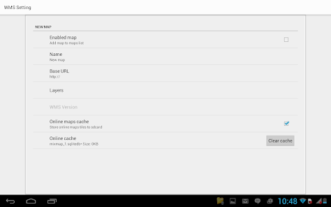
• WMS Viewer - Web Map Service
• Create Offline Maps directly from your device
• Share data in KMZ to cloud server, Dropbox, Google Drive...
• Import KMZ - images, icons, custom overlay, map annotation and attribute data
• Review | Edit | Export your data online
• Interface to your GIS - Shapefile, KML, KMZ, CSV, and GPX
• Daily work log
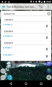
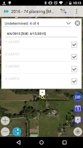
• Field trip planning - Schedule
• Task Management
• 0.1 meter accuracy in mapping
Targeted at GPS/GIS mapping professionals in industries such as Telecom, Oil / Gas, Forestry, Utility, Agriculture, Environmental and other natural resource industries in addition to local, state and federal government users.
Templates:
• CES Inspection
• Groundwater Monitoring
• Predictive vegetation mapping
• Soil Sampling
• Routine Wetland Determination
• Archaeological Survey
• Vehicle Inspection
• Waste Inventory Tracking
• Utility Pole
• Sediment Sampling
• Stream Side BIO Survey
• Pipeline Marker
• Well Inspection
• Home Inspection
• Well Inspection
• Pipeline Inspection
• Property Inspection
• Sewer / Manhole Assessment / Inspection
Benefits:
• Improved data quality and provide more complete data.
• Improved efficiency and minimized site revisits.
• Improved interface to the GIS.
• Will facilitate the collection of more data more quickly and thus increasing the usefulness of the GIS.
• Easier to use user interface that requires less training.
Core Features:
• Work offline - no internet connection required
• Real-time sync capability when internet available
• Mapping, collect data rich points, lines, polygons, and custom overlay - text or image
• Control color / style of polyline, polygon by attribute data
• Control icon of point, polyline, and polygon by attribute data
• Move whole object, or individual point
• Map annotation - Label / Arrow, Image Overlay - Crop photo
• Divide Polyline at a point
• Make copy of object
• KML / KMZ viewer
• Dynamic create Label image for KMZ image overlay
• Integration with 3rd party annotation tool
• Customize Data Collection Forms - attribute data
• Geo-tagged photo integrate with compass
• Task Management - see detail: http://blog.andmap.co/task-management-2/
• Position Averaging - calculating an average coordinate
• Auto Track - Auto record point, line, or polygon
• Offline Maps: Streetmap / topo or imagery base map
• WMS Viewer - Web Map Service
• Create Offline Maps directly from your device
• Share data in KMZ to cloud server, Dropbox, Google Drive...
• Import KMZ - images, icons, custom overlay, map annotation and attribute data
• Review | Edit | Export your data online
• Interface to your GIS - Shapefile, KML, KMZ, CSV, and GPX
• Daily work log
• Field trip planning - Schedule
• Task Management
• 0.1 meter accuracy in mapping
Targeted at GPS/GIS mapping professionals in industries such as Telecom, Oil / Gas, Forestry, Utility, Agriculture, Environmental and other natural resource industries in addition to local, state and federal government users.
Templates:
• CES Inspection
• Groundwater Monitoring
• Predictive vegetation mapping
• Soil Sampling
• Routine Wetland Determination
• Archaeological Survey
• Vehicle Inspection
• Waste Inventory Tracking
• Utility Pole
• Sediment Sampling
• Stream Side BIO Survey
• Pipeline Marker
• Well Inspection
• Home Inspection
• Well Inspection
• Pipeline Inspection
• Property Inspection
• Sewer / Manhole Assessment / Inspection
Benefits:
• Improved data quality and provide more complete data.
• Improved efficiency and minimized site revisits.
• Improved interface to the GIS.
• Will facilitate the collection of more data more quickly and thus increasing the usefulness of the GIS.
• Easier to use user interface that requires less training.
Updated on
Data safety
Developers can show information here about how their app collects and uses your data. Learn more about data safety

No information available
Ratings and reviews
4.2
8 reviews

A Google user
- Flag inappropriate
June 17, 2015
Very well supported app. The developer will adapt to fit your needs and is more than willing to accept input. The only smartphone app that I have found that can effectively replace GIS specific (expensive) equipment and do so effectively. I look forward to seeing Andmap continue to advance. Thanks!
3 people found this review helpful
A Google user
- Flag inappropriate
August 28, 2014
Seems promising, but this is only a two week trial, not enough time to figure out how to use, let alone evaluate.
ANDMAP LLC
September 2, 2014
Extend trial period up to 1 month, Thank you very much for trying.
A Google user
- Flag inappropriate
July 19, 2014
Just have done Wetland Delineation project using Andmap. Simple and easy, bluetooth GPS receiver works very well, no much modification when data upload, save to shapefile, then all the field work is done. Have to say Very useful app, save a lot of time.
What's new
Fixes: Permission
New Map Source: Landscape Map
Customized Pipeline
filtering data
Custom Icons
Map Annotation
Push Notification
Dynamic custom map icon
KML / KMZ viewer
Add / Replace saved location
Large data - KMZ import
Map Annotation
Create Image for Overlay
Custom Overlay - Text or Image on top of Map
Position Averaging
Line Style, Line Width, Z-Order
Improved Moving Point
Field Trip Planning
Task Management
Conditional Forms
Geo-tagged photos in mapping mode
Auto Track


