
Symi Guide
Contains ads
100+
Downloads

Everyone
info


About this app
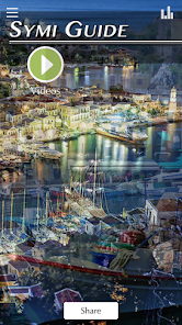
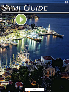
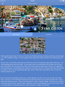
While approaching the port of Symi, one has the overwhelming feeling of entering a perfectly painted image of a scenic traditional village. As a rule, people remain agape and cannot take their eyes off the spectacular sight.
The few who can resist the superb spectacle of the town of Symi stretching its impeccable architecture – all of the buildings there have been listed - on the slopes of the surrounding hills, take off their eyes to look at their book guides. They see the picture of the port of Symi printed on their books. They know it might have been photoshoped; in all likelihood, they expected it to be better than the real thing. Still, when they lift their eyes again to marvel at the breathtaking sight, they realise it belies their expectations: Symi is more than words or photos can say!
Symi is located in the Southern Dodecanese, north of Rhodes and close to the coast of south-west Turkey. Symi is just over 13 km northsouth and about 8 km eastwest with an area of some 68 square km. Symi is divided into distinctive areas - Yialos is the main harbour. Chorio, literally 'village', is the top town. Pedi Bay is the valley below Chorio, south of Yialos. Nimborios is the bay and settlement to the north of Yialos. There is a small settlement at Marathounda and a major Monastery complex at Panormitis.
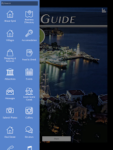
With the Symi Guide App you can:
-Locate local businesses
-Get Directions
-Keep up to date with local events
-Find useful numbers
-Check the weatehr
Plus much much more.
The few who can resist the superb spectacle of the town of Symi stretching its impeccable architecture – all of the buildings there have been listed - on the slopes of the surrounding hills, take off their eyes to look at their book guides. They see the picture of the port of Symi printed on their books. They know it might have been photoshoped; in all likelihood, they expected it to be better than the real thing. Still, when they lift their eyes again to marvel at the breathtaking sight, they realise it belies their expectations: Symi is more than words or photos can say!
Symi is located in the Southern Dodecanese, north of Rhodes and close to the coast of south-west Turkey. Symi is just over 13 km northsouth and about 8 km eastwest with an area of some 68 square km. Symi is divided into distinctive areas - Yialos is the main harbour. Chorio, literally 'village', is the top town. Pedi Bay is the valley below Chorio, south of Yialos. Nimborios is the bay and settlement to the north of Yialos. There is a small settlement at Marathounda and a major Monastery complex at Panormitis.
With the Symi Guide App you can:
-Locate local businesses
-Get Directions
-Keep up to date with local events
-Find useful numbers
-Check the weatehr
Plus much much more.
Updated on
Data safety
Developers can show information here about how their app collects and uses your data. Learn more about data safety

No information available
What's new
Minor Fixes


