
Horizon Explorer AR

4.0star
279 reviews
50K+
Downloads

Everyone
info


About this app
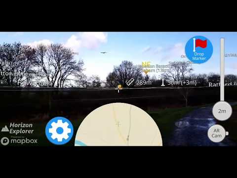
Point your camera at a landmark you can see on the horizon (eg. Mountain peak, Road, Lake, Building, Airplane) and see:
- Name of the landmark
- Distance from you
- Altitude (& relative to you)
- Map of surrounding area
- Nearby towns and cities
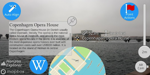
- Wikipedia info for any landmark with a Wikipedia page
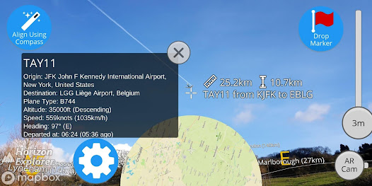
- Altitude, destination, flight number, airspeed of any commercial airline plane
- Directions to landmark (opens in google maps)
- Street view for where you're pointing (opens in google maps)
Or use 3D Map mode:
- See terrain and hills laid out in front of you
- Move phone to fly around the map
- Roadmap / satellite / hybrid
- Search & display 3D-maps for anywhere worldwide
- Distance, altitude and landmark names
- Markers on hill & mountain peaks
- Infinite scroll
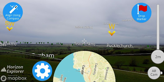
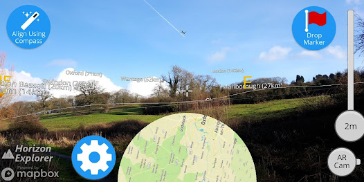
Horizon Explorer works worldwide, but works best on top of a hill with an unobstructed view of your surroundings. You can drag the horizon line with your finger to line up with the camera if the automatic tracking is not working very well. Or try waving your phone around in the air in a figure 8, then press "align using compass" to calibrate the compass.
Live airplanes: Enable planes from the settings menu, then point at a plane to see the flight number, origin, destination, altitude and current airspeed of any commercial airline plane you can see.
If you are in a tall building, or otherwise not standing on the ground, enable "Tall Building mode" and optionally set your altitude using the slider.
Horizon Explorer will show mountain & hill peak names, lakes or forests, the names & designations of roads, and many buildings.
Wikipedia Information will be displayed for anything that has a Wikipedia article with a location set on the article.
- Name of the landmark
- Distance from you
- Altitude (& relative to you)
- Map of surrounding area
- Nearby towns and cities
- Wikipedia info for any landmark with a Wikipedia page
- Altitude, destination, flight number, airspeed of any commercial airline plane
- Directions to landmark (opens in google maps)
- Street view for where you're pointing (opens in google maps)
Or use 3D Map mode:
- See terrain and hills laid out in front of you
- Move phone to fly around the map
- Roadmap / satellite / hybrid
- Search & display 3D-maps for anywhere worldwide
- Distance, altitude and landmark names
- Markers on hill & mountain peaks
- Infinite scroll
Horizon Explorer works worldwide, but works best on top of a hill with an unobstructed view of your surroundings. You can drag the horizon line with your finger to line up with the camera if the automatic tracking is not working very well. Or try waving your phone around in the air in a figure 8, then press "align using compass" to calibrate the compass.
Live airplanes: Enable planes from the settings menu, then point at a plane to see the flight number, origin, destination, altitude and current airspeed of any commercial airline plane you can see.
If you are in a tall building, or otherwise not standing on the ground, enable "Tall Building mode" and optionally set your altitude using the slider.
Horizon Explorer will show mountain & hill peak names, lakes or forests, the names & designations of roads, and many buildings.
Wikipedia Information will be displayed for anything that has a Wikipedia article with a location set on the article.
Updated on
Data safety
Developers can show information here about how their app collects and uses your data. Learn more about data safety

No information available
Ratings and reviews
4.0
278 reviews

Matt O'Neill
- Flag inappropriate
- Show review history
April 2, 2024
Sadly, it doesn't seem to work on the S24 Ultra out of the box. "Google Play Services for AR" needs to be installed or it will just crash. After that it's nice, I do wish the location data was a bit more detailed, for instance including the names of smaller streams and hills. Not at all needed but it would be niffy.

Eric Miller
- Flag inappropriate
August 13, 2022
Powerful but a mess. Text is either too tiny or too big. Text collides with other text. AR topographic map that appears when zooming should just take over the screen instead of partially overlaying the camera image because the two aren't compatible. There could be a toggle or transparency slider instead. A find feature might be nice. I was looking for a peak which should have been in view but couldn't find it.
3 people found this review helpful

A Google user
- Flag inappropriate
- Show review history
September 16, 2018
Difficult to use. Display on screen does not match the images in the description. The description shows the word distance and the word altitude. I see something like a ruler laying at a 45 degree angle that might indicate distance and there's some kind of vertical bar that might indicate altitude. but the distance is definitely wrong I pointed at a house across the street that's a hundred fifty feet away and its reporting less than 70. there is a half circle at the bottom of the screen that I have no idea what it's supposed to do. There's also a yellow blotch that sort of floats around on the screen but no description of what it's supposed to do sometimes a strawberry like red icon pops up and floats around I have no idea what that indicates.
10 people found this review helpful
Arrow Software Development
October 31, 2018
You're right those are distance and altitude. Try pointing at something on the horizon and the distance will be more accurate.
It's much more useful when you have a view of the horizon. Try it somewhere with a decent view (on a hill) and you'll find it works a lot better.
We've added a tutorial - hopefully it explains how it works.
What's new
- Fix bug where camera fails to connect / black screen on start.
- Upgrade ARCore SDK to 1.14.0.
- Fix bug where wikipedia pane didn't always disappear when pointing away from the marker for short articles.
- Improve performance when first pointing at Wikipedia marker.
- Upgrade ARCore SDK to 1.14.0.
- Fix bug where wikipedia pane didn't always disappear when pointing away from the marker for short articles.
- Improve performance when first pointing at Wikipedia marker.