
Russian Topo Maps Pro
4.8star
7.45K reviews
50K+
Downloads

Everyone
info


About this app
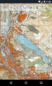
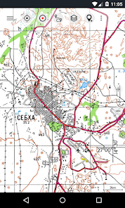
Offroad/Offline Navigation App with worldwide topographic maps (mainly Russian General Staff). For many countries in Africa and Asia these maps still belong to the best available topomaps.
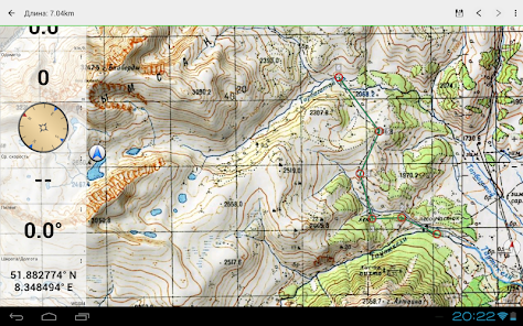
Available map layers:
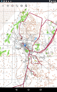
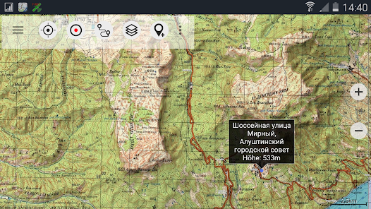
• Topomaps worldwide (100K-200K worldwide seamless coverage)
• Google Maps (Satellite images, Road- and Terrain-Map)
• ROSREESTR The Federal Service for State Registration, Cadastre and Cartography
• Open Street Maps (OSM Mapnik, Osmarender and Cloudemade Cyclemap)
• Bing Maps
• Hillshading Overlay Layer
• ESRI
This app gives you similar mapping options as you might know from Garmin or Magellan GPS handhelds.
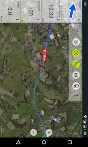
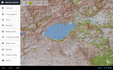
Main features for Outdoor-Navigation:
• Bulk-download of map tiles for OFFLINE USAGE (not for Google maps)
• Create and edit Waypoints
• Create and navigate Routes
• GoTo-Waypoint-Navigation
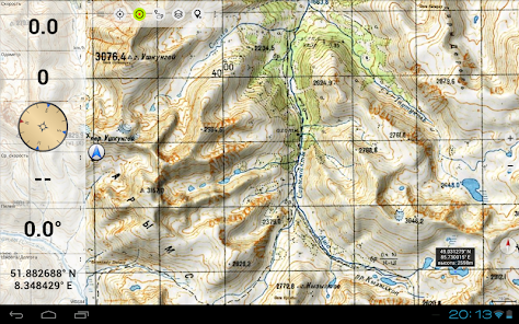
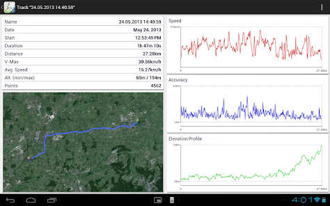
• Track Recording (with speed and elevation profile)
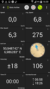
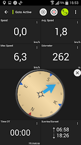
• Tripmaster with fields for odometer, average speed, bearing, elevation, etc.
• GPX-Import / Export, KML-Export
• Search (placenames, POIs, streets)
• Customizable datafields in Map View and Tripmaster (e.g. Speed, Distance, Compass, ...)
• Waypoint-/Track-Sharing (via eMail, Facebook, ..)
• Import Oziexplorer raster map in with OZF2 OZFX3 extension
• Import OpenStreetMaps in vector format (less storage needed)
• and many more ...
Soviet Military Maps is the perfect moving map app for offroad trips, adventure travels and expeditions. You are planning cross country trips to Sahara desert or a trekking tour to the Himalayas ? With the Russian topos you have always a great alternative to other map sources. Beneath the good topography the maps include many small trails and unpaved roads that are missing in other map sets.
The Russian maps have additional English labels.
Attention: The Soviet Military Maps were created mainly in the 80ies and are less interesting for industrialized countries. Outside Africa and Asia you'll find the OSM / Google map layers more useful.
Please note: This app does not provide direct "Turn-by-Turn" navigation - but with a selected waypoint you can easily switch to Google Navigation.
Please contact us if you have any questions, feature requests or bug reports regarding this app: android@atlogis.com
Map coverage:
Scale 1:100.000 :
Europe, Afghanistan, Azerbaijan, Georgia, Japan, Jordan, Latvia, Lithuania, Kazakhstan, Kyrgyzstan, Morocco, Mongolia, Pakistan, Russia, Syria, Tajikistan, Turkey, Turkmenistan, Ukraine, Uzbekistan, Belarus
Scale 1:200.000 :
Afghanistan, Egypt, Algeria, Angola, Argentina, Armenia, Azerbaijan, Bahrain, Bangladesh, Belarus, Benin, Bhutan, Bolivia, Botswana, British Virgin Islands, Bulgaria, Burkina Faso, Burma, Cambodia, Cameroon, Central African Republic, Chad, Chile, China, Comoros, Ivory Coast, Cuba, Cyprus, Czech Republic, DR Congo (part), Djibouti, Eritrea, Estonia, Ethiopia, Falkland Islands, Finland, Gambia, Georgia, Ghana, Guinea, Guinea-Bissau, Iceland, India, Indonesia, Iran, Iraq, Israel, Jamaica, Jordan, Kazakhstan, Kenya (part), Kuwait, Kyrgyzstan, Laos, Latvia, Lebanon, Lesotho, Liberia, Libya, Lithuania, Madagascar, Malawi, Malaysia, Mali, Mauritania, Moldova, Mongolia , Morocco, Mozambique, Namibia, Nepal, Niger, Nigeria, North Korea, Oman, Pakistan, Philippines, Qatar, Romania, Russia, Saudi Arabia, Senegal, Sierra Leone, Singapore, Slovakia, Somalia, South Africa, South Korea, Spain, Sri Lanka , Sudan, Svalbard, Swaziland, Sweden, Syria, Taiwan, Tajikistan, Tanzania (part), Thailand, The Gambia, Togo, Tunisia, Turkey, Turkmenistan, Ukraine, United Arab Emirates, Uzbekistan, Vietnam, Western Sahara, Yemen, Zambia, Zimbabwe
Scale 1:250.000 (Local maps from USGS, Geoscience Australia, CTIO ):
USA, Canada, Australia
Scale 1:500.000:
All other countries
Available map layers:
• Topomaps worldwide (100K-200K worldwide seamless coverage)
• Google Maps (Satellite images, Road- and Terrain-Map)
• ROSREESTR The Federal Service for State Registration, Cadastre and Cartography
• Open Street Maps (OSM Mapnik, Osmarender and Cloudemade Cyclemap)
• Bing Maps
• Hillshading Overlay Layer
• ESRI
This app gives you similar mapping options as you might know from Garmin or Magellan GPS handhelds.
Main features for Outdoor-Navigation:
• Bulk-download of map tiles for OFFLINE USAGE (not for Google maps)
• Create and edit Waypoints
• Create and navigate Routes
• GoTo-Waypoint-Navigation
• Track Recording (with speed and elevation profile)
• Tripmaster with fields for odometer, average speed, bearing, elevation, etc.
• GPX-Import / Export, KML-Export
• Search (placenames, POIs, streets)
• Customizable datafields in Map View and Tripmaster (e.g. Speed, Distance, Compass, ...)
• Waypoint-/Track-Sharing (via eMail, Facebook, ..)
• Import Oziexplorer raster map in with OZF2 OZFX3 extension
• Import OpenStreetMaps in vector format (less storage needed)
• and many more ...
Soviet Military Maps is the perfect moving map app for offroad trips, adventure travels and expeditions. You are planning cross country trips to Sahara desert or a trekking tour to the Himalayas ? With the Russian topos you have always a great alternative to other map sources. Beneath the good topography the maps include many small trails and unpaved roads that are missing in other map sets.
The Russian maps have additional English labels.
Attention: The Soviet Military Maps were created mainly in the 80ies and are less interesting for industrialized countries. Outside Africa and Asia you'll find the OSM / Google map layers more useful.
Please note: This app does not provide direct "Turn-by-Turn" navigation - but with a selected waypoint you can easily switch to Google Navigation.
Please contact us if you have any questions, feature requests or bug reports regarding this app: android@atlogis.com
Map coverage:
Scale 1:100.000 :
Europe, Afghanistan, Azerbaijan, Georgia, Japan, Jordan, Latvia, Lithuania, Kazakhstan, Kyrgyzstan, Morocco, Mongolia, Pakistan, Russia, Syria, Tajikistan, Turkey, Turkmenistan, Ukraine, Uzbekistan, Belarus
Scale 1:200.000 :
Afghanistan, Egypt, Algeria, Angola, Argentina, Armenia, Azerbaijan, Bahrain, Bangladesh, Belarus, Benin, Bhutan, Bolivia, Botswana, British Virgin Islands, Bulgaria, Burkina Faso, Burma, Cambodia, Cameroon, Central African Republic, Chad, Chile, China, Comoros, Ivory Coast, Cuba, Cyprus, Czech Republic, DR Congo (part), Djibouti, Eritrea, Estonia, Ethiopia, Falkland Islands, Finland, Gambia, Georgia, Ghana, Guinea, Guinea-Bissau, Iceland, India, Indonesia, Iran, Iraq, Israel, Jamaica, Jordan, Kazakhstan, Kenya (part), Kuwait, Kyrgyzstan, Laos, Latvia, Lebanon, Lesotho, Liberia, Libya, Lithuania, Madagascar, Malawi, Malaysia, Mali, Mauritania, Moldova, Mongolia , Morocco, Mozambique, Namibia, Nepal, Niger, Nigeria, North Korea, Oman, Pakistan, Philippines, Qatar, Romania, Russia, Saudi Arabia, Senegal, Sierra Leone, Singapore, Slovakia, Somalia, South Africa, South Korea, Spain, Sri Lanka , Sudan, Svalbard, Swaziland, Sweden, Syria, Taiwan, Tajikistan, Tanzania (part), Thailand, The Gambia, Togo, Tunisia, Turkey, Turkmenistan, Ukraine, United Arab Emirates, Uzbekistan, Vietnam, Western Sahara, Yemen, Zambia, Zimbabwe
Scale 1:250.000 (Local maps from USGS, Geoscience Australia, CTIO ):
USA, Canada, Australia
Scale 1:500.000:
All other countries
Updated on
Safety starts with understanding how developers collect and share your data. Data privacy and security practices may vary based on your use, region, and age. The developer provided this information and may update it over time.

No data shared with third parties
Learn more about how developers declare sharing

No data collected
Learn more about how developers declare collection

Data is encrypted in transit
Ratings and reviews
4.8
6.78K reviews

John Venkov
- Flag inappropriate
November 7, 2023
best all in one topographical and general map that allows you to download all kinds of maps and overlays with them at the zoom level you want. can't recommend it enough!
19 people found this review helpful

Unaligned Coder
- Flag inappropriate
February 1, 2024
Unfortunately location doesn't work at all. Keeps placing me in the Moscow area even though I am in Almaty. Says it took it from the network, which can't be. Besides GPS in the phone works fine, permission is allowed, so there is a basic problem with the app.
6 people found this review helpful

Alexander Nikitin
- Flag inappropriate
October 3, 2021
I am using it for my backpacking trips in Siberia for a number of years. It is very useful for navigating in unknown areas especially if you did not prepare a trip plan in advance and have no GPS cooddinates for key points. Just do not forget to download maps for the area of interest.
74 people found this review helpful
What's new
・Fixes


