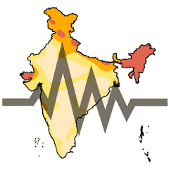
Earthquake Hazard Map of India
4.4star
28 reviews
5K+
Downloads

Everyone
info

About this app
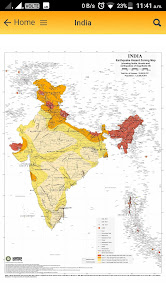
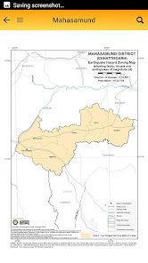
National Disaster Management Authority (NDMA) jointly with BMTPC have prepared the Earthquake Hazard Zoning maps of India as a whole, every State and UT of the country and each district, taking the details up to the sub-district namely, Tehsil, Talukas, Blocks, etc. based on IS 1893(Part 1):2002.
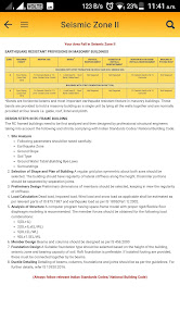
The latest Seismic Zone Map of India denotes that about 59 percent of India’s land area is vulnerable to moderate to severe seismic hazard i.e. prone to shaking of MSK intensity VII and above. In the recent past, most Indian cities have witnessed the phenomenal growth of multi-storied buildings, super malls, luxury apartments and social infrastructure as a part of the process of development. The rapid expansion of the built environment in moderate or high-risk cities makes it imperative to incorporate seismic risk reduction strategies in various aspects of urban planning and construction of new structures.
The necessity to disseminate information regarding hazard proneness at district level has been felt by experts time and to provide necessarily a tool to District Disaster Management Authorities for planning of the Earthquake Disaster Reduction, based on Indian Standard Code IS 1893:2002 Criteria for Earthquake Resistant Design of Structures, Part 1 General Provisions and Buildings (Fifth Revision) and using the Vulnerability Atlas of India (2006), brought out by Building Materials and Technology Promotion Council (BMTPC), Ministry of Housing & Urban Poverty Alleviation, GOI which provides earthquake hazard maps in digitized form upto State level in 1:2 million scale.
These outputs will be useful for Code Committees, architects and engineers, insurance agencies, people involved in land use planning, and, in various aspects of public and financial policies dealing with disaster mitigation and emergency planning and management.
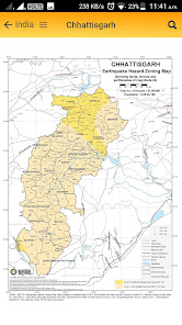
This information can be used by every citizen of the country by looking at the District Hazard Zoning Map to know in which intensity zone his/her village is and then to approach the knowledgeable authorities for guidance about his/her safety from a future earthquake occurrence in the area.
The latest Seismic Zone Map of India denotes that about 59 percent of India’s land area is vulnerable to moderate to severe seismic hazard i.e. prone to shaking of MSK intensity VII and above. In the recent past, most Indian cities have witnessed the phenomenal growth of multi-storied buildings, super malls, luxury apartments and social infrastructure as a part of the process of development. The rapid expansion of the built environment in moderate or high-risk cities makes it imperative to incorporate seismic risk reduction strategies in various aspects of urban planning and construction of new structures.
The necessity to disseminate information regarding hazard proneness at district level has been felt by experts time and to provide necessarily a tool to District Disaster Management Authorities for planning of the Earthquake Disaster Reduction, based on Indian Standard Code IS 1893:2002 Criteria for Earthquake Resistant Design of Structures, Part 1 General Provisions and Buildings (Fifth Revision) and using the Vulnerability Atlas of India (2006), brought out by Building Materials and Technology Promotion Council (BMTPC), Ministry of Housing & Urban Poverty Alleviation, GOI which provides earthquake hazard maps in digitized form upto State level in 1:2 million scale.
These outputs will be useful for Code Committees, architects and engineers, insurance agencies, people involved in land use planning, and, in various aspects of public and financial policies dealing with disaster mitigation and emergency planning and management.
This information can be used by every citizen of the country by looking at the District Hazard Zoning Map to know in which intensity zone his/her village is and then to approach the knowledgeable authorities for guidance about his/her safety from a future earthquake occurrence in the area.
Updated on
Data safety
Developers can show information here about how their app collects and uses your data. Learn more about data safety

No information available
Ratings and reviews
4.4
28 reviews

Hari Kumar
- Flag inappropriate
November 25, 2020
Really really useful app. I hope we can have similar maps for other hazards. Thanks.
2 people found this review helpful

story lover
- Flag inappropriate
June 4, 2020
very very useful...I like this app so much...This app help me so much and family ..thanks
3 people found this review helpful

Ddd Dkk
- Flag inappropriate
November 12, 2022
please add "hindi language" & other Indian languages
1 person found this review helpful