
CarryMap
3.3star
1.09K reviews
100K+
Downloads

Everyone
info


About this app
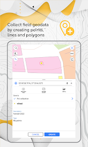
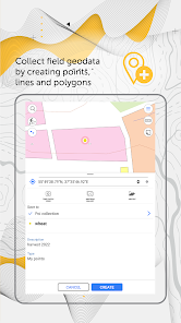
Collect field data, add and edit point, line, and polygon features on your mobile map, share your data with peers.
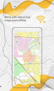
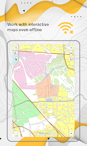
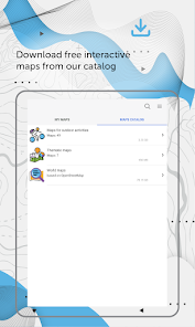
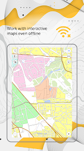
Access your maps everywhere you go, all app features are available even offline. CarryMap provides seamless field work without authorization, payments and in-app purchases. With the app you can use maps prepared in ArcGIS or download free maps covering various territories from our catalog. The maps provided in the catalog were created based on OpenStreetMap data.
1. Work in the app without authorization, payments and in-app purchases.
2. Add your own maps or download free maps from our catalog.
3. Create and edit point, line, and polygon features on map.
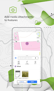
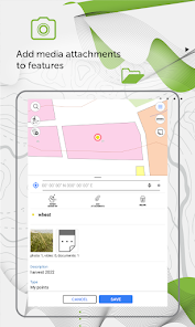
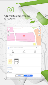
4. Add media attachments (photo, video and documents) to features.
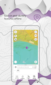
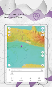
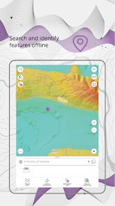
5. Search and identify features offline.
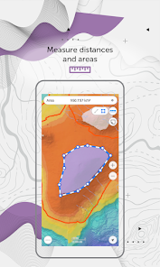
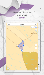
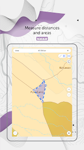
6. Measure distances and areas.
7. Create points on-the-fly using your device camera.
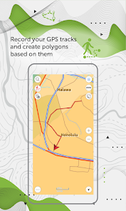
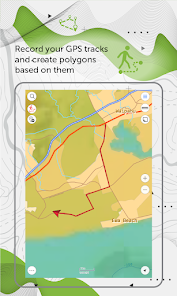
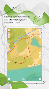
8. Record your GPS tracks and create polygons based on them
9. Add graphic marks in the form of text, arrows or free hand graphic to the mobile map.
10. Use external Bad Elf GPS receiver to find your current location.
11. Save selected map areas as bookmarks for quicker access.
12. Use map features as landmarks or destination points.
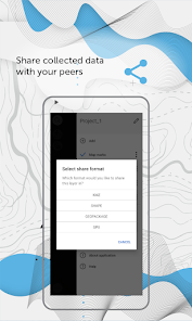
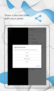
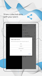
13. Share collected data in GPKG, GPX, KML/KMZ and SHP formats.
Specialists from electrical energy industry, agriculture, geology and geodesy, housing and utility, water and land resources management, ecology and incident management, urban management, and other areas worldwide successfully use CarryMap app for working with maps and solving their everyday job tasks.
CarryMap app is provided for work with maps of specific mobile format CMF2. To export your ArcGIS maps to this format, you will need CarryMap Builder – an extension to ArcGIS Desktop. Visit https://builder.carrymap.com/ to learn more about CarryMap Builder.
To learn more about CarryMap application, visit https://carrymap.com.
Your questions or comments are welcome at support@xtools.pro.
Subscribe to our Facebook page at https://www.facebook.com/carrymap/.
Subscribe to our YouTube channel at https://www.youtube.com/c/CarryMap/videos.
Access your maps everywhere you go, all app features are available even offline. CarryMap provides seamless field work without authorization, payments and in-app purchases. With the app you can use maps prepared in ArcGIS or download free maps covering various territories from our catalog. The maps provided in the catalog were created based on OpenStreetMap data.
1. Work in the app without authorization, payments and in-app purchases.
2. Add your own maps or download free maps from our catalog.
3. Create and edit point, line, and polygon features on map.
4. Add media attachments (photo, video and documents) to features.
5. Search and identify features offline.
6. Measure distances and areas.
7. Create points on-the-fly using your device camera.
8. Record your GPS tracks and create polygons based on them
9. Add graphic marks in the form of text, arrows or free hand graphic to the mobile map.
10. Use external Bad Elf GPS receiver to find your current location.
11. Save selected map areas as bookmarks for quicker access.
12. Use map features as landmarks or destination points.
13. Share collected data in GPKG, GPX, KML/KMZ and SHP formats.
Specialists from electrical energy industry, agriculture, geology and geodesy, housing and utility, water and land resources management, ecology and incident management, urban management, and other areas worldwide successfully use CarryMap app for working with maps and solving their everyday job tasks.
CarryMap app is provided for work with maps of specific mobile format CMF2. To export your ArcGIS maps to this format, you will need CarryMap Builder – an extension to ArcGIS Desktop. Visit https://builder.carrymap.com/ to learn more about CarryMap Builder.
To learn more about CarryMap application, visit https://carrymap.com.
Your questions or comments are welcome at support@xtools.pro.
Subscribe to our Facebook page at https://www.facebook.com/carrymap/.
Subscribe to our YouTube channel at https://www.youtube.com/c/CarryMap/videos.
Updated on
Safety starts with understanding how developers collect and share your data. Data privacy and security practices may vary based on your use, region, and age. The developer provided this information and may update it over time.

No data shared with third parties
Learn more about how developers declare sharing

No data collected
Learn more about how developers declare collection
Ratings and reviews
3.2
1.06K reviews

A Google user
- Flag inappropriate
- Show review history
April 26, 2019
The maps abilities are great, it can be used for many things. The down side is the way it leads you to your marker. Absolutely horrible, just a compass that constantly points toward your marker. This needs to change, it needs to track roads, I'm not a bird I can't fly over fields and forests. When changed, 5 stars.
26 people found this review helpful
A Google user
- Flag inappropriate
March 11, 2020
Everytime I open the program it will not allow me to use it without allowing access to my location. It wouldn't be bad thing if I didn't already know what I was looking for and didn't need my location showed. This is VERY ANNOYING, it will not just like me check something without having it on. It is only on mobile phones. Tablets don't do this so why does it bother me everytime you want to use GPS location. You say "No Thanks" and it just pops right back up! Denying permission doesn't work....
17 people found this review helpful
XTools Pro
March 13, 2020
Dear Corey Albers! Thank you for your feedback. We know about this bug and the next release we will fixed it.

Ambrosia Joy
- Flag inappropriate
January 25, 2021
Map arbitrary stops recording and loses data and mapped tracks, gets two stars instead of one because it worked phenomenal up until October of 2020, now it's junk without any actual details on the map anymore either. Also sometimes records part of a track and skips huge parts of it, also loses pinpoints.
17 people found this review helpful
XTools Pro
February 3, 2021
Please, contact us at support@dataeast.com and describe in detail your problem.
What's new
• New option to work with raster maps in MBTiles format.
• New ability to record and save voice comments (audio attachments) when creating and describing features on the map.
• New option to set and view Z coordinates of point features.
• New option to view information about traveled distance when moving to the destination point.
• Automatic creation of a point based on the user's location.
App support
About the developer
XTools Pro , Inc
dev@xtools.pro
333 W Maude Ave Ste 207
Sunnyvale, CA 94085
United States
+1 669-290-9014


