
Polaris GPS Navigation
Contains adsIn-app purchases
4.5star
43.7K reviews
1M+
Downloads

Everyone
info


About this app
Easy-to-use high performance GPS for wherever your travels take you. No account setup or subscriptions required.
Turn your phone into a powerful GPS navigation system with Polaris Navigation GPS, the most accurate all-purpose GPS, and dare to go where there are no roads.
Imagine... What would it be like to navigate any waterway or hike any wilderness or city using only your phone's GPS location abilities and a view of the sky? What it would be like to create navigation destinations without the need of an internet connection and find them using offline maps or a waypoint pointing arrow.
That is just a glimpse of the navigational power you will hold in your hands when you install Polaris Navigation GPS.
Used mostly as a hiking, off road, nautical and trail GPS app, Polaris is an excellent backup or replacement for your dedicated GPS satellite navigation unit and will keep you oriented wherever your outdoor adventures take you!
Typical usage:
● Waypoint navigation.
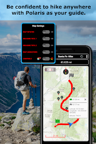
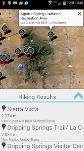
● Hiking GPS with the best hiking maps! Search and find nearby trails.
● Back country exploration and outdoor adventure.
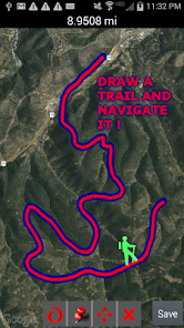
● Record tracks and navigate trails.
● Offroad navigation support for your ATV, Jeep or other 4x4 vehicle.
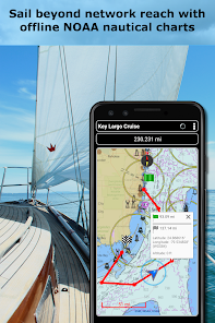
● Sailing / Boating. All marine navigation charts in Polaris are free.
● Fishing GPS. Easily find you favorite fishing hole.
● Hunting and hunting maps. Find you favorite hunting blind and your way back!
● Geocache
● Camping
● Mountain Biking and bike maps
● Backpacking and other outdoor sports
● Compass orienteering
Known for its stability, reliability and flexibility, Polaris is used by land-sea search and rescue, military personnel and millions of others worldwide.
For your offline adventures we provide:
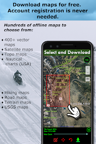
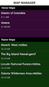
📡 Unlimited free access to our offline vector & raster maps (topographic maps, marine, hiking and others).
📡 Offline nautical charts for the USA included (ENC's and raster).
This powerful navigation system also includes:
📡 Polaris Places Picker. Find hiking trails, camping locations and much more!
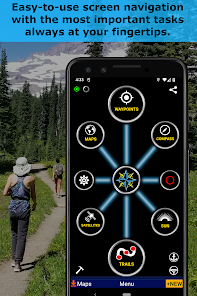
📡 GPS compass and magnetic compass.
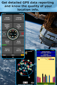
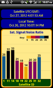
📡 GPS info panel.
📡 Odometers, altimeters, speedometers, chronometers.
📡 Split distances on tracks.
📡 Connect your waypoints and navigate the track they define.
Map Types:
- Google Maps
- OpenStreetMap-Mapnik
- Topographic Maps
- Cycle Route and Hiking Maps
- Vector Maps
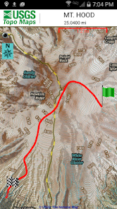
- USGS Topo
- NOAA Marine Charts
- Aviation Operations Charts
- Canada Toporama
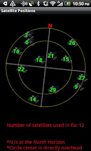
📡 Comprehensive set of GPS Tools and diagnostics.
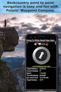
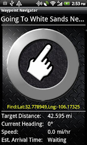
📡 Waypoint navigation system including a dynamic waypoint-finding compass that always points to your destination while reporting estimated time of arrival, distance to target and other statistics. Just follow the arrow!
📡 Trail navigation system
📡 Altitude profiles
📡 Location sharing
📡 Supports British OSGR and OSGB-36 DATUM (Ordnance Survey Grid).
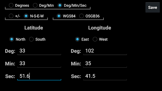
📡 Coordinate formats: latitude/longitude as degrees, deg:min, deg:min:sec, and UTM (Universal Transverse Mercator)
📡 Military Coordinate Finder - Military Grid Coordinate Reference System (MGRS)
📡 Hiking Trails - Most of the maps show hiking paths courtesy of the Openstreetmap project. You will find that even some of the most remote hiking routes are visible on our maps.
⚓ Marine navigation- NOAA Nautical Charts and nautical unit reporting.
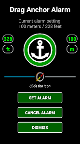
⚓ Drift alert / Drag anchor alarm.
📡 Select source for altitude reporting: Satellites, United States Geologic Survey or map your location to the results of NASA's Space Shuttle Radar Topography Mission.
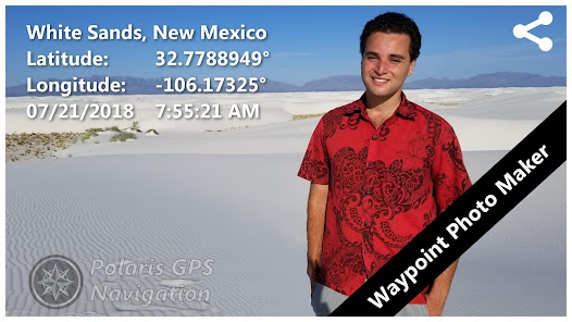
📡 Waypoint photos stamped with coordinates.
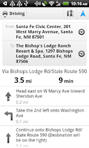
📡 Road navigation and street directions are provided through a digital pipeline connecting the power of Polaris to the Google Maps app on your device.
* The premium version of Polaris Navigation is called GPS Waypoints Navigator, available on Google Play. GPS Waypoints Navigator is ad-free and contains many other enhancements.
Turn your phone into a powerful GPS navigation system with Polaris Navigation GPS, the most accurate all-purpose GPS, and dare to go where there are no roads.
Imagine... What would it be like to navigate any waterway or hike any wilderness or city using only your phone's GPS location abilities and a view of the sky? What it would be like to create navigation destinations without the need of an internet connection and find them using offline maps or a waypoint pointing arrow.
That is just a glimpse of the navigational power you will hold in your hands when you install Polaris Navigation GPS.
Used mostly as a hiking, off road, nautical and trail GPS app, Polaris is an excellent backup or replacement for your dedicated GPS satellite navigation unit and will keep you oriented wherever your outdoor adventures take you!
Typical usage:
● Waypoint navigation.
● Hiking GPS with the best hiking maps! Search and find nearby trails.
● Back country exploration and outdoor adventure.
● Record tracks and navigate trails.
● Offroad navigation support for your ATV, Jeep or other 4x4 vehicle.
● Sailing / Boating. All marine navigation charts in Polaris are free.
● Fishing GPS. Easily find you favorite fishing hole.
● Hunting and hunting maps. Find you favorite hunting blind and your way back!
● Geocache
● Camping
● Mountain Biking and bike maps
● Backpacking and other outdoor sports
● Compass orienteering
Known for its stability, reliability and flexibility, Polaris is used by land-sea search and rescue, military personnel and millions of others worldwide.
For your offline adventures we provide:
📡 Unlimited free access to our offline vector & raster maps (topographic maps, marine, hiking and others).
📡 Offline nautical charts for the USA included (ENC's and raster).
This powerful navigation system also includes:
📡 Polaris Places Picker. Find hiking trails, camping locations and much more!
📡 GPS compass and magnetic compass.
📡 GPS info panel.
📡 Odometers, altimeters, speedometers, chronometers.
📡 Split distances on tracks.
📡 Connect your waypoints and navigate the track they define.
Map Types:
- Google Maps
- OpenStreetMap-Mapnik
- Topographic Maps
- Cycle Route and Hiking Maps
- Vector Maps
- USGS Topo
- NOAA Marine Charts
- Aviation Operations Charts
- Canada Toporama
📡 Comprehensive set of GPS Tools and diagnostics.
📡 Waypoint navigation system including a dynamic waypoint-finding compass that always points to your destination while reporting estimated time of arrival, distance to target and other statistics. Just follow the arrow!
📡 Trail navigation system
📡 Altitude profiles
📡 Location sharing
📡 Supports British OSGR and OSGB-36 DATUM (Ordnance Survey Grid).
📡 Coordinate formats: latitude/longitude as degrees, deg:min, deg:min:sec, and UTM (Universal Transverse Mercator)
📡 Military Coordinate Finder - Military Grid Coordinate Reference System (MGRS)
📡 Hiking Trails - Most of the maps show hiking paths courtesy of the Openstreetmap project. You will find that even some of the most remote hiking routes are visible on our maps.
⚓ Marine navigation- NOAA Nautical Charts and nautical unit reporting.
⚓ Drift alert / Drag anchor alarm.
📡 Select source for altitude reporting: Satellites, United States Geologic Survey or map your location to the results of NASA's Space Shuttle Radar Topography Mission.
📡 Waypoint photos stamped with coordinates.
📡 Road navigation and street directions are provided through a digital pipeline connecting the power of Polaris to the Google Maps app on your device.
* The premium version of Polaris Navigation is called GPS Waypoints Navigator, available on Google Play. GPS Waypoints Navigator is ad-free and contains many other enhancements.
Updated on
Safety starts with understanding how developers collect and share your data. Data privacy and security practices may vary based on your use, region, and age. The developer provided this information and may update it over time.


Ratings and reviews
4.5
41.4K reviews

Mike Kdot
- Flag inappropriate
- Show review history
April 17, 2024
Enjoyed and recommended for years, but will not work on my Asus Zenfone 11 ultra running android 14 stock. Only the right side displays properly. I get longitude, true heading, altitude, speed, time, and the compass in the middle works too. It will not load directions only a route preview. I still gave it 4 stars, because it works well on other devices.
Disciple Skies Software
April 18, 2024
Thanks for the feedback, Mike. If you could please send a couple of screenshots showing the problem on Asus Zenfone we will try to fix it. Our email is support@discipleskies.com

R. Louis T.
- Flag inappropriate
February 8, 2021
Not like a real GPS device. You can record a track (trail) but you cannot navigate a track? Have used it only for hiking so no idea how it works for driving. The waypoints functionality is good, and it's nice to see waypoints and tracks on satellite images. But the basic hiking functionality of following a recorded track seems to be missing.
8 people found this review helpful
Disciple Skies Software
February 9, 2021
Of course you can navigate a track. Tap the track on you trail list, select "Map Trail". Start walking outdoors and the map will come to life showing a directional location marker which is updated every 2 seconds. Refer to the marker, the trail tracing and the other map cues to stay on the trail. Email questions to support@discipleskies.com

Mark C
- Flag inappropriate
July 26, 2020
A bit clunky, but has a wealth of features. It’s okay for free, but you can only save 3 routes at a time. Possibly if purchased it unlocks more features. Doesn’t seem to keep a time on your routes which I would have liked and only has elevation and plotting. The good is there are lots of map vectors which is very cool. But, I’m still looking
75 people found this review helpful
What's new
1. Find hiking and bike trails in your area or around any location.


