
Avare

4.8star
6.3K reviews
100K+
Downloads

Everyone
info


About this app
** Not a Map app - Aviation Only. **
** Aviation U.S. FAA materials and more. **
** No support in Reviews. **
** Please use our Friendly, helpful Support Forum. **
24/7 at: https://groups.google.com/forum/#!forum/apps4av-forum
**NOTE: Avare can't function fully until you turn on BOTH
of Avare's requested Permissions (Location & Storage).
Avare (pronounced "ah vAir" - like "aware" with a "v") is a free moving-map Aviation GPS & EFB app.
*Note: Internet access is required only for installing the free app, aviation Database, and at least 1 of the free charts; and for any updates. We recommend that you TURN OFF Play Store AUTOMATIC UPDATE for Avare, manually update it and all Downloads, then fly in Airplane Mode to save battery.
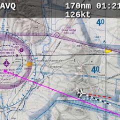
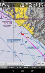
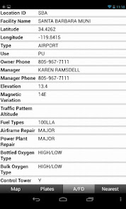
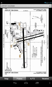
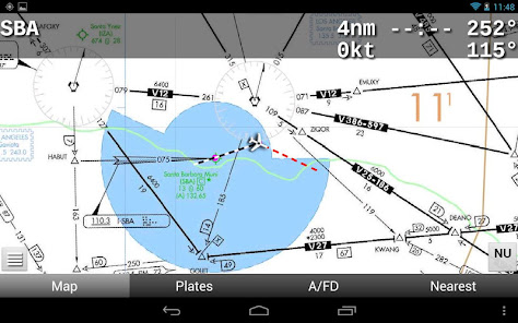
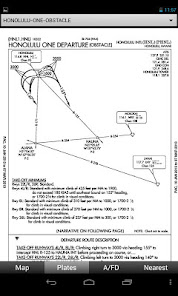
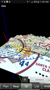
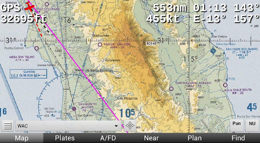
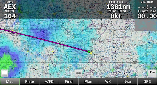
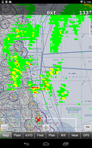
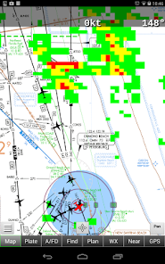
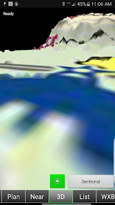
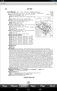
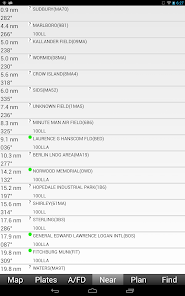
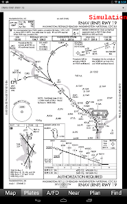
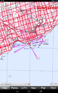
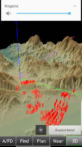
Avare offers offline moving map on all FAA charts (VFR Sectional, IFR lo/hi enroute, Approach Plate, WAC & TAC); plus A/FD info, Airport Diagrams w/GPS Taxi, and Terminal Procedures. Also: GPS status, Terrain/Elevation Maps, 50 Nearest airports, Obstacles, and more. Some FAA Charts cover Puerto Rico, plus parts of Canada, Mexico and the Caribbean. All of this is Completely Free with no ads.
*Note: Like all apps for portable devices, Avare is not FAA certified for primary navigation but may be used as outlined in FAA documents. See our NOTICE below, and the FAQ on our website for links to FAA documents.
Avare Advantages:
•Made by & for pilots
•Easy to learn & use
•Quick & responsive
•All free FAA materials & more
•Runs on most Android devices
•No ads or invasive permissions
More Features:
•Type in any address or coordinates.
•NOTAMS, METAR, TAF and Winds (Internet fetch or ADSB).
•ADSB TIS-B Traffic (UAT/1090), PIREP (free AddOn apps).
•Graphic & text TFRs (Internet fetch or ADSB).
•Canada topo, plus terrain maps for most of the world.
•External GPS, autopilot and flite sim options.
•Obstacles: Any over 500' AGL within 200' of GPS altitude.
•Frequencies, runways, fuel availability, & all A/FD info.
•13000+ GeoReferenced approach plates and taxi diagrams.
•Landscape/Portrait, North Up/Track Up (NU/TU) display.
•Draw notes on-screen, or Pan freely on charts (Draw/Pan).
•Long-Press any two points for approximate distance.
•Location icon Center, or track from your own placement.
•GPS compass direction, Bearing, and Distance to and FROM any point on the map by long-pressing one finger on that point. Great for your ATC and CTAF radio calls.
Avare installation begins with the small app, and then fetching an aviation Database and at least one chart. You can of course choose additional charts and materials for Avare to Download free at any time.
Note: The FAA occasionally changes their charts such that outdated charts may incorrectly display your location in Avare, so be sure to Update any charts you may use in flight! ANY time you plan to Update a chart, first ensure that you have the latest version of Avare and its Database.
After installing Avare, please use the Help feature to begin. New features are being added very quickly in response to user feedback, and may not be reflected in this Description page. You are invited to Contact us directly via our apps4av google group Forum to share your questions, feedback, and feature requests.
Launch Note: To access Help in the Avare app, on the Map screen tap the round Menu button, then the rectangular Help button at lower-left.
NOTICE: This software is provided "as is" and any express or implied warranties, including, but not limited to, implied warranties of merchantability and fitness for a particular purpose are disclaimed. In no event shall the copyright holder or contributors be liable for any direct, indirect, incidental, special, exemplary, or consequential damages (including, but not limited to loss of use or data) however caused and on any theory of liability, whether in contract, strict liability, or tort (including negligence or otherwise) arising in any way out of the use of this software, even if advised of the possibility of such damage.
** Aviation U.S. FAA materials and more. **
** No support in Reviews. **
** Please use our Friendly, helpful Support Forum. **
24/7 at: https://groups.google.com/forum/#!forum/apps4av-forum
**NOTE: Avare can't function fully until you turn on BOTH
of Avare's requested Permissions (Location & Storage).
Avare (pronounced "ah vAir" - like "aware" with a "v") is a free moving-map Aviation GPS & EFB app.
*Note: Internet access is required only for installing the free app, aviation Database, and at least 1 of the free charts; and for any updates. We recommend that you TURN OFF Play Store AUTOMATIC UPDATE for Avare, manually update it and all Downloads, then fly in Airplane Mode to save battery.
Avare offers offline moving map on all FAA charts (VFR Sectional, IFR lo/hi enroute, Approach Plate, WAC & TAC); plus A/FD info, Airport Diagrams w/GPS Taxi, and Terminal Procedures. Also: GPS status, Terrain/Elevation Maps, 50 Nearest airports, Obstacles, and more. Some FAA Charts cover Puerto Rico, plus parts of Canada, Mexico and the Caribbean. All of this is Completely Free with no ads.
*Note: Like all apps for portable devices, Avare is not FAA certified for primary navigation but may be used as outlined in FAA documents. See our NOTICE below, and the FAQ on our website for links to FAA documents.
Avare Advantages:
•Made by & for pilots
•Easy to learn & use
•Quick & responsive
•All free FAA materials & more
•Runs on most Android devices
•No ads or invasive permissions
More Features:
•Type in any address or coordinates.
•NOTAMS, METAR, TAF and Winds (Internet fetch or ADSB).
•ADSB TIS-B Traffic (UAT/1090), PIREP (free AddOn apps).
•Graphic & text TFRs (Internet fetch or ADSB).
•Canada topo, plus terrain maps for most of the world.
•External GPS, autopilot and flite sim options.
•Obstacles: Any over 500' AGL within 200' of GPS altitude.
•Frequencies, runways, fuel availability, & all A/FD info.
•13000+ GeoReferenced approach plates and taxi diagrams.
•Landscape/Portrait, North Up/Track Up (NU/TU) display.
•Draw notes on-screen, or Pan freely on charts (Draw/Pan).
•Long-Press any two points for approximate distance.
•Location icon Center, or track from your own placement.
•GPS compass direction, Bearing, and Distance to and FROM any point on the map by long-pressing one finger on that point. Great for your ATC and CTAF radio calls.
Avare installation begins with the small app, and then fetching an aviation Database and at least one chart. You can of course choose additional charts and materials for Avare to Download free at any time.
Note: The FAA occasionally changes their charts such that outdated charts may incorrectly display your location in Avare, so be sure to Update any charts you may use in flight! ANY time you plan to Update a chart, first ensure that you have the latest version of Avare and its Database.
After installing Avare, please use the Help feature to begin. New features are being added very quickly in response to user feedback, and may not be reflected in this Description page. You are invited to Contact us directly via our apps4av google group Forum to share your questions, feedback, and feature requests.
Launch Note: To access Help in the Avare app, on the Map screen tap the round Menu button, then the rectangular Help button at lower-left.
NOTICE: This software is provided "as is" and any express or implied warranties, including, but not limited to, implied warranties of merchantability and fitness for a particular purpose are disclaimed. In no event shall the copyright holder or contributors be liable for any direct, indirect, incidental, special, exemplary, or consequential damages (including, but not limited to loss of use or data) however caused and on any theory of liability, whether in contract, strict liability, or tort (including negligence or otherwise) arising in any way out of the use of this software, even if advised of the possibility of such damage.
Updated on
Safety starts with understanding how developers collect and share your data. Data privacy and security practices may vary based on your use, region, and age. The developer provided this information and may update it over time.

No data shared with third parties
Learn more about how developers declare sharing

No data collected
Learn more about how developers declare collection

Data is encrypted in transit

You can request that data be deleted
Ratings and reviews
4.7
4.5K reviews

Wayne Foster
- Flag inappropriate
March 25, 2024
Avare is a great free product/app for pilots looking for a navigation app with all the features found in other products that you would otherwise have to pay for. Traffic alert, weather info, maps for vfr and ifr, plates, supplemental info, and many many other features exist within the Avare app. I am able to plan a flight, and it also has filing capability although I have not tried filing a plan there yet. To appreciate what the Avare app has to offer each pillot needs to try it for themselves.
2 people found this review helpful

Ferdinand Badescu
- Flag inappropriate
- Show review history
December 13, 2023
I've been using Avare ever since it was released (some 7 years ago, if I'm not mistaken). Coupled with a Stratux ADSB it does almost everything Foreflight does. There's a lot of help available on the forum. What I would change: 1) The traffic symbol and color - traffic difficult to see as an arrow head, white box almost invisible on a VFR chart. Make it a triangle filled with a easy-to-see color, e.g. #00ff7f. 2) The map should change to the airport diagram when using an IFR chart, too.
5 people found this review helpful

Joseph Paroulek
- Flag inappropriate
- Show review history
November 1, 2020
Excellent EFB app. This is an open source app so it is truely free and is supported by volunteers. It has all the basic functions I need as an instrument rated private pilot. Map screens are not cluttered and you can select just the maps and coverage you need. Updates of maps and weather are easy one button push and downloads are fast. Works well on both my Samsung phone and tablet. I have been using Avare on my tablet with the stratux adsb receiver. I get in-flight traffic, METAR and NEXRAD.
18 people found this review helpful
What's new
Fixed FAA weather location changes
Ability to import/export ADSB recorded files
Increased map area size to reduce black borders in track up mode
Can start camera by pressing the volume button
SUAs show when pressed on map away from airports
Ability to import/export ADSB recorded files
Increased map area size to reduce black borders in track up mode
Can start camera by pressing the volume button
SUAs show when pressed on map away from airports
App support
phone
Phone number
+19784204655


