Gavarnie - Mont Perdu Rando3D
5.0star
7 reviews
100+
Downloads

Everyone
info

About this app
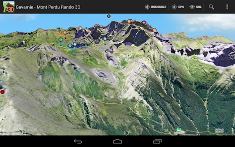
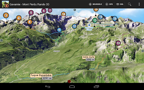
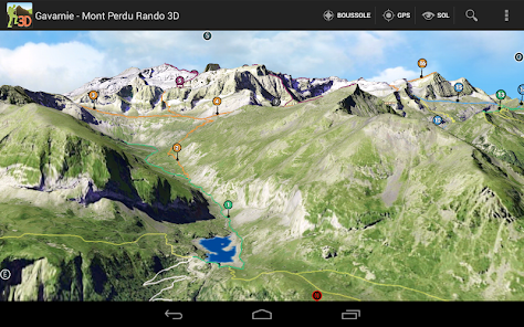
GAVARNIE - MONTE PERDIDO
Hautes Pyrénées (65) - Spain
3D map sector Mont Perdu - Estaubé - Gavarnie
Refuge Góriz (Spain) Valle de Bujaruelo (Spain)
Valley Campbieil (Gèdre) to Lakes Estom Soubiran (Pico Sède)
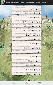
LIST OF HIKING
1 - Cirque Estaubé
2 - Refuge Tuquerouye, from Gloriettes
3 - New Port of Pinewood, from Gloriettes
4 - Refuge Tuquerouye from Gavarnie
5 - Mont Perdu from Tuquerouye
6 - Mont Perdu from the Refuge Góriz
7 - Small Astazou by the Northwest edge
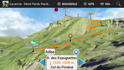
8 - The Piméné
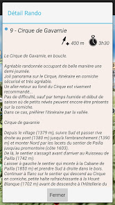
9 - Gavarnie
10 - Soum White Secugnat
11 - Peak and Lake La Bernatoire
12 - Loop Bellevue & Soldiers Hut
13 - Pico Pahule
14 - Pic Interlake Ports
15 - Refuge of the Breach of Roland - The Sarradets
16 - Breach of Roland - The Taillon
17 - The Marboré, from Sarradets
18 - From Refuge Sarradets at Refuge Góriz
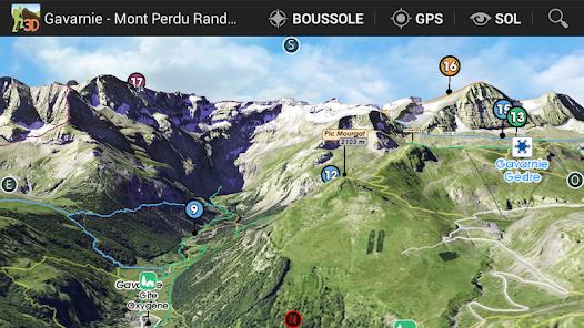
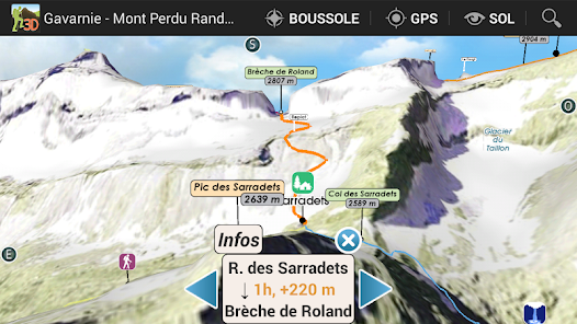
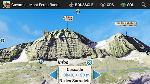
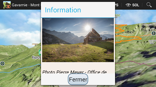
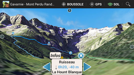
3D Hiking Guide
interactive and immersive application.
Take full advantage of this embedded hiking guide and map realistic.
The description of routes is detailed in dynamic 3D illustration.
All features are easy to use and accessible OFFLINE mountain oblige.
Good hiking at all.
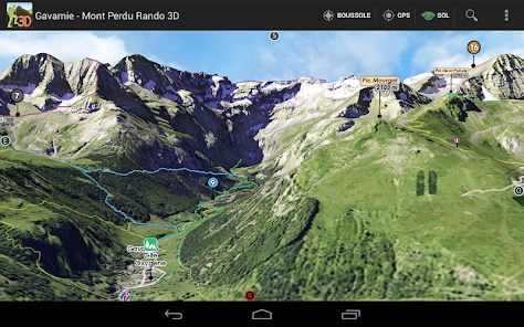
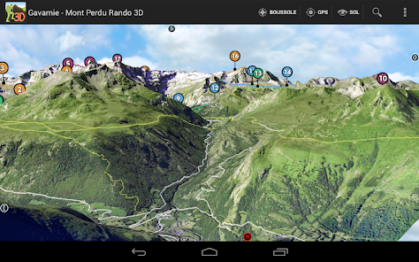
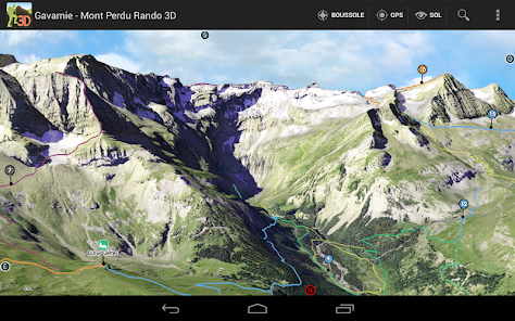
IMMERSIVE 3D FEATURES
○ intuitive and precise controls ... fingertips.
○ Aerial View, overview
○ View and taxiing
○ Compass
○ Geolocation
& DESIGN GUIDE
○ precise descriptions, text and visuals
○ Steps
○ Live View in 3D
GPS
The GPS of your phone is used for geolocation on the map area, it is particularly useful to see its position in the terrain, especially in poor visibility on the ground.
COMPASS
The compass mode is integrated in 3D, the cardinal points are oriented according to the manual movements or map automatically orients the north by activating the compass mode directly from the 3D.
RELIEF IN SIGHT & 3D SOL
The aerial view and floor to illustrate the general view raised to a level of precision optimized, it is displayed on the screen depending on the definition of the relief and texture chosen to launch the application automatically loaded or select according to device capabilities used.
The movement of the floor camera can appreciate the details of the route to follow and total immersion in the relief.
TRACKS
In addition to the described hiking trails mapped, variations and alternative routes, you can import your GPX tracks in the 3D map.
3D Interactive Application hiking guide - Facing the South TOPOMAP3D ® ® www.faceausud.com
Trademark and patented models 486299 08082013 - 12 3953606 © All rights reserved - No copying
With the kind of Helge Foerster JPCT 3D engine ® www.jpct.net Copyright © 2010
Hautes Pyrénées (65) - Spain
3D map sector Mont Perdu - Estaubé - Gavarnie
Refuge Góriz (Spain) Valle de Bujaruelo (Spain)
Valley Campbieil (Gèdre) to Lakes Estom Soubiran (Pico Sède)
LIST OF HIKING
1 - Cirque Estaubé
2 - Refuge Tuquerouye, from Gloriettes
3 - New Port of Pinewood, from Gloriettes
4 - Refuge Tuquerouye from Gavarnie
5 - Mont Perdu from Tuquerouye
6 - Mont Perdu from the Refuge Góriz
7 - Small Astazou by the Northwest edge
8 - The Piméné
9 - Gavarnie
10 - Soum White Secugnat
11 - Peak and Lake La Bernatoire
12 - Loop Bellevue & Soldiers Hut
13 - Pico Pahule
14 - Pic Interlake Ports
15 - Refuge of the Breach of Roland - The Sarradets
16 - Breach of Roland - The Taillon
17 - The Marboré, from Sarradets
18 - From Refuge Sarradets at Refuge Góriz
3D Hiking Guide
interactive and immersive application.
Take full advantage of this embedded hiking guide and map realistic.
The description of routes is detailed in dynamic 3D illustration.
All features are easy to use and accessible OFFLINE mountain oblige.
Good hiking at all.
IMMERSIVE 3D FEATURES
○ intuitive and precise controls ... fingertips.
○ Aerial View, overview
○ View and taxiing
○ Compass
○ Geolocation
& DESIGN GUIDE
○ precise descriptions, text and visuals
○ Steps
○ Live View in 3D
GPS
The GPS of your phone is used for geolocation on the map area, it is particularly useful to see its position in the terrain, especially in poor visibility on the ground.
COMPASS
The compass mode is integrated in 3D, the cardinal points are oriented according to the manual movements or map automatically orients the north by activating the compass mode directly from the 3D.
RELIEF IN SIGHT & 3D SOL
The aerial view and floor to illustrate the general view raised to a level of precision optimized, it is displayed on the screen depending on the definition of the relief and texture chosen to launch the application automatically loaded or select according to device capabilities used.
The movement of the floor camera can appreciate the details of the route to follow and total immersion in the relief.
TRACKS
In addition to the described hiking trails mapped, variations and alternative routes, you can import your GPX tracks in the 3D map.
3D Interactive Application hiking guide - Facing the South TOPOMAP3D ® ® www.faceausud.com
Trademark and patented models 486299 08082013 - 12 3953606 © All rights reserved - No copying
With the kind of Helge Foerster JPCT 3D engine ® www.jpct.net Copyright © 2010
Updated on
Data safety
Developers can show information here about how their app collects and uses your data. Learn more about data safety

No information available
Ratings and reviews
5.0
7 reviews
What's new
Optimisation du modèle 3D du terrain.


