
FuraCAR - Cad Ambiental Rural

3.8star
23 reviews
100+
Downloads

Everyone
info


About this app
Application to assist in Environmental Rural Register through the demarcation of geographical layers.
Key features:
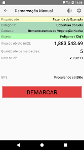
★ Demarcation all layers provided in the CAR;
★ Demarcation manual (the user decides when to get coordinated);
Demarcation ★ automatic (the user specifies the time interval for capturing coordinates);
★ Editing marked objects (the user can correct notes directly in the application);
★ file generation KML and Shapefile;
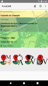
★ Support for multiple properties;
★ Option to sound alerts and vibration when the coordinates are updated;
Key Features:
★ Works offline so no need internet to function, only the GPS;
joined realization of geographical layers of the CAR, using the device's GPS, allowing automatic and manual demarcation.
Through it, the owner has the possibility of demarcating the layers in more detail.
Suitable mainly to farms that do not have good quality pictures or maps with necessary information.
demarcation of geographical layers opportunity "in loco".
In addition to allowing the demarcation of all geographic layers of the CAR, the application of export KML and Shapefile, allowing subsequent import pages of state SICAR (government software).
Allows editing of the marked objects, giving option to correct any faults in the phone's GPS.
Key features:
★ Demarcation all layers provided in the CAR;
★ Demarcation manual (the user decides when to get coordinated);
Demarcation ★ automatic (the user specifies the time interval for capturing coordinates);
★ Editing marked objects (the user can correct notes directly in the application);
★ file generation KML and Shapefile;
★ Support for multiple properties;
★ Option to sound alerts and vibration when the coordinates are updated;
Key Features:
★ Works offline so no need internet to function, only the GPS;
joined realization of geographical layers of the CAR, using the device's GPS, allowing automatic and manual demarcation.
Through it, the owner has the possibility of demarcating the layers in more detail.
Suitable mainly to farms that do not have good quality pictures or maps with necessary information.
demarcation of geographical layers opportunity "in loco".
In addition to allowing the demarcation of all geographic layers of the CAR, the application of export KML and Shapefile, allowing subsequent import pages of state SICAR (government software).
Allows editing of the marked objects, giving option to correct any faults in the phone's GPS.
Updated on
Safety starts with understanding how developers collect and share your data. Data privacy and security practices may vary based on your use, region, and age. The developer provided this information and may update it over time.


Ratings and reviews
3.8
23 reviews
What's new
Version 2.7
★ Support Android 13 Tiramisu;
★ Updated Google Maps API;
★ API 19 minimum supported - Kitkat - Android 4.4;
