Ghisoni
5.0star
22 reviews
1K+
Downloads

Everyone
info

About this app
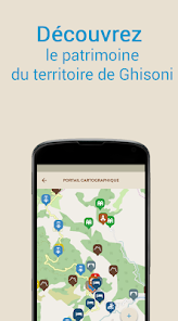
MAPPING PORTAL
Discover the territory of the municipality of Ghisoni.
Since the interactive map you will locate easily using filters and attractions located in the municipality (trailheads and hiking, mountains, mountain lakes, shops, built heritage and religious, sports, place names derived from an oral survey ...).
HIKING
Stroll through the marked trails around the village, take the footpaths of the Monte Renosu Pozzi or via Lake Bastani.
A description of each excursion will be available on the application (level of difficulty, distance, elevation profile ...). You can also download map money for use offline.
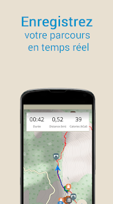
MY JOURNEY
Save your route (GPS track) or free rides.
For each registered route, the application gives you:
- GPS track.
- The elevation profile
- Travel time calculations, average speed ...
You also have the option to share your journey on the social network.
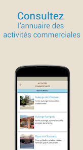
DIRECTORY OF BUSINESSES AND PROFESSIONALS OF THE MOUNTAIN
Discover the shops classified by industry and professionals of the mountain.
Want a good meal, to stay or to discover our many hikes on the GR20 accompanied by a professional, all the places are on our application.
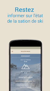
THE SKI RESORT GHISONI Capanelle
With the application of Ghisoni Capanelle find information about your station in Corsica:
- The ski resort and shops on site
- Ski map
- Weather and daily snow report
- Consultation webcams
Discover the territory of the municipality of Ghisoni.
Since the interactive map you will locate easily using filters and attractions located in the municipality (trailheads and hiking, mountains, mountain lakes, shops, built heritage and religious, sports, place names derived from an oral survey ...).
HIKING
Stroll through the marked trails around the village, take the footpaths of the Monte Renosu Pozzi or via Lake Bastani.
A description of each excursion will be available on the application (level of difficulty, distance, elevation profile ...). You can also download map money for use offline.
MY JOURNEY
Save your route (GPS track) or free rides.
For each registered route, the application gives you:
- GPS track.
- The elevation profile
- Travel time calculations, average speed ...
You also have the option to share your journey on the social network.
DIRECTORY OF BUSINESSES AND PROFESSIONALS OF THE MOUNTAIN
Discover the shops classified by industry and professionals of the mountain.
Want a good meal, to stay or to discover our many hikes on the GR20 accompanied by a professional, all the places are on our application.
THE SKI RESORT GHISONI Capanelle
With the application of Ghisoni Capanelle find information about your station in Corsica:
- The ski resort and shops on site
- Ski map
- Weather and daily snow report
- Consultation webcams
Updated on
Safety starts with understanding how developers collect and share your data. Data privacy and security practices may vary based on your use, region, and age. The developer provided this information and may update it over time.

This app may share these data types with third parties
Location and App activity

No data collected
Learn more about how developers declare collection

Data is encrypted in transit

Data can’t be deleted
Ratings and reviews
5.0
22 reviews