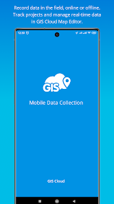
Mobile Data Collection

4.0star
448 reviews
100K+
Downloads

Everyone
info


About this app
GIS Cloud Mobile Data Collection is a solution for recording and updating data in the field with mobile devices in real time, also allowing instant data access from the office. Digitize your workflow and eliminate errors and time-consuming paperwork!
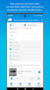
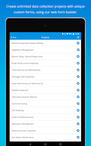
The mobile app enables you to accurately record data, online or offline, by filling in digital custom survey forms. You can create an unlimited number of your own unique forms in the user-friendly form builder, in the connected web app (Mobile Data Collection Portal).
Continue working on your data, edit, share, and collaborate through GIS Cloud powerful web Map Editor app. Find everything you need for your workflow in one platform, no need for integrations.
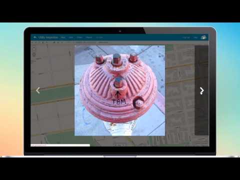
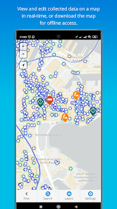
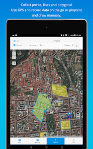
Collect points, lines, or polygons! Use GPS to capture data on the go, or switch to manual and use pinpoint and drawing tools for even better precision.
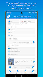
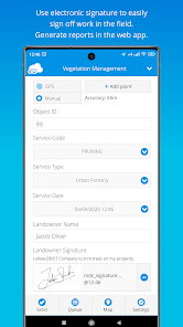
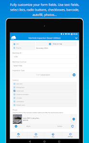
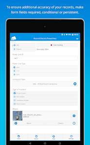
Form fields are fully customizable and you can choose from text fields, selects lists, radio buttons, checkboxes, electronic signature, autofill, barcode, photo and audio, hidden fields, and much more. To control data accuracy and eliminate errors, make your form fields required, conditional (dependent on other form fields or data input), or persistent.
Manage your field staff and share projects with custom forms to field workers by assigning them the collect and update permissions, and they can instantly start collecting data in the field.
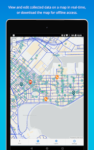
Simply sign into your GIS Cloud account (or sign up for free) and send collected data directly to your GIS Cloud app in the cloud. Data is immediately represented on a map, just click on any map feature to access collected data. Generate reports from the web app.
Access data through GIS Cloud Map Editor, where you can further edit and style your data, overlay with additional data layers analyze data, share data with colleagues with different permissions to collaborate on projects. You can also export data and much more.
Collect field data and conduct field surveys faster and easier than ever before. Start creating forms in the MDC Portal web app on https://giscloud.com and have your team out and about in a quarter of an hour!
All you need in the field:
- Offline data capture
- Offline maps
- Points, Lines, and Polygons geometry support
- Media (photos & audio) enriched location information
- QR code and barcode support
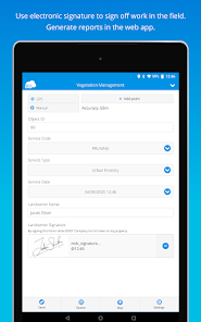
- Electronic signature
- Dropdowns, lists, input boxes, and comments based on custom forms
- Review data attributes directly in the app
- Search through data on the map
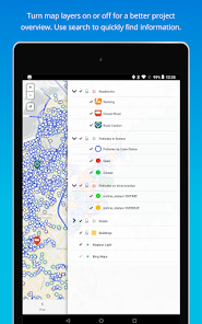
- Control different layers in the map
- Edit existing data
- Listen to audio and view images
- Real-time GPS location
- View and explore maps in the field
Prepare and analyze in the office:
- Cloud-based web apps
- Custom forms designer
- Rich GIS symbology and visualization
- Data editing and exporting
- One-click map and data sharing
- Real-time collaboration
- Map publishing
- Spatial Queries & Analysis
- Account administration
Note! This app will use GPS in the background to give you the most accurate and current location. Continued use of GPS running in the background can dramatically decrease battery life.
The mobile app enables you to accurately record data, online or offline, by filling in digital custom survey forms. You can create an unlimited number of your own unique forms in the user-friendly form builder, in the connected web app (Mobile Data Collection Portal).
Continue working on your data, edit, share, and collaborate through GIS Cloud powerful web Map Editor app. Find everything you need for your workflow in one platform, no need for integrations.
Collect points, lines, or polygons! Use GPS to capture data on the go, or switch to manual and use pinpoint and drawing tools for even better precision.
Form fields are fully customizable and you can choose from text fields, selects lists, radio buttons, checkboxes, electronic signature, autofill, barcode, photo and audio, hidden fields, and much more. To control data accuracy and eliminate errors, make your form fields required, conditional (dependent on other form fields or data input), or persistent.
Manage your field staff and share projects with custom forms to field workers by assigning them the collect and update permissions, and they can instantly start collecting data in the field.
Simply sign into your GIS Cloud account (or sign up for free) and send collected data directly to your GIS Cloud app in the cloud. Data is immediately represented on a map, just click on any map feature to access collected data. Generate reports from the web app.
Access data through GIS Cloud Map Editor, where you can further edit and style your data, overlay with additional data layers analyze data, share data with colleagues with different permissions to collaborate on projects. You can also export data and much more.
Collect field data and conduct field surveys faster and easier than ever before. Start creating forms in the MDC Portal web app on https://giscloud.com and have your team out and about in a quarter of an hour!
All you need in the field:
- Offline data capture
- Offline maps
- Points, Lines, and Polygons geometry support
- Media (photos & audio) enriched location information
- QR code and barcode support
- Electronic signature
- Dropdowns, lists, input boxes, and comments based on custom forms
- Review data attributes directly in the app
- Search through data on the map
- Control different layers in the map
- Edit existing data
- Listen to audio and view images
- Real-time GPS location
- View and explore maps in the field
Prepare and analyze in the office:
- Cloud-based web apps
- Custom forms designer
- Rich GIS symbology and visualization
- Data editing and exporting
- One-click map and data sharing
- Real-time collaboration
- Map publishing
- Spatial Queries & Analysis
- Account administration
Note! This app will use GPS in the background to give you the most accurate and current location. Continued use of GPS running in the background can dramatically decrease battery life.
Updated on
Safety starts with understanding how developers collect and share your data. Data privacy and security practices may vary based on your use, region, and age. The developer provided this information and may update it over time.

No data shared with third parties
Learn more about how developers declare sharing

This app may collect these data types
Location, Personal info and 4 others

Data isn’t encrypted

You can request that data be deleted
Ratings and reviews
4.0
411 reviews

A Google user
- Flag inappropriate
March 13, 2019
Well deisgned app. But subscriptions are too expensive. And free version is far too limiting, once you have uploaded data you use your allowable cloud space, even if you delete all data there is no cloud space for you to upload to.
59 people found this review helpful
GIS Cloud
March 14, 2019
Hi Grant,
it is possible to free up your cloud space, you just have to delete the data from the file and database manager.
If you have any issues with that you can always contact our Support Team at support@giscloud.com or through our live support feature on the web and we'll help you along.

tnb 002 cs
- Flag inappropriate
January 14, 2022
When i open the apps ... I want to take a picture... The camera not functioning.... I do manual first i take a picture on my phone camera then go to apps and select button add from album... What the fish 😌😌😌
23 people found this review helpful
GIS Cloud
January 14, 2022
Hi there,
we're sorry to hear you're having issues with the app! Our support and QA teams tried to reproduce the issue but couldn't so it would be great if you could share more information about your current setup.
Would it be possible for you to reach out to us at premium-support@giscloud.com and share more information there?
Thank you!

ONWUDIWE CHINEDU JOSEPH
- Flag inappropriate
March 4, 2021
Please this version is the worst version....the older version is better than this.....while working on the map, the map disappears all the time.....
25 people found this review helpful
GIS Cloud
March 4, 2021
Hi there! Sorry to see you're having issues with the application. We have checked the latest released version again and we couldn't find any issues with it nor we received any complaints from existing users. We assume the issue might be with the map itself and not the app so please reach out to us at support@giscloud.com so we could investigate.
What's new
Fixes:
• enhanced UX for viewing feature attached media files
• fixed behaviour of the photo quality setting
• enhanced UX for viewing feature attached media files
• fixed behaviour of the photo quality setting


