
Mapas Cantabria
4.0star
80 reviews
10K+
Downloads

Everyone
info


About this app
The Mapas Cantabria app for phones and tablets makes navigating the cartography of Gobierno de Cantabria faster and easier than ever:
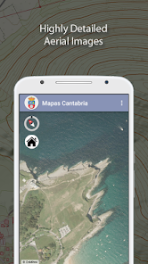
• Comprehensive, accurate and highly detailed maps all over Cantabria.
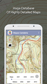
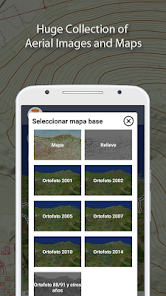
• Huge collection of orthoimagery adquired at different dates.
• Full GPS location shows your actual position and bearing.
• Create and read your own GPX route files for hiking.
• Works offline. Download basemaps and work with them even if you have no access to the Internet.
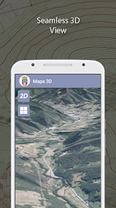
• Astounding 3D views*
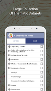
• Wide catalog of thematic information.
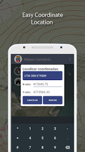
• Query and locate coordinates in different formats.
• Find geographical names from our extensive and comprenhensive database.
• Create sketches drawing points, lines, polygons and texts and export the resulting maps to PDF or image format.
• Measure elements.
• Overlay remote WMS services from external servers (IGN, cadastre and other servers from Spain or abroad).
* Some features not available in all the devices.
• Comprehensive, accurate and highly detailed maps all over Cantabria.
• Huge collection of orthoimagery adquired at different dates.
• Full GPS location shows your actual position and bearing.
• Create and read your own GPX route files for hiking.
• Works offline. Download basemaps and work with them even if you have no access to the Internet.
• Astounding 3D views*
• Wide catalog of thematic information.
• Query and locate coordinates in different formats.
• Find geographical names from our extensive and comprenhensive database.
• Create sketches drawing points, lines, polygons and texts and export the resulting maps to PDF or image format.
• Measure elements.
• Overlay remote WMS services from external servers (IGN, cadastre and other servers from Spain or abroad).
* Some features not available in all the devices.
Updated on
Safety starts with understanding how developers collect and share your data. Data privacy and security practices may vary based on your use, region, and age. The developer provided this information and may update it over time.

No data shared with third parties
Learn more about how developers declare sharing

No data collected
Learn more about how developers declare collection
Ratings and reviews
4.0
80 reviews
What's new
Incompatibility with some devices fixed.
App support
phone
Phone number
+34942209900