
iHunter Alberta
In-app purchases
3.8star
507 reviews
10K+
Downloads

Everyone
info
About this app
Don't be confused by imitators. iHunter Alberta is the #1 Hunting app for Albertans (with the ratings to back it up)!
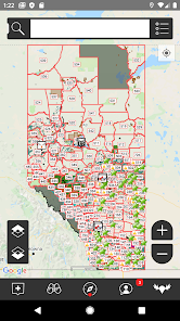
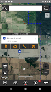
iHunter Alberta gives hunters and outdoor enthusiasts a new view into Alberta's wildlife management units. By overlaying the WMUs on top of base maps, users can see their current location and which WMU they are in. Dive deeper into specific WMUs to see which big game, bear, cougar, and game bird seasons are open. Contribute to the map by adding your own waypoints to keep track of hunting spots, past animal harvests, and landowner contact information.
Features:
- Includes regulation summary for the current season (free updates every year)
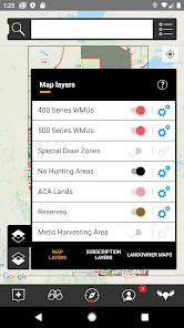
- View WMUs on top of base maps (map, hybrid, satellite and terrain views)
- View No-hunting zones and Indian reserve boundaries
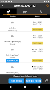
- Select a WMU to view its summary of big-game, predator and game bird seasons
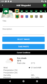
- Add waypoints to the map at your current location or the centre of the map
- Add waypoints to the map based on your known GPS locations
- Edit the name, description, image and location of your waypoints
- Store Landowner contact information in waypoints to keep track of all your hunting contacts in one place
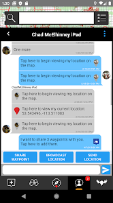
- Send your friends or family an email with your current location so they can easily find you
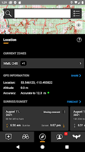
- Use the sunrise / sunset calculator to look up legal hunting light at your location
- Share waypoints via email to friends and hunting partners
- Text your location to other users
- Chat with other users
- Share waypoints, current location, and your live location
- Track your position as you hunt - get an altitude and velocity profile as well as a track overlaid on the map
- Draw over the map to highlight property lines, animal patterns, or trails
- Search the map for businesses or points of interest (internet connection required)
- Recently viewed and favorites lists for WMUs and waypoints
Public Land Access In-App Subscription ($9.99 per year):
- View over 6000 Agricultural Leases (Grazing Leases, Farm Development Leases) overtop of the existing iHunter map
- Tap and hold on any lease to view the leaseholder name, contact info, and specific restrictions
- Search for leases by proximity, disposition number, leaseholder name, and content of the restrictions
- Favorites list and most recently used list
- View the Alberta "Green Area" boundaries (area of the province that is primarily public land). Note that there is some lease and private land within this area.
- View over 25000 Pipeline Agreements, Utility right-of ways and other easements that are considered Vacant Public Land when not being developed
- All for $9.99 per year
County Land Ownership Maps: 70 maps to choose from, between $9.99 and $30 CAD each.
iHunter Alberta gives hunters and outdoor enthusiasts a new view into Alberta's wildlife management units. By overlaying the WMUs on top of base maps, users can see their current location and which WMU they are in. Dive deeper into specific WMUs to see which big game, bear, cougar, and game bird seasons are open. Contribute to the map by adding your own waypoints to keep track of hunting spots, past animal harvests, and landowner contact information.
Features:
- Includes regulation summary for the current season (free updates every year)
- View WMUs on top of base maps (map, hybrid, satellite and terrain views)
- View No-hunting zones and Indian reserve boundaries
- Select a WMU to view its summary of big-game, predator and game bird seasons
- Add waypoints to the map at your current location or the centre of the map
- Add waypoints to the map based on your known GPS locations
- Edit the name, description, image and location of your waypoints
- Store Landowner contact information in waypoints to keep track of all your hunting contacts in one place
- Send your friends or family an email with your current location so they can easily find you
- Use the sunrise / sunset calculator to look up legal hunting light at your location
- Share waypoints via email to friends and hunting partners
- Text your location to other users
- Chat with other users
- Share waypoints, current location, and your live location
- Track your position as you hunt - get an altitude and velocity profile as well as a track overlaid on the map
- Draw over the map to highlight property lines, animal patterns, or trails
- Search the map for businesses or points of interest (internet connection required)
- Recently viewed and favorites lists for WMUs and waypoints
Public Land Access In-App Subscription ($9.99 per year):
- View over 6000 Agricultural Leases (Grazing Leases, Farm Development Leases) overtop of the existing iHunter map
- Tap and hold on any lease to view the leaseholder name, contact info, and specific restrictions
- Search for leases by proximity, disposition number, leaseholder name, and content of the restrictions
- Favorites list and most recently used list
- View the Alberta "Green Area" boundaries (area of the province that is primarily public land). Note that there is some lease and private land within this area.
- View over 25000 Pipeline Agreements, Utility right-of ways and other easements that are considered Vacant Public Land when not being developed
- All for $9.99 per year
County Land Ownership Maps: 70 maps to choose from, between $9.99 and $30 CAD each.
Updated on
Safety starts with understanding how developers collect and share your data. Data privacy and security practices may vary based on your use, region, and age. The developer provided this information and may update it over time.


Ratings and reviews
3.8
480 reviews

Biff 99
- Flag inappropriate
- Show review history
January 15, 2024
Helpful app for identifying back road access and crown land. However, many of the landowners maps are not up to date. The one for my WMU has not been updated for several years. It's safer to purchase the map from your county or MD, as some areas identified as crown are now privately owned.
1 person found this review helpful
Inside Outside Studios Inc.
January 15, 2024
Hi,
We do our best to provide up to date landowner maps, unfortunately we are typically licensing them in which case we don't have control over the frequency. For maps that we produce in-house, they take months to create, but we're doing our best to speed that up in 2024.

Tycro Eq
- Flag inappropriate
- Show review history
April 25, 2023
Need to fix it. When you click on leased land and the person who owns the lease when you try to back out, it reloads the entire province map and you forget where you were looking. You have to zoom back in to try to find it. Very annoying. Update After working with tech support, who was extremely helpful and patient. We found out it was because I had devolper options turned on. Thanks for the help 5 stars
15 people found this review helpful
Inside Outside Studios Inc.
April 20, 2023
Hi,
Could you email us at info@ihunterapp.com? This is not at all how the app works so you must be experiencing a bug. It's also worth noting that this isn't happening on any of my devices and nobody else has reported this, so there's a good chance it's something specific to your setup. I'll need you to write on so I can help you resolve the issue.

Liam Kavanagh-Bradette
- Flag inappropriate
- Show review history
October 15, 2023
App's confusing and not very clear, once you start to figure it out then it's actually very detailed. But you have to pay for the app, plus $15/map and each WMU is over lapped by sometimes 3 different maps which means I've had to spend $50 this season just to get what I need for a single WMU. Edit: 1) I was mistaken one of the maps I needed was $30 (plus 2 for $15). 2) You're providing the only option for hunters, if you're going to charge for the maps, take the extra time and sell them by WMU.
18 people found this review helpful
Inside Outside Studios Inc.
October 14, 2023
None of this should be a surprise. It's outlined in the app description, at ihunterapp.com, and at store.ihunterapp.com. Landowner maps are licensed from the counties and are therefore sold by county. They take considerable time and money to develop, so they can't reasonably be provided for free.
As for clarity, please email us with suggestions.


