Plants and Fungi of SW NSW Aus
1K+
Downloads

Everyone
info


About this app
Plants and Fungi of South West New South Wales has been updated. In particular, the key now reflects recent changes to legislation on threatened plants, and on weeds.
47 plant species have been added, including all those recorded from Kinchega National Park. 12 species, which are now regarded as never have been recorded in the area covered by the app, have been deleted.
A number of additional images have been added.
Several features, e.g. number of ‘petals’/lobes, which were previously keyed using tick boxes, are now keyed by entering the number or range. Several other features, such as flower size, have been added.
A number of corrections have been made, both to the facts sheets and to the key.
These additions and changes will improve the certainty of plant identification in this area.
About 'Plants and Fungi of SW NSW Australia'
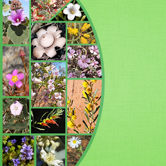
This key is designed for anyone who has an interest in finding out about the plants and fungi of south western New South Wales. It includes about 1100 species, accompanied by over 3000 images.
The key uses a limited number of easily seen characters using a minimum of technical terms to help with identification of plants. It is not designed to key out to a single species, though sometimes it does. It is designed to narrow down the possibilities of what the plant might be to a limited number of species. The photos may then help you decide what your plant is.
In most cases, the use of a hand lens is not necessary for identification. Identification needing the use of even a low power microscope, or a detailed knowledge of technical terms, is beyond the scope of the key.
The character "ligules" (for grasses) is the only character in the key that requires a hand lens. A hand lens will also be helpful for other characters e.g. "spikelet length" for grasses with small seeds.
The northern boundary of the area covered by the key is a line drawn from 33o S 141o E to 33o S 143.25o E, the west boundary is along the South Australian border, the south boundary the northern bank of the Murray River, and the east boundary a line south from 33o S 143.25o E to the north bank of the Murray River (an area south and west from a few kilometres north and east of Mungo National Park).
Government reserves in the area are: Tarawi Nature Reserve, Mallee Cliffs National Park, Mungo National Park, Mungo State Conservation Area, Nearie Lake Nature Reserve, Euston Regional Park, Kemendok National Park, and Kemendok Nature Reserve. Non-government reserves are Scotia Sanctuary (Australian Wildlife Conservancy) and Nanya Station (University of Ballarat).
The key also covers (in NSW) nearly all of the species recorded from Kinchega National Park, and most of the species from the Murrumbidgee Valley reserves (National Park, Nature Reserve, and State Conservaton Area) and Willandra National Park, (in SA) most of the species from Danggali Conservation Park and Wilderness Reserve, Calperum Pastoral Lease and Scientific Reserve, Chowilla Game and Regional Reserve, and Birds Australia Gluepot Reserve, (in Vic) most of the species in north west Victoria, which includes the reserves: Murray Sunset National Park, Hattah-Kulkyne and Murray-Kulkyne National Parks, and Annuello Flora and Fauna Reserve.
47 plant species have been added, including all those recorded from Kinchega National Park. 12 species, which are now regarded as never have been recorded in the area covered by the app, have been deleted.
A number of additional images have been added.
Several features, e.g. number of ‘petals’/lobes, which were previously keyed using tick boxes, are now keyed by entering the number or range. Several other features, such as flower size, have been added.
A number of corrections have been made, both to the facts sheets and to the key.
These additions and changes will improve the certainty of plant identification in this area.
About 'Plants and Fungi of SW NSW Australia'
This key is designed for anyone who has an interest in finding out about the plants and fungi of south western New South Wales. It includes about 1100 species, accompanied by over 3000 images.
The key uses a limited number of easily seen characters using a minimum of technical terms to help with identification of plants. It is not designed to key out to a single species, though sometimes it does. It is designed to narrow down the possibilities of what the plant might be to a limited number of species. The photos may then help you decide what your plant is.
In most cases, the use of a hand lens is not necessary for identification. Identification needing the use of even a low power microscope, or a detailed knowledge of technical terms, is beyond the scope of the key.
The character "ligules" (for grasses) is the only character in the key that requires a hand lens. A hand lens will also be helpful for other characters e.g. "spikelet length" for grasses with small seeds.
The northern boundary of the area covered by the key is a line drawn from 33o S 141o E to 33o S 143.25o E, the west boundary is along the South Australian border, the south boundary the northern bank of the Murray River, and the east boundary a line south from 33o S 143.25o E to the north bank of the Murray River (an area south and west from a few kilometres north and east of Mungo National Park).
Government reserves in the area are: Tarawi Nature Reserve, Mallee Cliffs National Park, Mungo National Park, Mungo State Conservation Area, Nearie Lake Nature Reserve, Euston Regional Park, Kemendok National Park, and Kemendok Nature Reserve. Non-government reserves are Scotia Sanctuary (Australian Wildlife Conservancy) and Nanya Station (University of Ballarat).
The key also covers (in NSW) nearly all of the species recorded from Kinchega National Park, and most of the species from the Murrumbidgee Valley reserves (National Park, Nature Reserve, and State Conservaton Area) and Willandra National Park, (in SA) most of the species from Danggali Conservation Park and Wilderness Reserve, Calperum Pastoral Lease and Scientific Reserve, Chowilla Game and Regional Reserve, and Birds Australia Gluepot Reserve, (in Vic) most of the species in north west Victoria, which includes the reserves: Murray Sunset National Park, Hattah-Kulkyne and Murray-Kulkyne National Parks, and Annuello Flora and Fauna Reserve.
Updated on
Safety starts with understanding how developers collect and share your data. Data privacy and security practices may vary based on your use, region, and age. The developer provided this information and may update it over time.

No data shared with third parties
Learn more about how developers declare sharing

No data collected
Learn more about how developers declare collection
What's new
Updated to the latest version of LucidMobile


