
Land id™
In-app purchases
2.6star
359 reviews
100K+
Downloads

Everyone
info


About this app
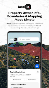
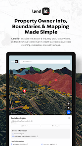
Land id™ is the leading provider of land identity™ and interactive property mapping applications, available on both mobile and web. With the Discover, Pro and Pro Unlimited plans, Land id™ offers solutions for anyone that is curious about land and property ownership including potential land buyers and land owners, as well as map creation solutions for real estate industry professionals. Land id™ solutions are used by professionals across multiple industries including land sales, residential and commercial real estate brokerages, property appraisals, agricultural farm and ranch management, forestry, government, engineering and renewables. Major Clients include Whitetail Properties, Keller-Williams Realty, Sotheby’s International Realty, Engle & Völkers, Coldwell Banker, eXp Realty, Berkshire Hathaway HomeServices, Fay Ranches, Mossy Oak Properties, National Land Realty, Hall & Hall, Peoples Company, Heritage Land Bank.
► FREE TRIAL
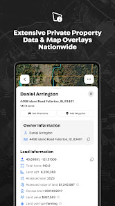
With the 7 day free trial, you’ll have full access to Land id™ Discover, providing property ownership details and boundaries on over 150 million private and public parcels across all 50 states:
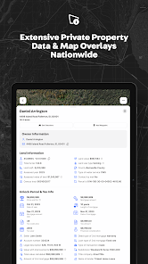
◦ Access to dozens of property attributes including legal description, property ID (APN) and tract numbers, acreage, land use, school district, building attributes, existing mortgage information, property type - and much more
◦ Satellite, aerial imagery, and topographic overlays
◦ Most recent tax information including last assessed year, tax amount, tax code area, total calculated value
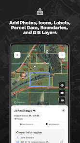
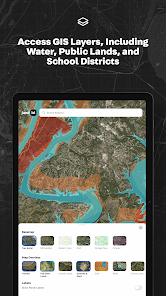
◦ Access to mapping layers and overlays including water features, wetlands, FEMA flood plains, soil types, topo lines, city and county lines and much more.
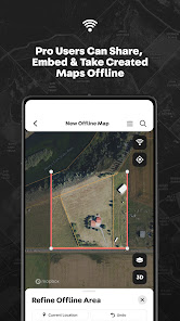
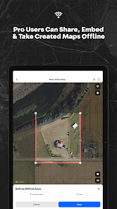
◦ Offline access to all property information and mapping layers for in-field use
◦ Built-in satellite GPS tracking, enabling a user to see his or her location on the map in proximity to property boundaries, buildings, fencelines or anything on the map
◦ Mark points on the map to identify locations of property elements such as structures, views, wells, etc.
◦ Land id™ Discover is available as a monthly or annual subscription for an introductory price of $14.99/month or $79.99/year (56% savings)
► UPGRADE TO LAND ID™ PRO & PRO UNLIMITED
Land id™ Pro and Pro Unlimited enable real estate and industry professionals to create their own highly detailed and accurate interactive property maps for use in the field or in the office with web and mobile devices.
◦ Includes all Land id™ Discover capabilities and nationwide access to parcel information
◦ Desktop map creation with access to our online web mapping solution
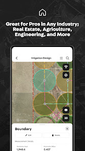
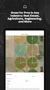
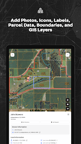
◦ Intuitive map tools provide the ability to highlight the locations of buildings and property infrastructure, embed photos and videos of unique property features, drop in panoramic images, and measure the length of a road, fence or shoreline
◦ Land id™ deed plotter and geospatial tools enable real estate pros to overlay digital plat and survey images directly on the map, resulting in a near survey-grade interactive digital map
◦ Publish and embed maps directly on your website to showcase property listings and property elements
◦ Share maps via text or email to clients and potential buyers
◦ Land id™ Pro is available for $49.99/month or $399.99/year (33% savings)
◦ Land id™ Pro Unlimited with unlimited map creation, multi-user support and centralized billing is available for $79.99/month or $799.99/year (17% savings)
Privacy Policy: id.land/legal/terms-of-service
Terms of Use: id.land/legal/privacy-policy
Your subscription will automatically renew and your account will be charged unless auto-renew is turned off at least 24-hours before the end of the current period. You can manage your subscription and turn off auto-renewal by going to your Account Settings after purchase. No cancellation of the current subscription is allowed during the active subscription period.
► FREE TRIAL
With the 7 day free trial, you’ll have full access to Land id™ Discover, providing property ownership details and boundaries on over 150 million private and public parcels across all 50 states:
◦ Access to dozens of property attributes including legal description, property ID (APN) and tract numbers, acreage, land use, school district, building attributes, existing mortgage information, property type - and much more
◦ Satellite, aerial imagery, and topographic overlays
◦ Most recent tax information including last assessed year, tax amount, tax code area, total calculated value
◦ Access to mapping layers and overlays including water features, wetlands, FEMA flood plains, soil types, topo lines, city and county lines and much more.
◦ Offline access to all property information and mapping layers for in-field use
◦ Built-in satellite GPS tracking, enabling a user to see his or her location on the map in proximity to property boundaries, buildings, fencelines or anything on the map
◦ Mark points on the map to identify locations of property elements such as structures, views, wells, etc.
◦ Land id™ Discover is available as a monthly or annual subscription for an introductory price of $14.99/month or $79.99/year (56% savings)
► UPGRADE TO LAND ID™ PRO & PRO UNLIMITED
Land id™ Pro and Pro Unlimited enable real estate and industry professionals to create their own highly detailed and accurate interactive property maps for use in the field or in the office with web and mobile devices.
◦ Includes all Land id™ Discover capabilities and nationwide access to parcel information
◦ Desktop map creation with access to our online web mapping solution
◦ Intuitive map tools provide the ability to highlight the locations of buildings and property infrastructure, embed photos and videos of unique property features, drop in panoramic images, and measure the length of a road, fence or shoreline
◦ Land id™ deed plotter and geospatial tools enable real estate pros to overlay digital plat and survey images directly on the map, resulting in a near survey-grade interactive digital map
◦ Publish and embed maps directly on your website to showcase property listings and property elements
◦ Share maps via text or email to clients and potential buyers
◦ Land id™ Pro is available for $49.99/month or $399.99/year (33% savings)
◦ Land id™ Pro Unlimited with unlimited map creation, multi-user support and centralized billing is available for $79.99/month or $799.99/year (17% savings)
Privacy Policy: id.land/legal/terms-of-service
Terms of Use: id.land/legal/privacy-policy
Your subscription will automatically renew and your account will be charged unless auto-renew is turned off at least 24-hours before the end of the current period. You can manage your subscription and turn off auto-renewal by going to your Account Settings after purchase. No cancellation of the current subscription is allowed during the active subscription period.
Updated on
Safety starts with understanding how developers collect and share your data. Data privacy and security practices may vary based on your use, region, and age. The developer provided this information and may update it over time.


Ratings and reviews
2.6
340 reviews

Carmen Haines
- Flag inappropriate
- Show review history
March 15, 2024
I can't even get a brand new account to log in. I put my credentials in, wrong password reset password. I've hit "forgot" password and entered my email. I opened the reset password email, clicked the big blue button, and it sent me to the website, which automatically gives you instructions to download the app. I was in the app when I hit the forgot password link. It has taken me way too much time to login. I'm not going to pay for a subscription when they can't even get the login to work.
10 people found this review helpful

Chad Gates Ortte
- Flag inappropriate
- Show review history
January 25, 2023
Not user-friendly for land brokers. I've used multiple mapping applications over many years and switched to mapright for one feature I thought was better. Now I've realized very complicated to create a map catalog with many different separate parcels saved. Another issue I've spent too much time researching is how to delete measured areas. Very surprised how popular this app can be.
115 people found this review helpful
Land id™
January 24, 2023
Chad thank you for the feedback, and for contacting our support team after posting this review as we are more than happy to walk you through how to download a kml from any map you create. We are aware of the measured areas bug and it should be fixed within the next few weeks. Check out our Youtube page for more guidance on how to use MapRight.

ALLEN MCINTOSH
- Flag inappropriate
August 8, 2022
Used it for about 20 min.. seems easy enough but lacking features to really be useful. I'm a fence contractor and there is a major demand for an app like this. But there has to be more labeling options for it to really be useful. For instance measuring a back yard fence. I don't care if the total measurement is 165ft. I need to know side one from house to existing fence line is 10ft, side 2 is 70 ft and side 3 is 85 ft. If this and some other things are something you can add it be great
84 people found this review helpful
Land id™
November 29, 2023
Sounds like you ran into some issues with some of the tools within our product. We are sorry to hear that, and would love the opportunity to learn more about your experience. Please contact our dedicated support team at support@id.land so that we can provide you with 1-on-1, personalized assistance.
What's new
- Photo Point and Video Point improvements
- Bug Fixes
- Bug Fixes


