
Map This Way
Contains ads

4.2star
11 reviews
500+
Downloads

Everyone
info


About this app
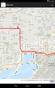
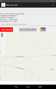
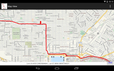
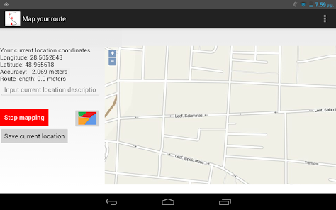
Use your GPS equipped Android device as a mapping tool for topographic surveys or just to keep tracks of your way. Through an easy to use interface you can map Locations, Routes, Points of Interest or Polygon areas suitable for professional topographic surveys. Simply enable your GPS receiver, view the coordinates and the map of your current location and start mapping. The application records the GPS tracks of your device and creates Linear, Point or Polygon features.
This application is not designed only for professional use. Use it in hiking, traveling, running and in any other occasion that you care to know when and how you got in a place and where is this place.
Mapped data may be viewed in the app on OpenStreetMap and get exported in HTML, KML and CSV compatible with most GIS and mapping software.
The exported KML files are also compatible with "WMS Map Viewer on line" a web app also available as a Chrome and Android application. Through this app KML files may be displayed as overlay to the web map of your choice.
Updated on
Safety starts with understanding how developers collect and share your data. Data privacy and security practices may vary based on your use, region, and age. The developer provided this information and may update it over time.

No data shared with third parties
Learn more about how developers declare sharing

No data collected
Learn more about how developers declare collection
Ratings and reviews
4.2
11 reviews

A Google user
- Flag inappropriate
November 9, 2016
Crash
1 person found this review helpful
What's new
Compatibility improvements.


