Allarme Meteo IT
Contains ads
100K+
Downloads

Everyone
info


About this app
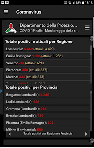
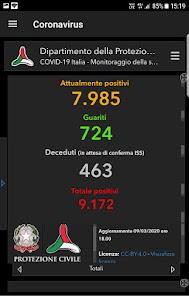
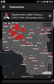
Updated bulletins, data and maps on the spread of the pandemic.
Weather Forecast - Get notified when there is a risk of floods, storms and severe thunderstorms.
Predicting them 12/24 hours in advance today is possible in 90% of cases. With the data provided by the National Civil Protection and an integrated multimedia system that allows you to keep the situation always under control in real time, Alarme Meteo IT © informs you in case of hydrogeological risk and adverse weather conditions, showing you the alarms, the map with the critical areas, the places where it is raining and the intensity.
You can share alerts via Facebook, Twitter, Whatsapp and via email to notify a friend or family member.
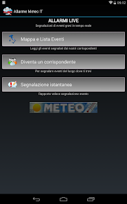
Furthermore, thanks to a system of reports from our reporters, it is possible to view, almost in real time, the areas where severe weather events have caused damage and view the photos sent in the App.
In recent years, in Italy and in the rest of the world, due to disinformation, the floods have hit hard causing considerable damage to citizens and too often to victims.
Being informed with the official data of the Italian Civil Protection - Presidency of the Council of Ministers, which is the most reliable official body in Italy and with the data available in the App that we have created, it is important to protect yourself from extreme weather events , to keep them under control, to organize, be prepared, update themselves and avoid traveling to places at risk.
Floods, increasingly frequent in Italy, are atmospheric events that today, thanks to the technologies available, are in most cases predictable and can be monitored in real time.
Main functions:
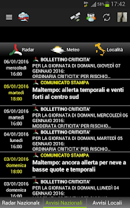
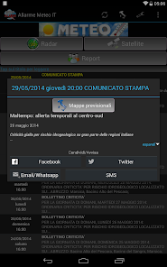
- Receipt of Criticality Bulletins of Hydrogeological Alert of Civil Protection - National
- Reception of press releases weather alert from the Civil Protection - Central Department
- Reception of Weather and Hydrogeological Alerts for other sources in case of high risk
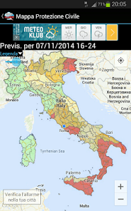
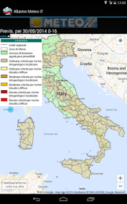
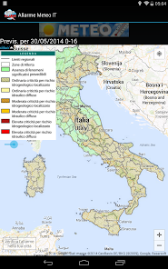
- Map of National Hydrogeological Risk Bulletins Central Functional Center - Hydro Sector
- Map of the Surveillance Bulletins - Central Functional Center - Weather Sector
- Geo-localization on national maps - Hydrogeological Risk and Weather Surveillance
- Behavioral rules of the National Civil Protection Department
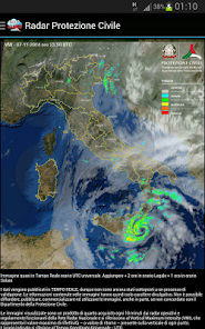
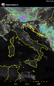
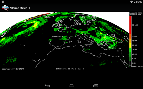
- VMI Radar Map of the Civil Protection - National Department
- National emergency numbers of official bodies
- Possibility for users to notify / share an official alert and spread it through social networks and via e-mail
- Possibility to become a correspondent
- Reports of Serious Weather Events from correspondents
- Metric geo-localization of the Reports
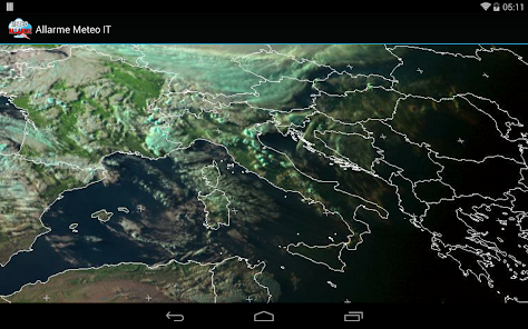
- Interactive Radar and Satellite maps
Main data source: Department of Civil Protection - Presidency of the Council of Ministers
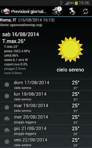
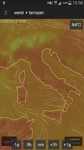
Additional integrated features such as forecasts provided by Google and Openweathermap.org and for more experienced users, radar, satellites and more.
Weather Forecast - Get notified when there is a risk of floods, storms and severe thunderstorms.
Predicting them 12/24 hours in advance today is possible in 90% of cases. With the data provided by the National Civil Protection and an integrated multimedia system that allows you to keep the situation always under control in real time, Alarme Meteo IT © informs you in case of hydrogeological risk and adverse weather conditions, showing you the alarms, the map with the critical areas, the places where it is raining and the intensity.
You can share alerts via Facebook, Twitter, Whatsapp and via email to notify a friend or family member.
Furthermore, thanks to a system of reports from our reporters, it is possible to view, almost in real time, the areas where severe weather events have caused damage and view the photos sent in the App.
In recent years, in Italy and in the rest of the world, due to disinformation, the floods have hit hard causing considerable damage to citizens and too often to victims.
Being informed with the official data of the Italian Civil Protection - Presidency of the Council of Ministers, which is the most reliable official body in Italy and with the data available in the App that we have created, it is important to protect yourself from extreme weather events , to keep them under control, to organize, be prepared, update themselves and avoid traveling to places at risk.
Floods, increasingly frequent in Italy, are atmospheric events that today, thanks to the technologies available, are in most cases predictable and can be monitored in real time.
Main functions:
- Receipt of Criticality Bulletins of Hydrogeological Alert of Civil Protection - National
- Reception of press releases weather alert from the Civil Protection - Central Department
- Reception of Weather and Hydrogeological Alerts for other sources in case of high risk
- Map of National Hydrogeological Risk Bulletins Central Functional Center - Hydro Sector
- Map of the Surveillance Bulletins - Central Functional Center - Weather Sector
- Geo-localization on national maps - Hydrogeological Risk and Weather Surveillance
- Behavioral rules of the National Civil Protection Department
- VMI Radar Map of the Civil Protection - National Department
- National emergency numbers of official bodies
- Possibility for users to notify / share an official alert and spread it through social networks and via e-mail
- Possibility to become a correspondent
- Reports of Serious Weather Events from correspondents
- Metric geo-localization of the Reports
- Interactive Radar and Satellite maps
Main data source: Department of Civil Protection - Presidency of the Council of Ministers
Additional integrated features such as forecasts provided by Google and Openweathermap.org and for more experienced users, radar, satellites and more.
Updated on
Safety starts with understanding how developers collect and share your data. Data privacy and security practices may vary based on your use, region, and age. The developer provided this information and may update it over time.


What's new
Correzione blocco notifiche su alcune versioni di Android