
Campiña Sur de Extremadura
4.6star
16 reviews
1K+
Downloads

Everyone
info


About this app
Discover La Campiña Sur de Extremadura is an application developed with the Rural Development Center "CAMPIÑA SUR", offers tourist information about this region located in the southwest of Extremadura and its 21 municipalities: Ahillones, Azuaga, Berlanga, Campillo de Llerena, Casas de Reina , Fuente del Arco, Granja de Torrehermosa, Higuera de Llerena, Llera, Llerena, Maguilla, Malcocinado, Peraleda del Zaucejo, Puebla del Maestre, Reina, Retamal de Llerena, Trasierra, Usagre, Valencia de las Torres, Valverde de Llerena and Villagarcía de tower.
The natural attractions are complemented by the historical-artistic wealth that the diverse civilizations that have populated it have left in the region: prehistoric dolmens and menhirs, Roman sites, remains of Arab constructions, churches, Mudejar and Gothic style facades as well as houses stately of the eighteenth and nineteenth centuries.
The biodiversity of animals and plants in the Campiña Sur de Extremadura is another incentive to visit this region and observe species such as the crane, bustard and a large number of some protected species such as the Iberian Imperial Eagle or the Black Stork, without forgetting the wide sample of orchids that you will find in the South Campiña.
Information about La Jayona Mine, Alcazaba de Reina, Celestial Viewpoint of La Campiña Sur or the Roman Theater of Regina, among many other treasures that the South of Extremadura Campiña hides. Are you going to miss it? ....
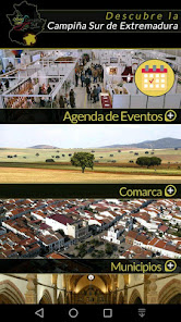
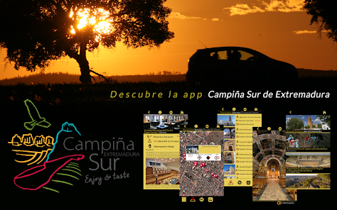
The application is divided into:
- EVENTS CALENDAR
Updated information of all the events that will be held in Campiña Sur,
You can consult it for days, weeks or months.
- COMARCA:
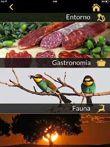
It shows information about its history, geographical situation, environment, gastronomy, fauna
and weather.
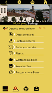
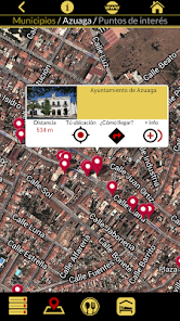
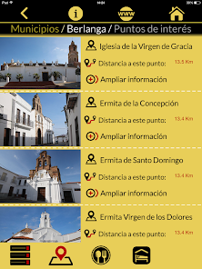
- MUNICIPALITIES:
You will access the detailed file of the 21 municipalities that make up the Campiña Sur de Extremadura, where you will know, your general information, points of interest geolocated to reach them, parties, routes, cuisine, guide bars, restaurants and accommodation.
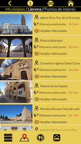
- ARTISTIC HISTORICAL HERITAGE:
Information about its historical artistic heritage, that you can know through photos and
visit them through geolocation, to reach them.
- NATURAL HERITAGE
Information about its natural heritage, showing its location to be able to visit them.
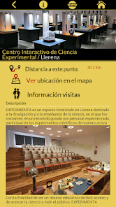
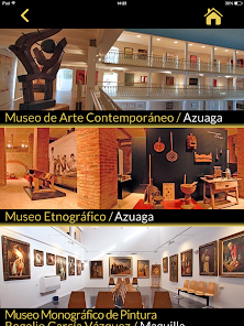
- MUSEUMS AND INTERPRETATION CENTERS
Information of its interpretation centers and museums, geolocated to visit them.
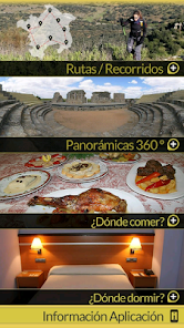
- ROUTES AND ROUTES
It proposes several routes to travel and visit the points of interest of the South Campiña.
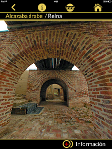
- PANORAMIC 360º
It shows panoramic photos of its monuments.
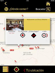
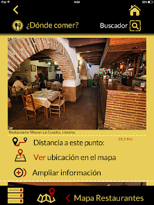
- WHERE TO EAT?
Location and information guide of the offer of Bars and Restaurants.
- WHERE TO SLEEP?
Location and information guide of the accommodation offer.
The natural attractions are complemented by the historical-artistic wealth that the diverse civilizations that have populated it have left in the region: prehistoric dolmens and menhirs, Roman sites, remains of Arab constructions, churches, Mudejar and Gothic style facades as well as houses stately of the eighteenth and nineteenth centuries.
The biodiversity of animals and plants in the Campiña Sur de Extremadura is another incentive to visit this region and observe species such as the crane, bustard and a large number of some protected species such as the Iberian Imperial Eagle or the Black Stork, without forgetting the wide sample of orchids that you will find in the South Campiña.
Information about La Jayona Mine, Alcazaba de Reina, Celestial Viewpoint of La Campiña Sur or the Roman Theater of Regina, among many other treasures that the South of Extremadura Campiña hides. Are you going to miss it? ....
The application is divided into:
- EVENTS CALENDAR
Updated information of all the events that will be held in Campiña Sur,
You can consult it for days, weeks or months.
- COMARCA:
It shows information about its history, geographical situation, environment, gastronomy, fauna
and weather.
- MUNICIPALITIES:
You will access the detailed file of the 21 municipalities that make up the Campiña Sur de Extremadura, where you will know, your general information, points of interest geolocated to reach them, parties, routes, cuisine, guide bars, restaurants and accommodation.
- ARTISTIC HISTORICAL HERITAGE:
Information about its historical artistic heritage, that you can know through photos and
visit them through geolocation, to reach them.
- NATURAL HERITAGE
Information about its natural heritage, showing its location to be able to visit them.
- MUSEUMS AND INTERPRETATION CENTERS
Information of its interpretation centers and museums, geolocated to visit them.
- ROUTES AND ROUTES
It proposes several routes to travel and visit the points of interest of the South Campiña.
- PANORAMIC 360º
It shows panoramic photos of its monuments.
- WHERE TO EAT?
Location and information guide of the offer of Bars and Restaurants.
- WHERE TO SLEEP?
Location and information guide of the accommodation offer.
Updated on
Safety starts with understanding how developers collect and share your data. Data privacy and security practices may vary based on your use, region, and age. The developer provided this information and may update it over time.

No data shared with third parties
Learn more about how developers declare sharing

No data collected
Learn more about how developers declare collection
Ratings and reviews
4.6
16 reviews
App support
phone
Phone number
+34924891160