
FieldMove Clino
4.2star
682 reviews
50K+
Downloads

Everyone
info


About this app
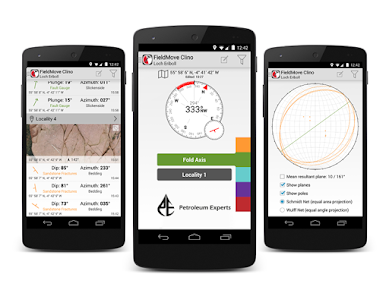
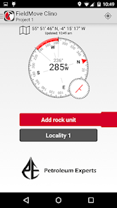
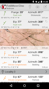
FieldMove Clino is a digital compass-clinometer for data capture on your Android phone, designed for simplicity in the field, and optimized to use the device’s GPS location and orientation sensors. This geology app will allow you to use your phone as a traditional hand-held bearing compass as well as a digital compass-clinometer for measuring and capturing the orientation of planar and linear features in the field. FieldMove Clino allows you to quickly take large amounts of measurements, making your data set much more statistically valid. You can also capture and store georeferenced digital photographs and text notes.
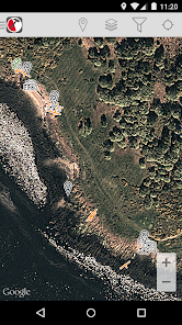
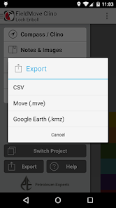
As well as supporting online Google Maps, FieldMove Clino also supports offline maps, so that you can import your own georeferenced basemaps and collect data while disconnected. Data can be exported as MOVE, CSV or KMZ files and then imported directly into FieldMove™, Move™ or other applications like Google Earth.
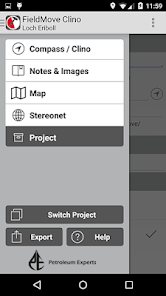
FieldMove Clino Additional Features:
-- Display geological data on an equal area or equal angle stereonet, allowing you to perform some basic statistical analysis in the field
-- A new expanded library of symbols for customisation of planar and linear features
-- Export KMZ data into Google Earth
A more in-depth guide is available here: http://www.petex.com/products/move-suite/digital-field-mapping/
NOTE: FieldMove Clino is only available for smart phones as we found this was the best form-factor for data collection. It will currently NOT run on tablet devices. Cost (as shown in the screenshots) will depend on the location of the user.
FieldMove Clino is a Petroleum Experts geological field mapping app designed for forward thinking geologists utilising digital data collection.
--------------------
The use of GPS devices and smartphones as navigation aids.
Global Positioning System (GPS) devices are commonly used to aid navigation, having grown in popularity over the past decade. Over the last few years, this has extended to smartphones and digital compasses, which are often equipped with GPS functionality.
GPS is a valuable aid to navigation during fieldwork, although it is important to keep safety at the forefront, and we draw your attention to the advice given by a number of mountaineering councils:
“Everyone heading into the hills needs to learn how to read a map, and be able to navigate effectively with a paper map and traditional magnetic compass, especially in poor visibility”.
Petroleum Experts will accept no liability or loss, resulting from the use or misuse of this product.
As well as supporting online Google Maps, FieldMove Clino also supports offline maps, so that you can import your own georeferenced basemaps and collect data while disconnected. Data can be exported as MOVE, CSV or KMZ files and then imported directly into FieldMove™, Move™ or other applications like Google Earth.
FieldMove Clino Additional Features:
-- Display geological data on an equal area or equal angle stereonet, allowing you to perform some basic statistical analysis in the field
-- A new expanded library of symbols for customisation of planar and linear features
-- Export KMZ data into Google Earth
A more in-depth guide is available here: http://www.petex.com/products/move-suite/digital-field-mapping/
NOTE: FieldMove Clino is only available for smart phones as we found this was the best form-factor for data collection. It will currently NOT run on tablet devices. Cost (as shown in the screenshots) will depend on the location of the user.
FieldMove Clino is a Petroleum Experts geological field mapping app designed for forward thinking geologists utilising digital data collection.
--------------------
The use of GPS devices and smartphones as navigation aids.
Global Positioning System (GPS) devices are commonly used to aid navigation, having grown in popularity over the past decade. Over the last few years, this has extended to smartphones and digital compasses, which are often equipped with GPS functionality.
GPS is a valuable aid to navigation during fieldwork, although it is important to keep safety at the forefront, and we draw your attention to the advice given by a number of mountaineering councils:
“Everyone heading into the hills needs to learn how to read a map, and be able to navigate effectively with a paper map and traditional magnetic compass, especially in poor visibility”.
Petroleum Experts will accept no liability or loss, resulting from the use or misuse of this product.
Updated on
Safety starts with understanding how developers collect and share your data. Data privacy and security practices may vary based on your use, region, and age. The developer provided this information and may update it over time.

No data shared with third parties
Learn more about how developers declare sharing

No data collected
Learn more about how developers declare collection

Data isn’t encrypted
Data can’t be deleted
Ratings and reviews
4.2
679 reviews

Louis
- Flag inappropriate
- Show review history
July 14, 2022
I have GPS tracking toggled on while measuring strike/dips, but when I look at the Locality map in "Notes & Images", the toggle is off! I'm always unsure whether GPS tags per Strike/Dip will be preserved as I carry my measuring session out. Workaround: screenshot each strike dip upon tapping to freeze the readout, before saving to a rock unit, to save the lat-long. RAM unloading causes me to not use the images or notes inputs in a strike/dip's details
1 person found this review helpful

Joseph Browning-Hanson
- Flag inappropriate
November 30, 2020
Decent app for on the fly fieldwork. Call me old school, but I still prefer a Brunton and a notebook for my research projects. I do appreciate the ease of access this provides for a new class of geologist (students, hobbiest, etc.) that need/want to engage in fieldwork. I also love that I can grab a measurement and jot a note while our for a casual hike. One suggestion: automatically add images of measurement screen to the export file. It would be handy for presentation materials.
4 people found this review helpful

Bobo LaDouche
- Flag inappropriate
- Show review history
August 27, 2020
Geologist here. Great GUI and simple layout, very logical. Problem with Save feature fixed, sort of. HOWEVER, save to kmz feature broken, error is "Parse error at line 10, column 0. No elerment found. Open file failed". Can hardly wait for the fix.. Strikes and dips accurate compared to Brunton compass. Ease of use will actually retire my notebook method of data and photo entry. Finally.. Program is free, and no adds. Please hurry on that update, this could be a GREAT app, best of best.
5 people found this review helpful
Petroleum Experts Limited
August 19, 2020
Thanks for the question. Clino saves all data into a current Project. By default this is called Project1. You can have several Projects and switch the active one using Switch Project button. These projects are stored on your phone in a FieldMove folder on the root of your primary external storage eg Galaxy S6\Phone\FieldMove\Projects\Project_1.fm.
What's new
• Clino Project Files device default location changed - please review the PDF Help Pages
• Base Maps on Android are now located by default in the Clino Project (.fm) folder.
• Support for Android 14 devices (API 34). Works on Android 6.0 upwards.
• Export of native Clino Project archive (.fm.zip)
• Support Android Sharing of exports (Drive, Gmail, OneDrive, WhatsApp etc.)
• Import of native Clino Project archive (.fm.zip), and Clino Project folders (.fm)
• Bug fixes