GPS Air Navigator
In-app purchases
2.9star
840 reviews
100K+
Downloads

Everyone
info


About this app
GPS Air Navigator is an application for VFR Air Navigation :: Air Nav.
Follow us on https://www.facebook.com/gpsairnavigator!
Main features:
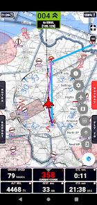
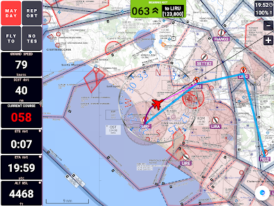
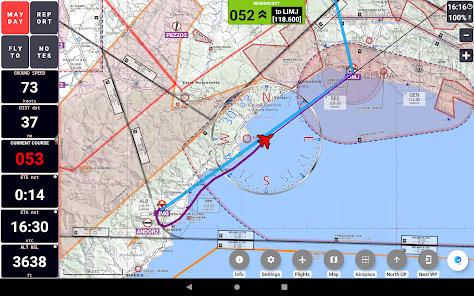
• real-time GPS moving map
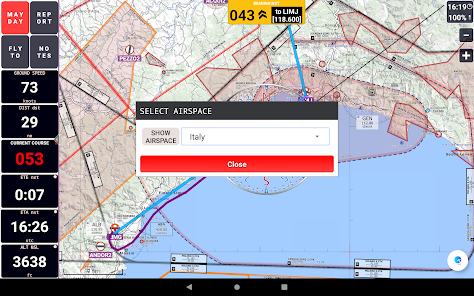
• graphical visualization of country air space
• navigation with True or Magnetic North
• High Quality VFR Aeronautical Charts (from Flyermaps.com) for Portugal, Spain, Argentina, Chile, Colombia, Iceland, Uruguay and Venezuela
• free OpenStreetMap maps for all countries
• USA Sectional VFR Charts (generated from FAA VFR Raster Charts)
• WAC and REA Charts from Brazil (thanks to DECEA-Brazil)
• free OpenFlightMaps Charts from Netherlands, Poland, Croatia, Czech Republic, Belgium, Germany, Denmark, Sweden, Bulgaria, Hungary, Slovenia, Austria, Romania and Switzerland (thanks to the Openflightmaps Association)
• airspace information for Portugal with daily updates (integrated with FuaFlex service - www.cavok.pt)
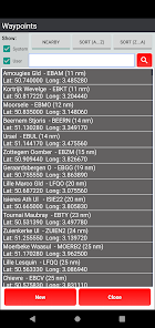
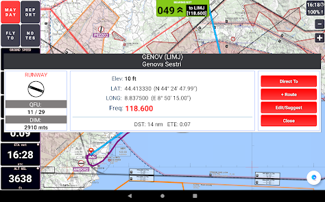
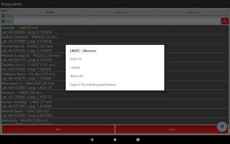
• database with more than 56.000 system waypoints
• create and manage your own user waypoints
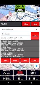
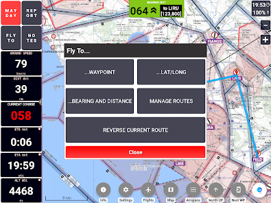
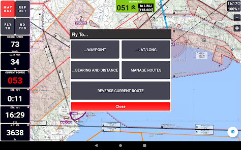
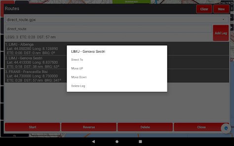
• create and manage your routes and legs
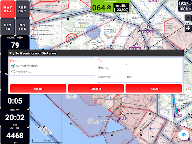
• MAYDAY button: send an automatic SMS with current location (only in devices that support this feature) and activation of a route to the nearest waypoint
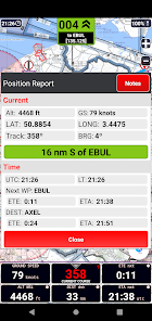
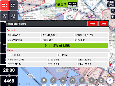
• Course with two navigation modes: a) visualization of the course you have to follow to reach the next waypoint or; b) visualization of how many degrees you have to turn to reach the next waypoint, while the arrow shows in which direction the point is in relation to the direction of your flight
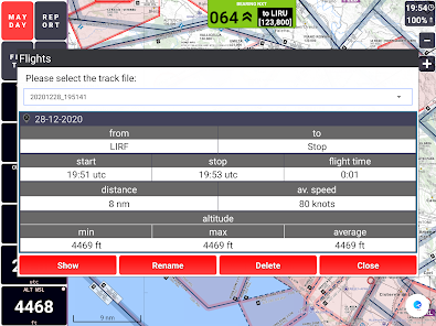
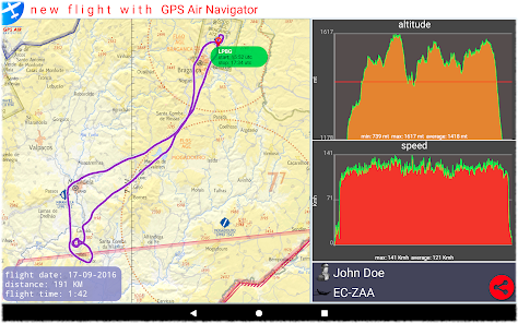
• show real-time flight tracks
• save flight tracks to a GPX file for offline processing (visualize in specific apps or inside the GPS Air Navigator)
• visualize your flight stats and share them on Facebook, e-mail, Instagram and so on
• only one licence needed for all your Android devices
After install, you can try the app with the following limitations:
• you can save only two user waypoints;
• the app closes after 15 minutes of usage.
If you like GPS Air Navigator, you can buy a licence using the button Buy inside the app, to use it without limitations.
Enjoy GPS Air Navigator!
Follow us on https://www.facebook.com/gpsairnavigator!
Main features:
• real-time GPS moving map
• graphical visualization of country air space
• navigation with True or Magnetic North
• High Quality VFR Aeronautical Charts (from Flyermaps.com) for Portugal, Spain, Argentina, Chile, Colombia, Iceland, Uruguay and Venezuela
• free OpenStreetMap maps for all countries
• USA Sectional VFR Charts (generated from FAA VFR Raster Charts)
• WAC and REA Charts from Brazil (thanks to DECEA-Brazil)
• free OpenFlightMaps Charts from Netherlands, Poland, Croatia, Czech Republic, Belgium, Germany, Denmark, Sweden, Bulgaria, Hungary, Slovenia, Austria, Romania and Switzerland (thanks to the Openflightmaps Association)
• airspace information for Portugal with daily updates (integrated with FuaFlex service - www.cavok.pt)
• database with more than 56.000 system waypoints
• create and manage your own user waypoints
• create and manage your routes and legs
• MAYDAY button: send an automatic SMS with current location (only in devices that support this feature) and activation of a route to the nearest waypoint
• Course with two navigation modes: a) visualization of the course you have to follow to reach the next waypoint or; b) visualization of how many degrees you have to turn to reach the next waypoint, while the arrow shows in which direction the point is in relation to the direction of your flight
• show real-time flight tracks
• save flight tracks to a GPX file for offline processing (visualize in specific apps or inside the GPS Air Navigator)
• visualize your flight stats and share them on Facebook, e-mail, Instagram and so on
• only one licence needed for all your Android devices
After install, you can try the app with the following limitations:
• you can save only two user waypoints;
• the app closes after 15 minutes of usage.
If you like GPS Air Navigator, you can buy a licence using the button Buy inside the app, to use it without limitations.
Enjoy GPS Air Navigator!
Updated on
Safety starts with understanding how developers collect and share your data. Data privacy and security practices may vary based on your use, region, and age. The developer provided this information and may update it over time.

No data shared with third parties
Learn more about how developers declare sharing

No data collected
Learn more about how developers declare collection
Ratings and reviews
3.0
712 reviews

A Google user
- Flag inappropriate
December 16, 2019
Lovely small app . Works all the time. The maps are a big download, I assume they are not vector. However, a good backup app. For a main use it is lacking a few features, like frequencies and airport information. The user interface is a learning curve and the VFR pilot needs to fumble with settings, not making much sense. When tipping an airport, I expect airport information, not setting a waypoint. It all relies on the openflightmaps, which is fine, but there is more data that could be displayed. After all, Communication is important. That information should be on a finger tip. good running backup map though.
26 people found this review helpful

tue kyndal
- Flag inappropriate
- Show review history
December 30, 2021
First impressions after non flying test. A few things 1. Zoom level on map is to restricted. You can not zoom in close to define a wpt on a specific location. 2. Besides the overlay compass, a navigation app without navigation aids? Where is the HSI? You need a button with a HSI for flying tracks with xvind and specific radials in/out of VORS. 3. Time and batteri on top Is to small. 4. Map constantly crash and gets distortioned Not a bad app.. I would probably buy it if you added a HSI
4 people found this review helpful
A Google user
- Flag inappropriate
- Show review history
March 4, 2020
Please improve the creation of routes. Namely when adding a new waypoint and we give it a name, create the waypoint and add it to the route. It's annoying having the route window close each time. Another thing please add the ability to paste a coordinate from Google etc instead of manually doing each field. Please add the ability to import and export way points and routes. Thanks
15 people found this review helpful
NKSoft
March 4, 2020
Dear Roy. Thanks by your comments/suggestions that we will consider with attention.
What's new
- Update of the OpenFlightMaps aeronautical charts (AIRAC 2103)
- Update of the system database of waypoints from openAIP
- Other small improvements and bug fixes
- Update of the system database of waypoints from openAIP
- Other small improvements and bug fixes


