ADK46erNow
100+
Downloads

Everyone
info


About this app
One Bad Ant's Apex App
(but hopefully not One Bad Ant's App apex!)
If you like hiking the Adirondack High Peaks, the smell of pine, the views from the high peak summits, and like gear and technology that doesn’t come between you and your hike then the ADK46erNow app is the app for you!
Whether you’re a multiple 46er, or you’re tackling your first attempt to climb the 46 high peaks then this app is for you. It is designed to be easy to use, to compliment your summit efforts, and not distract from your hike.
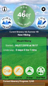
You can plan your hikes and summit attempts in advance, or, if you prefer to be spontaneous, then simply select the peak to hike and press the start button.
Once you are on the trail the ADK46erNow app provides you with a variety of tools to use - compass, GPS location, surrounding peak identifications, weather forecast, maps, and the ability to add trip notes and attach photos to your hike.
Stamp your summits by manually recording them or press a button when you reach a peak and automatically record the current time and weather forecast.
And finally share your summit plans and accomplishments including trip notes and photos with friends, family and fellow hikers via email or facebook!
Enjoy and hike responsibly!
Features:
• Compass: Tap the app logo on the home screen to reveal the compass. Tap it again to dismiss it.
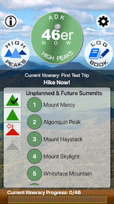
• The Progress Bar: Your summit progress bar appears at the bottom of the app’s home screen along with a count of the summits you’ve reached for your current itinerary.
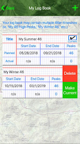
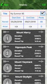
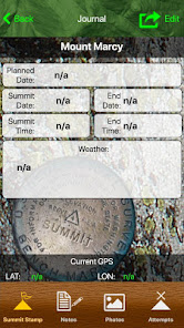
• Your Log Book: Plan an itinerary (or multiple itineraries) for summiting the 46 Adirondack high peaks. Assign planned summit dates, and automatically stamp your summits with time, date, GPS location, and current weather forecast.
• Record your hike notes and assign photos to your summits.
• As you hike, use the three “Journal” and “Info” features to locate your current position on a map and by GPS. The “360 Degree View” will identify the surrounding peaks within a five or ten mile radius.
• The Summit Stamp gives you a one-click stamp your summit achievements recording the summit date and time and weather.
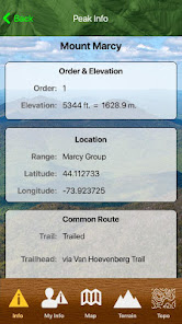
• The Peaks: Find the shortest round trip or the longest? Discover which peaks are trailed or not? Access a variety of map options including topo maps.
• And much more!
(but hopefully not One Bad Ant's App apex!)
If you like hiking the Adirondack High Peaks, the smell of pine, the views from the high peak summits, and like gear and technology that doesn’t come between you and your hike then the ADK46erNow app is the app for you!
Whether you’re a multiple 46er, or you’re tackling your first attempt to climb the 46 high peaks then this app is for you. It is designed to be easy to use, to compliment your summit efforts, and not distract from your hike.
You can plan your hikes and summit attempts in advance, or, if you prefer to be spontaneous, then simply select the peak to hike and press the start button.
Once you are on the trail the ADK46erNow app provides you with a variety of tools to use - compass, GPS location, surrounding peak identifications, weather forecast, maps, and the ability to add trip notes and attach photos to your hike.
Stamp your summits by manually recording them or press a button when you reach a peak and automatically record the current time and weather forecast.
And finally share your summit plans and accomplishments including trip notes and photos with friends, family and fellow hikers via email or facebook!
Enjoy and hike responsibly!
Features:
• Compass: Tap the app logo on the home screen to reveal the compass. Tap it again to dismiss it.
• The Progress Bar: Your summit progress bar appears at the bottom of the app’s home screen along with a count of the summits you’ve reached for your current itinerary.
• Your Log Book: Plan an itinerary (or multiple itineraries) for summiting the 46 Adirondack high peaks. Assign planned summit dates, and automatically stamp your summits with time, date, GPS location, and current weather forecast.
• Record your hike notes and assign photos to your summits.
• As you hike, use the three “Journal” and “Info” features to locate your current position on a map and by GPS. The “360 Degree View” will identify the surrounding peaks within a five or ten mile radius.
• The Summit Stamp gives you a one-click stamp your summit achievements recording the summit date and time and weather.
• The Peaks: Find the shortest round trip or the longest? Discover which peaks are trailed or not? Access a variety of map options including topo maps.
• And much more!
Updated on
Safety starts with understanding how developers collect and share your data. Data privacy and security practices may vary based on your use, region, and age. The developer provided this information and may update it over time.

No data shared with third parties
Learn more about how developers declare sharing

No data collected
Learn more about how developers declare collection
What's new
Targeting Current Android Versions.


