Mapit GIS - Map Data Collector
In-app purchases
4.0star
2.9K reviews
100K+
Downloads

Everyone
info


About this app
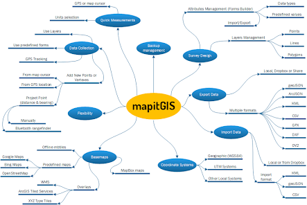
Mapit is a professional, stand-alone, cost effective mapping and surveying tool designed to enhance productivity while you are out there in the field.
The app supports common file formats for input and output and is capable to work with number of external GNSS receivers so you can get a centimetre level accuracy when you need to.
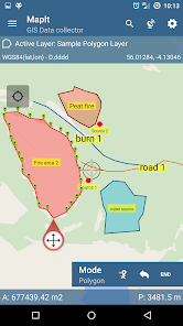
Design your survey forms, organize data on layers, work offline with mbtiles base-maps, access WMS services, use GPS tracking to capture your line and polygon features, record GNSS metadata and much more to discover.
The app is widely used by professionals around the world and can be easily adopted for different applications from agriculture and forestry to road construction, geology, land surveying and solar panel solutions. Personalized settings and flexibility makes this app fit for purpose tool which will enhance your surveying workflow.
App can be also used as a measurement tool to calculate areas or distances.
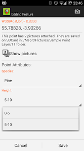
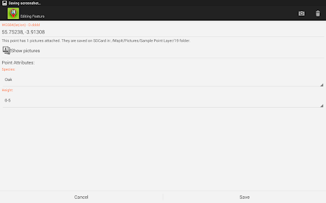
When saving location simply choose required attributes from predefined drop-down list, no need to type the same information over and over again. Import long list of attributes from text files and re-use them in number of projects. If necessary you can add pictures to each location as well.
If you are working in the field, gathering large amount of spatial data this app is designed for you.
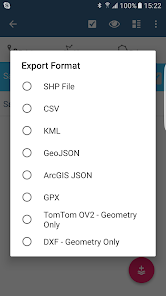
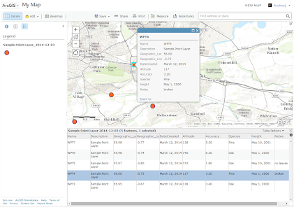
Speed up your workflow and make the data collection more efficient. Take advantage of survey layers and possibility to re-use same set of attributes for multiple surveys. Export your data to common GIS formats like Esri shapefiles, CSV, KML, geojson, DXF, GPX and post process your data using Desktop GIS software like qGIS.
Support for number of predefined coordinate systems and customised EPSG codes if required.
Mobile Data Collection Features:
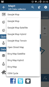
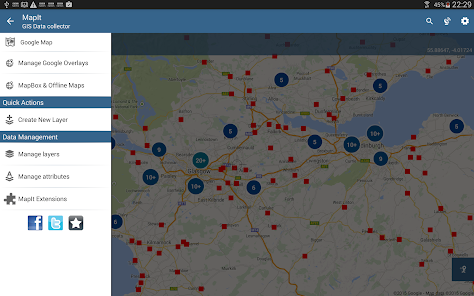
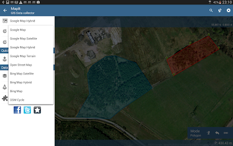
- Base maps: Popular online maps selections and offline mbtiles,
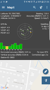
- Support for RTK corrected coordinates when external Bluetooth GPS / GNSS is connected,
- Support for WMS and GIS Server Tiled map services - load topographic and orthophoto maps, geological surveys, cadastral information and number of other services.
- Possibility to create and maintain sets of attributes - these are available as a drop down lists when new feature is being recorded, long lists of values can be imported from text files.
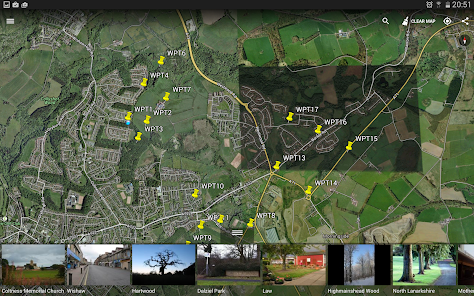
- Clusters for point map markers, efficient way of having large number of points on the map without performance issues,
- Currently 4 methods of collection are supported (GPS / GNSS location, map cursor location, tracking, point projection using angle and distance),
- Possibility to group your data into the survey layers - each survey layer may have a default set of attributes.
- Local SD card or remote export. At the moment shapefiles, KML, CSV, geojson, GPX and DXF export is supported,
- Direct export to Dropbox or FTP location
- Possibility to record multiple points, lines and polygons on one layer,
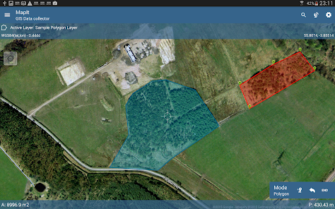
- When creating new polygon or line features measurement details like area or length are also available.
- GPS / GNSS and satellites status,
- Address, location search,
- Import point, line and polygon features into layer from CSV, KML, shapefile or geojson file,
- Backup management,
- Import/Export attributes from file and much more to discover...
Our users are successfully using Mapit in number of applications including:
- Environmental and woodland surveys,
- Forestry planning and woodland management,
- Agriculture and soil classifications and sampling,
- Road constructions,
- Land surveying,
- Solar panels applications,
- Roofing and fencing,
- Tree surveys,
- GPS and GNSS surveying,
- Site surveying
- Snow removal
Do not hesitate to contact us directly or using the contact form on our website.
The app supports common file formats for input and output and is capable to work with number of external GNSS receivers so you can get a centimetre level accuracy when you need to.
Design your survey forms, organize data on layers, work offline with mbtiles base-maps, access WMS services, use GPS tracking to capture your line and polygon features, record GNSS metadata and much more to discover.
The app is widely used by professionals around the world and can be easily adopted for different applications from agriculture and forestry to road construction, geology, land surveying and solar panel solutions. Personalized settings and flexibility makes this app fit for purpose tool which will enhance your surveying workflow.
App can be also used as a measurement tool to calculate areas or distances.
When saving location simply choose required attributes from predefined drop-down list, no need to type the same information over and over again. Import long list of attributes from text files and re-use them in number of projects. If necessary you can add pictures to each location as well.
If you are working in the field, gathering large amount of spatial data this app is designed for you.
Speed up your workflow and make the data collection more efficient. Take advantage of survey layers and possibility to re-use same set of attributes for multiple surveys. Export your data to common GIS formats like Esri shapefiles, CSV, KML, geojson, DXF, GPX and post process your data using Desktop GIS software like qGIS.
Support for number of predefined coordinate systems and customised EPSG codes if required.
Mobile Data Collection Features:
- Base maps: Popular online maps selections and offline mbtiles,
- Support for RTK corrected coordinates when external Bluetooth GPS / GNSS is connected,
- Support for WMS and GIS Server Tiled map services - load topographic and orthophoto maps, geological surveys, cadastral information and number of other services.
- Possibility to create and maintain sets of attributes - these are available as a drop down lists when new feature is being recorded, long lists of values can be imported from text files.
- Clusters for point map markers, efficient way of having large number of points on the map without performance issues,
- Currently 4 methods of collection are supported (GPS / GNSS location, map cursor location, tracking, point projection using angle and distance),
- Possibility to group your data into the survey layers - each survey layer may have a default set of attributes.
- Local SD card or remote export. At the moment shapefiles, KML, CSV, geojson, GPX and DXF export is supported,
- Direct export to Dropbox or FTP location
- Possibility to record multiple points, lines and polygons on one layer,
- When creating new polygon or line features measurement details like area or length are also available.
- GPS / GNSS and satellites status,
- Address, location search,
- Import point, line and polygon features into layer from CSV, KML, shapefile or geojson file,
- Backup management,
- Import/Export attributes from file and much more to discover...
Our users are successfully using Mapit in number of applications including:
- Environmental and woodland surveys,
- Forestry planning and woodland management,
- Agriculture and soil classifications and sampling,
- Road constructions,
- Land surveying,
- Solar panels applications,
- Roofing and fencing,
- Tree surveys,
- GPS and GNSS surveying,
- Site surveying
- Snow removal
Do not hesitate to contact us directly or using the contact form on our website.
Updated on
Safety starts with understanding how developers collect and share your data. Data privacy and security practices may vary based on your use, region, and age. The developer provided this information and may update it over time.

No data shared with third parties
Learn more about how developers declare sharing

No data collected
Learn more about how developers declare collection
Ratings and reviews
4.0
2.64K reviews

A Google user
- Flag inappropriate
March 9, 2019
i would like a refund. waste of $15 for me. Maybe not a bad app for collecting data, but import functionality is quite limited. i purchased because it claimed to be able to import esri shape files. though that is partially true, i found that it can only import the most basic shape files with few points correctly. any polys with larger point counts or cutout areas within the poly do not import correctly, so it is of no use to me.
46 people found this review helpful
A Google user
- Flag inappropriate
- Show review history
January 4, 2019
If you are happy to only have your data on your phone it's probably OK. But if you actually want to use it to make a map on your computer you have the upgrade to the pro version. Without that functionality it's absolutely useless. Devs should be up front about limitations on the free version so I don't waste my time on an app that "can" do what I need but doesn't.
52 people found this review helpful

Peter Wambuki
- Flag inappropriate
March 11, 2021
Frustrating to be told to keep repurchasing the pro extension daily despite owning .Recent updates are so frustrating. You could be in an extremely remote area without network access and boom the app suddenly tells you need to buy a pro extension to access database management feature despite having bought one prior. No change of phone no change of anything and it costs you travelling to a network area to "try" repurchasing only to be told "error! You already own this item" 😡😡 So frustrating!!
25 people found this review helpful
What's new
FIX: Issue with Accuracy as HRMS reading. When connected to external GNSS this function was not working as expected.
FIX: Accuracy was always exported as HRMS when HRMS was available which was not expected behaviour.
FIX: Other minor bug fixes.
FIX: Accuracy was always exported as HRMS when HRMS was available which was not expected behaviour.
FIX: Other minor bug fixes.


