
PPGpS Lite

2.9star
202 reviews
10K+
Downloads

Everyone
info


About this app
Flight Computer for Paramotor, Paraglider, Glider and Ultra Light plane Pilots
Welcome to PPGpS, a Flight Computer for Paramotor, Paraglider, Glider and Ultra Light plane Pilots
*WARNING there are missing features in the Lite version:
-Log flights in KML/IGC format
-Waypoints management
-Airspace display
-QNH/QFE altimeter setting
-Android Wear smartwatches via PPGpS Wear compatibility
-The annoying popups are removed in the Full version
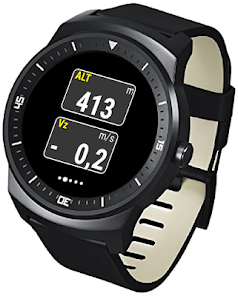
-Display instruments on your Android Wear SmartWatch
*FEATURES OVERVIEW:
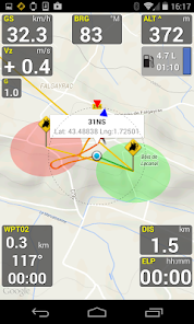
-Real time flight information
-Wind direction and speed estimation
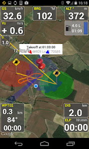
-Takeoff and Landing phases auto-detection
-Return home information (display estimated travel time and bearing)
-Fuel calculation and warning
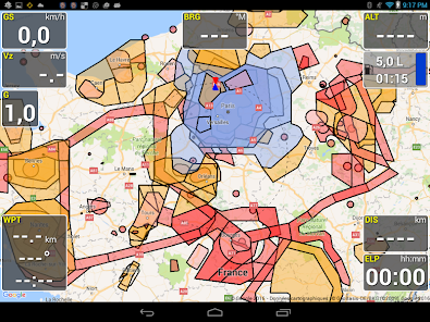
-Airspace display (OpenAir files)
-Emergency geo-localized SMS
-Localization with GPS
-Barometric sensor support to improve altitude accuracy
-QHN, QFE Altimeter setting
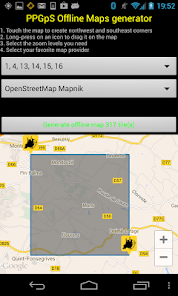
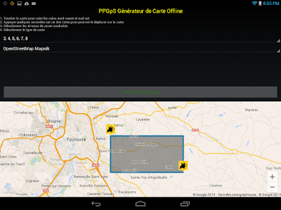
-Online and offline maps
-Offline maps creator
-Google Maps and OpenStreetMap map providers
-Rotating Map
-Log flights in KML (for Google Earth), IGC (Leonardo servers) and GPX files
-Replay recorded flights
-Waypoint management
-Especially developed for Paramotor
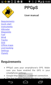
-Embedded User Manual and Tip of the day feature.
-Real time flight tracking on www.ppgps.info
-Variometer
-Sunset time
-FlyNet2, Flight Bandit, BlueFlyVario variometer support
-Android Wear SmartWatch support with PPGpS Wear
*MAPS:
Online:
PPGpS can display Google or OpenStreetMap maps in connected mode.
Offline:
Download map files in your smartphone in case you don't have an internet connection during the flight.
Use the integrated PPGpS Offline Map Creator to generate offline maps.
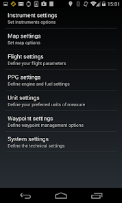
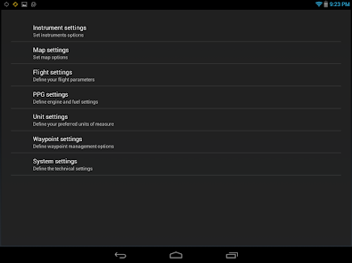
*INSTRUMENTS:
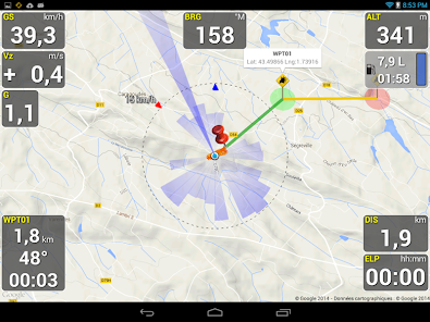
PPGpS provides the altitude, vario, bearing, magnetic compass, acceleration and ground speed.
With just one click on instruments you switch easily between different data modes : instantaneous, average and maximum values.
Altimeter can be set to actual altitude or elevation (QHN, QFE) just by long-pressing on the altimeter.
If your smartphone has a barometric sensor, it could be used to compute a very accurate altitude.
You can use PPGpS Wear companion application to display your instruments on your SmartWatch.
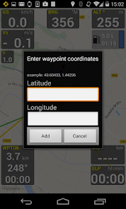
*WAYPOINTS:
Create waypoints by tapping on the map or by entering their GPS coordinates.
Select a waypoint with one click on the waypoint instrument (WPT).
Rename or remove a waypoint from the contextual menu of the waypoint list.
Follow the displayed route (bearing, estimated travel time and distance).
Prepare your waypoints from Google Earth and import your KML files (PPGpS folder in the phone).
Waypoints may be automatically loaded at startup and saved at the end of the session.
In case your KML file doesn't import well, please send me the file and I will fix it quickly.
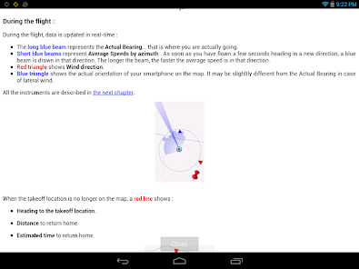
*WIND AND SPEEDS HUD:
The average ground speeds are graphically displayed for every azimuth.
The wind direction is displayed (red arrow) and may be reset at any time during the flight.
*RETURN HOME:
Home direction and Estimated Travel Time to return home is always displayed (shaded red line).
Computations are done according to the wind for accurate results.
*LIVE TRACKING:
Enable the Live Tracking feature to allow your friends and family to see you live on map ! Go to www.ppgps.info for more details.
*AIRSPACE:
Copy OpenAir files in the /ppgps/airspace folder to display airspaces on top of the map
Use my other app AirspaceMap to help you download and customize your openAir files
https://play.google.com/store/apps/details?id=com.ns31.airspacemap
Launch the Demonstration mode to have a quick tour.
Visit http://www.ppgps.info
Find us on Facebook : https://www.facebook.com/ppgps
and Twitter : https://twitter.com/PPGpSAndroid
Enjoy your flights with PPGpS and thank you for your feedback.
Don't hesitate to send me your kml flight logs by mail : stephane.nicole31@gmail.com
Welcome to PPGpS, a Flight Computer for Paramotor, Paraglider, Glider and Ultra Light plane Pilots
*WARNING there are missing features in the Lite version:
-Log flights in KML/IGC format
-Waypoints management
-Airspace display
-QNH/QFE altimeter setting
-Android Wear smartwatches via PPGpS Wear compatibility
-The annoying popups are removed in the Full version
-Display instruments on your Android Wear SmartWatch
*FEATURES OVERVIEW:
-Real time flight information
-Wind direction and speed estimation
-Takeoff and Landing phases auto-detection
-Return home information (display estimated travel time and bearing)
-Fuel calculation and warning
-Airspace display (OpenAir files)
-Emergency geo-localized SMS
-Localization with GPS
-Barometric sensor support to improve altitude accuracy
-QHN, QFE Altimeter setting
-Online and offline maps
-Offline maps creator
-Google Maps and OpenStreetMap map providers
-Rotating Map
-Log flights in KML (for Google Earth), IGC (Leonardo servers) and GPX files
-Replay recorded flights
-Waypoint management
-Especially developed for Paramotor
-Embedded User Manual and Tip of the day feature.
-Real time flight tracking on www.ppgps.info
-Variometer
-Sunset time
-FlyNet2, Flight Bandit, BlueFlyVario variometer support
-Android Wear SmartWatch support with PPGpS Wear
*MAPS:
Online:
PPGpS can display Google or OpenStreetMap maps in connected mode.
Offline:
Download map files in your smartphone in case you don't have an internet connection during the flight.
Use the integrated PPGpS Offline Map Creator to generate offline maps.
*INSTRUMENTS:
PPGpS provides the altitude, vario, bearing, magnetic compass, acceleration and ground speed.
With just one click on instruments you switch easily between different data modes : instantaneous, average and maximum values.
Altimeter can be set to actual altitude or elevation (QHN, QFE) just by long-pressing on the altimeter.
If your smartphone has a barometric sensor, it could be used to compute a very accurate altitude.
You can use PPGpS Wear companion application to display your instruments on your SmartWatch.
*WAYPOINTS:
Create waypoints by tapping on the map or by entering their GPS coordinates.
Select a waypoint with one click on the waypoint instrument (WPT).
Rename or remove a waypoint from the contextual menu of the waypoint list.
Follow the displayed route (bearing, estimated travel time and distance).
Prepare your waypoints from Google Earth and import your KML files (PPGpS folder in the phone).
Waypoints may be automatically loaded at startup and saved at the end of the session.
In case your KML file doesn't import well, please send me the file and I will fix it quickly.
*WIND AND SPEEDS HUD:
The average ground speeds are graphically displayed for every azimuth.
The wind direction is displayed (red arrow) and may be reset at any time during the flight.
*RETURN HOME:
Home direction and Estimated Travel Time to return home is always displayed (shaded red line).
Computations are done according to the wind for accurate results.
*LIVE TRACKING:
Enable the Live Tracking feature to allow your friends and family to see you live on map ! Go to www.ppgps.info for more details.
*AIRSPACE:
Copy OpenAir files in the /ppgps/airspace folder to display airspaces on top of the map
Use my other app AirspaceMap to help you download and customize your openAir files
https://play.google.com/store/apps/details?id=com.ns31.airspacemap
Launch the Demonstration mode to have a quick tour.
Visit http://www.ppgps.info
Find us on Facebook : https://www.facebook.com/ppgps
and Twitter : https://twitter.com/PPGpSAndroid
Enjoy your flights with PPGpS and thank you for your feedback.
Don't hesitate to send me your kml flight logs by mail : stephane.nicole31@gmail.com
Updated on
Safety starts with understanding how developers collect and share your data. Data privacy and security practices may vary based on your use, region, and age. The developer provided this information and may update it over time.

No data shared with third parties
Learn more about how developers declare sharing

No data collected
Learn more about how developers declare collection
Ratings and reviews
3.0
186 reviews

Garras Porgratix
- Flag inappropriate
- Show review history
June 14, 2020
Every 2 mins or so you have to press back button to remove pester box to upgrade to full version. Not a whole lot of time to look for other features and try them. Free version not really useful as youll probably fumble the phone in mid air.
4 people found this review helpful

A Google user
- Flag inappropriate
- Show review history
November 24, 2018
Purchased full version but refunded immediately. Downloaded airspace but it does not show the heights of airspace, so useless than. I fly under class b and NEED to know what my limits are without having to open another app. Goodbye.
9 people found this review helpful

Jose Rafols
- Flag inappropriate
January 9, 2021
Purchased full version. Great app if it didn't kept crashing multiple times throughout the flight. Might have to get an iphone just so I can switch to flyskyhy
2 people found this review helpful
What's new
1.59a 05/2021
Support generic LK8Ex1 protocol for bluetooth altivarios
Timestamps in KML track files for better replay
Bug fix on Replay
Bug fix on Tip of the day
1.58 04/2021
Italian translation completed
Airspace file parsing improved
File security issue with Android 11 fixed
1.57 04/2021
Input Map and Waypoint name fixed
Elevation above ground crash fix
1.56 09/2020
Floating text color configurable
Lock the screen in portrait, landscape and inverted