RipCharts
In-app purchases
4.5star
186 reviews
10K+
Downloads

Everyone
info


About this app
Welcome to RipCharts - The industry leader in satellite fishing maps. This app is free to download for existing RipCharts Premium subscribers. If you are new to RipCharts, then we allow you to purchase a new RipCharts subscription via an In-App-Purchase. Please contact us if you have questions or would like a complementary demo. (http://www.ripcharts.com)
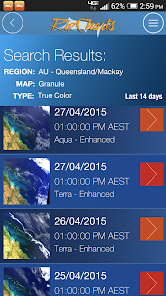
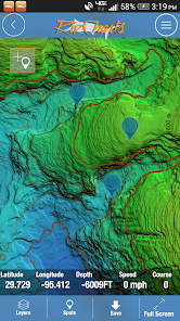
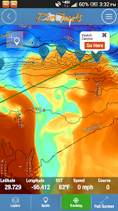
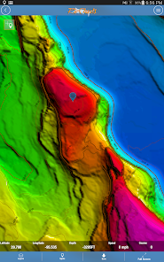
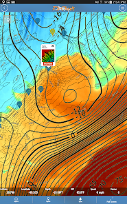
The RipCharts mobile app is a powerful tool that enables offshore fishermen to evaluate recent satellite imagery in order to determine favorable fishing conditions. Search for, view, and download maps of near-realtime satellite imagery onto your device to take with you offshore.
View the latest imagery datasets:
- Raw SST orbit scans
- Composite SST (1day,3day)
- Multi-Res/Cloud Free SST
- Sub-surface SST (0m, -25m, -50m, -100m)
- 5 day SST forecast models
- Chlorophyll
- Chlorophyll/Cloud mashups
- Chlorophyll composites
- True Color
- Altimetry
- Currents
- Salinity
- Bathymetry
Map Features:
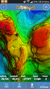
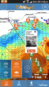
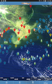
Use the multi-touch map to zoom, pan, view waypoints, and overlay additional data layers to gain insight into where the most favorable fishing zones are located.
Mapping Tools:
- Measure distances and headings between points
- Dynamically customize temp/color ranges on SST maps to identify subtle breaks <-- powerful feature!
- Overlay bathymetry, altimetry, currents, and Loran layers
- Tap the map to receive point information (lat, lon, depth, SST)
- Popular waypoints and fishing hotspots come pre-loaded
- Manage your personal waypoints (add,edit,delete)
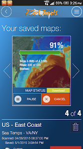
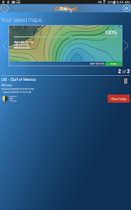
- Save imagery to your device for offline/offshore use
- Show your position and navigate on saved imagery using GPS satellites
- "Go Here" navigation with bearing, ETA, and speed displays
- Floater oil rig positions updated twice daily (Gulf of Mexico only)
The RipCharts mobile app is a powerful tool that enables offshore fishermen to evaluate recent satellite imagery in order to determine favorable fishing conditions. Search for, view, and download maps of near-realtime satellite imagery onto your device to take with you offshore.
View the latest imagery datasets:
- Raw SST orbit scans
- Composite SST (1day,3day)
- Multi-Res/Cloud Free SST
- Sub-surface SST (0m, -25m, -50m, -100m)
- 5 day SST forecast models
- Chlorophyll
- Chlorophyll/Cloud mashups
- Chlorophyll composites
- True Color
- Altimetry
- Currents
- Salinity
- Bathymetry
Map Features:
Use the multi-touch map to zoom, pan, view waypoints, and overlay additional data layers to gain insight into where the most favorable fishing zones are located.
Mapping Tools:
- Measure distances and headings between points
- Dynamically customize temp/color ranges on SST maps to identify subtle breaks <-- powerful feature!
- Overlay bathymetry, altimetry, currents, and Loran layers
- Tap the map to receive point information (lat, lon, depth, SST)
- Popular waypoints and fishing hotspots come pre-loaded
- Manage your personal waypoints (add,edit,delete)
- Save imagery to your device for offline/offshore use
- Show your position and navigate on saved imagery using GPS satellites
- "Go Here" navigation with bearing, ETA, and speed displays
- Floater oil rig positions updated twice daily (Gulf of Mexico only)
Updated on
Safety starts with understanding how developers collect and share your data. Data privacy and security practices may vary based on your use, region, and age. The developer provided this information and may update it over time.

No data shared with third parties
Learn more about how developers declare sharing

This app may collect these data types
Personal info, App info and performance, and Device or other IDs

Data isn’t encrypted

You can request that data be deleted
Ratings and reviews
4.4
179 reviews

A Google user
- Flag inappropriate
October 8, 2019
Has been great up until a few months ago. Used this app as a private Capt for years but app will not open correctly, randomly closing, halfway missing screens. For the $ you'd expect it o work better than it has been.
9 people found this review helpful
A Google user
- Flag inappropriate
February 17, 2019
This ap offers some real next-level information! we use it for tracking conditions for swordfish in the Gulf of Mexico and find it absolutely invaluable. Turbidity/chlorophyll levels are critical and impossible to find in even on the interent... having an ap that provides that in the palm of your hand is amazing. can not speak highly enough of this amazing product. kudos gentlemen.
19 people found this review helpful
A Google user
- Flag inappropriate
- Show review history
December 4, 2019
Be good if you disclose the cost of maps (at least an indication) prior to downloading the app. Can't reply to your reply... doesn't state value of in app purchases. Just the generic "in app purchases available" statement
9 people found this review helpful
RipCharts
December 4, 2019
Hello, The RipCharts app description explains that In App Purchases are available for [$169 USD].
Simply read the app information to observe these details.
What's new
Updated Android Libraries