
mew-ti
3.3star
563 reviews
100K+
Downloads

Everyone
info


About this app
Features and purpose of this app
・This app provides road traffic information content exclusively for the Shuto Expressway using smartphone-specific touch operations and GPS linkage, in order to "drive (and use) the Shuto Expressway wisely."
・The content is divided into current and past information, and the purpose is to use this information to help you avoid congested sections and times of the Shuto Expressway, and make your journey smooth.
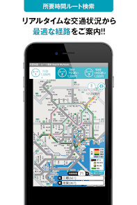
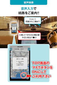
・Real-time route search on the Metropolitan Expressway (GPS linked)
Using GPS, you can see the shortest route and required time from your current location (nearest entrance/exit) to your selected destination.
*Added from H26.10.19.
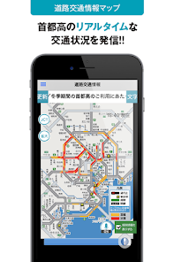
・Road traffic information
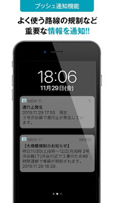
Use the scroll bar or button to view event-regulated traffic congestion information for the past 2 hours in 5-minute increments.
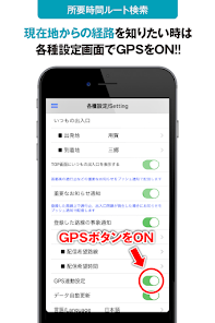
・Required time information
After setting the GPS function, the required time from the entrance, PA and JCT to the destination will be displayed according to the current location. You can also display routes all at once on a map and compare the required time.
・Crowdness level calendar
Click the date button on the calendar to see the event regulation traffic information for last year's actual date.
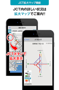
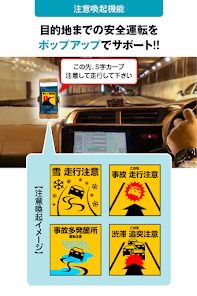
・Accident-prone spot map
Indicates the location of locations where many accidents occur on the Metropolitan Expressway (curves, junctions, main line toll gates, etc.).
・PA information
This shows the location of the PA within the Metropolitan Expressway.
■Notes
・According to the Road Traffic Act, use while the driver is driving is prohibited. Please use it with a passenger or park in a safe place.
・This application cannot be used in an environment where the Internet cannot be connected.
■Recommended environment
Android OS 6.0 or higher
*It may not work properly on some models.
*Target roads are the Metropolitan Expressway.
・This app provides road traffic information content exclusively for the Shuto Expressway using smartphone-specific touch operations and GPS linkage, in order to "drive (and use) the Shuto Expressway wisely."
・The content is divided into current and past information, and the purpose is to use this information to help you avoid congested sections and times of the Shuto Expressway, and make your journey smooth.
・Real-time route search on the Metropolitan Expressway (GPS linked)
Using GPS, you can see the shortest route and required time from your current location (nearest entrance/exit) to your selected destination.
*Added from H26.10.19.
・Road traffic information
Use the scroll bar or button to view event-regulated traffic congestion information for the past 2 hours in 5-minute increments.
・Required time information
After setting the GPS function, the required time from the entrance, PA and JCT to the destination will be displayed according to the current location. You can also display routes all at once on a map and compare the required time.
・Crowdness level calendar
Click the date button on the calendar to see the event regulation traffic information for last year's actual date.
・Accident-prone spot map
Indicates the location of locations where many accidents occur on the Metropolitan Expressway (curves, junctions, main line toll gates, etc.).
・PA information
This shows the location of the PA within the Metropolitan Expressway.
■Notes
・According to the Road Traffic Act, use while the driver is driving is prohibited. Please use it with a passenger or park in a safe place.
・This application cannot be used in an environment where the Internet cannot be connected.
■Recommended environment
Android OS 6.0 or higher
*It may not work properly on some models.
*Target roads are the Metropolitan Expressway.
Updated on
Safety starts with understanding how developers collect and share your data. Data privacy and security practices may vary based on your use, region, and age. The developer provided this information and may update it over time.

No data shared with third parties
Learn more about how developers declare sharing

This app may collect these data types
Location and Personal info

Data is encrypted in transit

Data can’t be deleted
Ratings and reviews
3.3
563 reviews
What's new
・過去2時間前から現在までの交通状況が確認可能なスライダーバー機能を、道路交通情報マップ画面左部「過去」ボタンから利用可能に改修しました。