easyAIS
4.5star
206 reviews
50K+
Downloads

Everyone
info
About this app
“easyAIS” is a free AIS real-time vessel positioning tool designed for the use on AIS receivers with WiFi connectifity.
The Automatic Identification System (AIS) is a maritime transponder/receiver system defined by the IMO (International Maritime Organisation).
AIS main objectives are to improve maritime safety and to protect the maritime environment.
Practically, AIS
•assists collision avoidance (AIS ship-to-ship)
•enables ports and coastal states to identify ships and to manage and supervise the traffic in their waters (AIS Coast station, VTS)
•helps to resolve the difficulty of identifying ships when not in sight (e.g. at night, in radar blind arcs or shadows or at distance)
By means of special VHF transceiver cruise data will be exchanged in short terms automatically. The treatment has a worldwide standard and runs every where. So vessels who use AIS devices from different companies will „see“ each other.
AIS enables to view over obstacles and complements radar. Acording to the antenna instalation hight an AIS station has got a transmission range about 20 to 30 nautical miles.
With the “easyAIS” app by the Weatherdock AG, all AIS targets within range are displayed relative to the user's position.
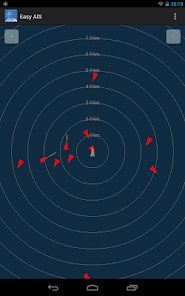
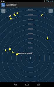
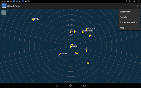
Main screen after starting the app is a virtual radar screen showing the AIS targets in relative position to you
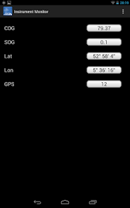
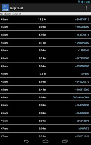
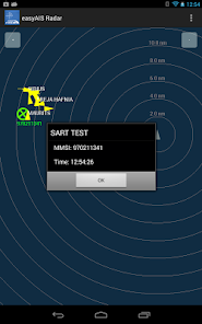
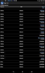
Just tapping the screen on an AIS target brings you to a list with all transmitted details of this target, e.g. GPS position, corse over ground, speed over ground, ship name, call sign, length, width, draft, port of registration …
“easyAIS” works by getting AIS data via WiFi from the AIS receiver or transceiver aboard. Without a running AIS
Notice:
“easyAIS” should not be used for navigational purposes!
The Automatic Identification System (AIS) is a maritime transponder/receiver system defined by the IMO (International Maritime Organisation).
AIS main objectives are to improve maritime safety and to protect the maritime environment.
Practically, AIS
•assists collision avoidance (AIS ship-to-ship)
•enables ports and coastal states to identify ships and to manage and supervise the traffic in their waters (AIS Coast station, VTS)
•helps to resolve the difficulty of identifying ships when not in sight (e.g. at night, in radar blind arcs or shadows or at distance)
By means of special VHF transceiver cruise data will be exchanged in short terms automatically. The treatment has a worldwide standard and runs every where. So vessels who use AIS devices from different companies will „see“ each other.
AIS enables to view over obstacles and complements radar. Acording to the antenna instalation hight an AIS station has got a transmission range about 20 to 30 nautical miles.
With the “easyAIS” app by the Weatherdock AG, all AIS targets within range are displayed relative to the user's position.
Main screen after starting the app is a virtual radar screen showing the AIS targets in relative position to you
Just tapping the screen on an AIS target brings you to a list with all transmitted details of this target, e.g. GPS position, corse over ground, speed over ground, ship name, call sign, length, width, draft, port of registration …
“easyAIS” works by getting AIS data via WiFi from the AIS receiver or transceiver aboard. Without a running AIS
Notice:
“easyAIS” should not be used for navigational purposes!
Updated on
Safety starts with understanding how developers collect and share your data. Data privacy and security practices may vary based on your use, region, and age. The developer provided this information and may update it over time.

No data shared with third parties
Learn more about how developers declare sharing

No data collected
Learn more about how developers declare collection
Ratings and reviews
4.5
173 reviews

Christophe Mouze
- Flag inappropriate
December 24, 2021
Could be useful if it was updated, but now more than 6 years old.
1 person found this review helpful

A Google user
- Flag inappropriate
- Show review history
September 19, 2018
Clear ais targets
7 people found this review helpful
A Google user
- Flag inappropriate
October 14, 2014
No closest point of approach calculations. No tcpa. No cpa alarm. No cpa vectors. The whole point of ais is cpa so from a nautical point of view the app is useless, just a toy. I have mentioned this to the developer but to no avail. Captain Ian Engelbrecht - Worldwide Yacht Deliveries
31 people found this review helpful
Stentec
October 11, 2014
Tht's correct Ian. easyAIS is mernat to be used for testing na AIS transponder. But we did listen. Our new WinGPS Marine or Marine Plus app. Both show the speed vectors of AIS targets within CPA range relative to your own SOG. Ideal to support sight navigation. See the WinGPS Marine (Plus) screenshots in Google Play.
What's new
12/8
- Running more stable.
- Minor bufixes.
22/7
- Bugfix on TCP Settings screen freezing.
15/7
- SART Targets are now clickable. Test-SART apears as green.
- AIS Target color selection. Default set to yellow.
- Running more stable.
- Minor bufixes.
22/7
- Bugfix on TCP Settings screen freezing.
15/7
- SART Targets are now clickable. Test-SART apears as green.
- AIS Target color selection. Default set to yellow.


