Coordinate Converter Plus
Contains adsIn-app purchases
4.2star
528 reviews
100K+
Downloads

Everyone
info
About this app
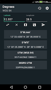
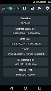
Coordinate Converter Plus is a coordinate converter and elevation calculator for Android. Supported coordinate formats:
1 Latitude / Longitude:
- Decimal degrees (DD.ddd)
- Degrees decimal minutes (DD.mmm)
- Degrees Minutes Seconds (DD MM SS)
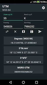
2 UTM
3 MGRS UTM.
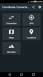
Features:
GPS converter
Latitude Longitude Converter
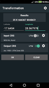
UTM(WGS84 and ARC 1950) converter
MGRS converter
Datum transformation
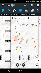
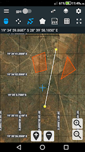
Maps
Convert map coordinates
Map layers (point, polyline, polygon)
Feature labels
Import / Export layers
Map grid with various coordinates formats (xy axis)
Calculate segment length for polylines and polygons
Calculate polygon area
Calculate distance and bearing on map
Digitizer
Create map projects
Auto save projects
Share projects
Share coordinates
Import / export coordinates
Save location
Paste coordinates from clipboard
Import / export coordinates
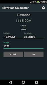
Elevation calculator
Geoid altitude correction using the EGM96 model
Possible uses:
- Mapping
- Geo-caching
- Hiking
- Camping
- Navigation
- Air rescue
- Surveys
1 Latitude / Longitude:
- Decimal degrees (DD.ddd)
- Degrees decimal minutes (DD.mmm)
- Degrees Minutes Seconds (DD MM SS)
2 UTM
3 MGRS UTM.
Features:
GPS converter
Latitude Longitude Converter
UTM(WGS84 and ARC 1950) converter
MGRS converter
Datum transformation
Maps
Convert map coordinates
Map layers (point, polyline, polygon)
Feature labels
Import / Export layers
Map grid with various coordinates formats (xy axis)
Calculate segment length for polylines and polygons
Calculate polygon area
Calculate distance and bearing on map
Digitizer
Create map projects
Auto save projects
Share projects
Share coordinates
Import / export coordinates
Save location
Paste coordinates from clipboard
Import / export coordinates
Elevation calculator
Geoid altitude correction using the EGM96 model
Possible uses:
- Mapping
- Geo-caching
- Hiking
- Camping
- Navigation
- Air rescue
- Surveys
Updated on
Safety starts with understanding how developers collect and share your data. Data privacy and security practices may vary based on your use, region, and age. The developer provided this information and may update it over time.


Ratings and reviews
4.2
508 reviews

A Google user
- Flag inappropriate
April 14, 2019
I am delighted to find this application maps coordinates down to 1m. As Search and Rescue (SAR), being able to map a location that fine is invaluable in search and recovery. If you receive coordinates, you can put them into the converter and it will convert them. Then you click the "map" icon, and it will plot it on the map. I can provide the converted coordinates to those with older GPS and in whatever format they use. It also converts the military grid system and UTM. I had to down-grade it to average, because as soon as I put my phone in airplane mode, it would not load the map. I have my county and its adjacent counties downloaded and available offline. In our huge and rural counties, you are often out of any cell comms range. It does NOT work OFFLINE even though Google maps has a download offline. I am disappointed.
22 people found this review helpful
Tennyson Chingombe
February 9, 2020
Thank you for the feedback. Please try the latest version and let me know how it goes.

Curt Williams
- Flag inappropriate
March 6, 2022
I am a SAR Team Leader. I find the app very easy to use. We typically get coordinates for search and rescue in one of the five different coordinate systems and they typically tell us where to go to meet someone or to find an objective. Therein lies the rub, it's nearly impossible to keep up with going between each of the coordinate systems to find out either where you are or where you're going. This makes it easier to perform our search and rescue task.
6 people found this review helpful
Tennyson Chingombe
March 8, 2022
Excellent. Thank you.
A Google user
- Flag inappropriate
September 17, 2019
Excellent! This app is exactly what I was looking for. Easy to use, very reliable. A little suggestion: When the convert button is hit the keyboard should close. This would make the data hidden under the keyboard easy to read without taking it down by pressing the down arrow on the keyboard.
7 people found this review helpful
Tennyson Chingombe
October 11, 2019
Thank you for the feedback. Please try this beta version and let me know how it goes
https://play.google.com/apps/testing/com.tennyson.degrees2utm
What's new
Added area calculations in decimal degrees and UTM.
Added option to add custom field labels for saving location information.
Share location.
Save, view, delete conversion history.
Calculate center coordinates for any layer type.
Added more datums and projections.
Added function to add holes to polygons.
Bug fixes
Added option to add custom field labels for saving location information.
Share location.
Save, view, delete conversion history.
Calculate center coordinates for any layer type.
Added more datums and projections.
Added function to add holes to polygons.
Bug fixes