Online Live Ship AIS Monitor
Contains ads
3.5star
112 reviews
10K+
Downloads

Everyone
info


About this app
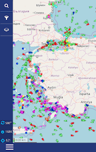
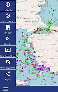
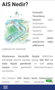
This is online live ship monitoring system based on AIS (Automatic Identification System) for all seas.
GemiTrafik.com's goal is to online live monitoring ships for amateur seafarers and sea enthusiasts for FREE.
GemiTrafik.com is a Turkish partipiciant of the international AIS projects. AIS signals are collected by amateur AIS receiver stations all over the world and sent to main servers, the signals processed there are processed on a map and presented for users via GemiTrafik.com and similar sites.
The coverage of the AIS systems may vary widely depending on the environmental conditions and location in which the receiving station is located, the antenna height and the quality of the electronic equipment.
The coverage of an average terrestrial AIS receiver station may be in the range of 15-20 Nautical miles (25-35km). An antenna height good and well-equipped station can provide coverage up to 60-70 Nautical Miles (110-130km) radius.
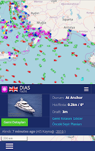
The AIS receiver stations that collect information from the sea and the vessels are all internally connected systems 24/7. They transmit all AIS data they collect in their territories to the main servers from the internet. This information will be processed from here and shaped to be seen on google maps, and it will be published via web sites again. All this takes a few seconds from the time the gathers publish their own information via the AIS system. Of course there can always be infrastructure-induced delays. When you click on the icon of a vessel you will see a small window that will tell you how many minutes ago the information was taken from that vessel.
As GemiTrafik.com, we are not involved in any infrastructure activities (signal collection, processing, sharing, etc.) for monitoring and publishing AIS information from Turkey.
All AIS information you will see in our application and / or on our website comes from abroad from this international project. No information / signal is native source. We do not know where and how this information comes from related sources.
ATTENTION !: It is not appropriate to use this system for navigational purposes.
GemiTrafik.com's goal is to online live monitoring ships for amateur seafarers and sea enthusiasts for FREE.
GemiTrafik.com is a Turkish partipiciant of the international AIS projects. AIS signals are collected by amateur AIS receiver stations all over the world and sent to main servers, the signals processed there are processed on a map and presented for users via GemiTrafik.com and similar sites.
The coverage of the AIS systems may vary widely depending on the environmental conditions and location in which the receiving station is located, the antenna height and the quality of the electronic equipment.
The coverage of an average terrestrial AIS receiver station may be in the range of 15-20 Nautical miles (25-35km). An antenna height good and well-equipped station can provide coverage up to 60-70 Nautical Miles (110-130km) radius.
The AIS receiver stations that collect information from the sea and the vessels are all internally connected systems 24/7. They transmit all AIS data they collect in their territories to the main servers from the internet. This information will be processed from here and shaped to be seen on google maps, and it will be published via web sites again. All this takes a few seconds from the time the gathers publish their own information via the AIS system. Of course there can always be infrastructure-induced delays. When you click on the icon of a vessel you will see a small window that will tell you how many minutes ago the information was taken from that vessel.
As GemiTrafik.com, we are not involved in any infrastructure activities (signal collection, processing, sharing, etc.) for monitoring and publishing AIS information from Turkey.
All AIS information you will see in our application and / or on our website comes from abroad from this international project. No information / signal is native source. We do not know where and how this information comes from related sources.
ATTENTION !: It is not appropriate to use this system for navigational purposes.
Updated on
Safety starts with understanding how developers collect and share your data. Data privacy and security practices may vary based on your use, region, and age. The developer provided this information and may update it over time.

This app may share these data types with third parties
Location

No data collected
Learn more about how developers declare collection

Data isn’t encrypted
Ratings and reviews
3.5
112 reviews

A Google user
- Flag inappropriate
- Show review history
May 10, 2018
farklı gemilere tıklayınca rotalar birbirine giriyor. sana puanım bir kanka
GemiTrafik.com
May 10, 2018
Gemilerin rotaları birbiri üstünden geçiyorsa bu normal değil mi?
Bizim suçumuz değil valla, ilgili geminin süvarisine iletmeniz lazım! :)
Sizi memnun edemediğimiz için üzüldük, canınız sağolsun..
A Google user
- Flag inappropriate
December 17, 2017
Succesful app for Turkish Waters!Many thanks to the devoloper..
1 person found this review helpful
GemiTrafik.com
February 27, 2018
Not only Turkish waters, you can use at all around the world. :)
What's new
Added SDK 33 support.


