Trackalizer
4.8star
43 reviews
1K+
Downloads

Everyone
info
About this app
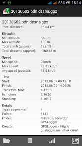
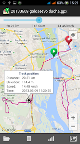
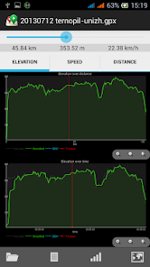
Trackalizer is intended to analise recorded GPS tracks. It calculates statistics, builds various profile graphs and shows track on a map. Also you can inspect any track point on graph or on map.
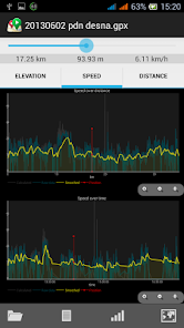
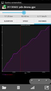
Available graphs and profiles:
• Elevation over distance
• Elevation over time
• Speed over distance
• Speed over time
• Distance over time
Elevation and speed data is smoothed to show nice graph and provide more accurate statistics.
If your track does not contain elevation or it is inaccurate you can download DEM data from MapQuest. It's useful when you have a route track and want to estimate climb and descent.
File formats supported:
• GPX - GPS eXchange Format
• PLT - OziExplorer Track Point
• KML - Keyhole Markup Language
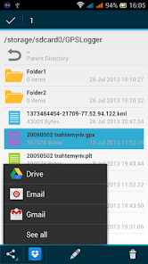
On Android 4.0 and above you can share your track files to Dropbox, Google Drive, Email, etc. Rename and delete files.
App is in BETA state. Please send me your tracks if you have problems with them.
It was tested on android 4.x devices. Nevertheless it can work on 2.x devices as well but with minor UI differences.
Available graphs and profiles:
• Elevation over distance
• Elevation over time
• Speed over distance
• Speed over time
• Distance over time
Elevation and speed data is smoothed to show nice graph and provide more accurate statistics.
If your track does not contain elevation or it is inaccurate you can download DEM data from MapQuest. It's useful when you have a route track and want to estimate climb and descent.
File formats supported:
• GPX - GPS eXchange Format
• PLT - OziExplorer Track Point
• KML - Keyhole Markup Language
On Android 4.0 and above you can share your track files to Dropbox, Google Drive, Email, etc. Rename and delete files.
App is in BETA state. Please send me your tracks if you have problems with them.
It was tested on android 4.x devices. Nevertheless it can work on 2.x devices as well but with minor UI differences.
Updated on
Data safety
Developers can show information here about how their app collects and uses your data. Learn more about data safety

No information available
Ratings and reviews
4.7
38 reviews

A Google user
- Flag inappropriate
- Show review history
August 9, 2018
Swift UI, efficient. Downside: Graphs use fixed resolution - text too small
on hd displays.
A Google user
- Flag inappropriate
February 20, 2018
Just crashed at loading
A Google user
- Flag inappropriate
December 25, 2013
Very good. The only remarks: if the slider for point by point following of track would be at the bottom of the screen, it'd be more natural to use. Also, it's difficult to make the slider stop exactly at a desired point, like the one of max speed, for instance. It'd be nice if one could tap to move the slider point by point, for fine tuning. It'd also be good to be able to see and follow data without any smoothing at all, as well as total ascend and descent distances. :-)
Abogado de Avocado
July 17, 2014
Added arrows near the slider in new version. Please update.
What's new
- Fixed KML parsing with multiple track segments
- Minimum API level 8 (Froyo 2.2)
- Seekbar moved to the bottom of the screen on charts and map screens
- Fixed PLT parsing without time
- DEM data downloading can be cancelled with back button
- Added "Prev" and "Next" buttons in seekbar to move point by point on the track
- Added Royal units system (miles, ft, mph), check preferences to switch Metric/Royal systems
- Fixed GPX parsing with time containing timezome


