
BusBahnBim
4.9star
4.02K reviews
100K+
Downloads

Everyone
info


About this app
With the BusBahnBim App you will always find the best route in all of Austria: whether by public transport, on foot, by bike or by car. Based on the Traffic Information Austria (VAO), the multimodal app is working multimodally – you can also combine with functions like Bike & Ride, Park & Ride and Car Train.
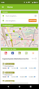
BusBahnBim works simply by address input and always uses the most up-to-date data. For example, the current traffic situation can also be included, including construction sites, congestion, delays, diversions, etc. Also stop-call names are no longer necessary for the query, by activating the GPS-positioning, the current location can be used as the starting point. Optionally, the desired destination address, a street name or point of interest can be used.
The BusBahnBim App allows quick, uncomplicated information, a realistic comparison of the time involvement of different modalities, clear maps and charts to the orientation offer and fascinate with a modern design. A favorite choice, dispatch of the connection and info via e-mail or SMS, storage of the departure times and arrival times in the calendar are other useful features.
Overview of the functions of the BusBahnBim App:
· Stop search via GPS
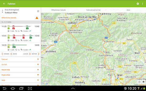
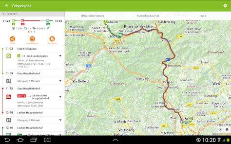
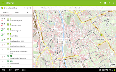
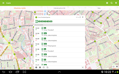
· Journey proposals incl. time involvement
· Connecting dispatch via e-mail or SMS
· Memory possibility with reminiscent function in the calendar
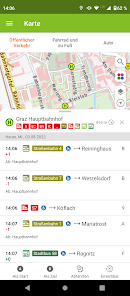
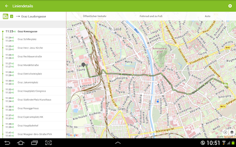
· Clear map representation by high-resolution map
· Define your own favorites
· Intermodal comparison between public transportation, foot / bicycle routes and motocar routes and the time involvement
· Monitor announcement for an elective stop
Description of permissions:
· Camera:
Allows the user to take a photo for a personal take-me-there favorite in the trip planner.
· Contacts:
Enables that the usage of contacts/addresses from the users phone book for searching (e.g. input of start or destination in the trip planner or searching via map view).
· Location:
Network-based locating or locating via GPS enables routing to or from the current position.
· Have full network access:
Is necessary for internet access of the app.
· Install shortcuts:
Enables the user so save shortcuts on the home screen of the device.
· View network connections:
Allows the app to check the status of the internet connection (access yes/no, type of connection (wifi, mobile data etc.)).
BusBahnBim works simply by address input and always uses the most up-to-date data. For example, the current traffic situation can also be included, including construction sites, congestion, delays, diversions, etc. Also stop-call names are no longer necessary for the query, by activating the GPS-positioning, the current location can be used as the starting point. Optionally, the desired destination address, a street name or point of interest can be used.
The BusBahnBim App allows quick, uncomplicated information, a realistic comparison of the time involvement of different modalities, clear maps and charts to the orientation offer and fascinate with a modern design. A favorite choice, dispatch of the connection and info via e-mail or SMS, storage of the departure times and arrival times in the calendar are other useful features.
Overview of the functions of the BusBahnBim App:
· Stop search via GPS
· Journey proposals incl. time involvement
· Connecting dispatch via e-mail or SMS
· Memory possibility with reminiscent function in the calendar
· Clear map representation by high-resolution map
· Define your own favorites
· Intermodal comparison between public transportation, foot / bicycle routes and motocar routes and the time involvement
· Monitor announcement for an elective stop
Description of permissions:
· Camera:
Allows the user to take a photo for a personal take-me-there favorite in the trip planner.
· Contacts:
Enables that the usage of contacts/addresses from the users phone book for searching (e.g. input of start or destination in the trip planner or searching via map view).
· Location:
Network-based locating or locating via GPS enables routing to or from the current position.
· Have full network access:
Is necessary for internet access of the app.
· Install shortcuts:
Enables the user so save shortcuts on the home screen of the device.
· View network connections:
Allows the app to check the status of the internet connection (access yes/no, type of connection (wifi, mobile data etc.)).
Updated on
Safety starts with understanding how developers collect and share your data. Data privacy and security practices may vary based on your use, region, and age. The developer provided this information and may update it over time.

No data shared with third parties
Learn more about how developers declare sharing

No data collected
Learn more about how developers declare collection
Ratings and reviews
4.9
3.96K reviews

Denys Moroz
- Flag inappropriate
April 15, 2024
Perfect app. But please, add dark theme.
Verkehrsauskunft Österreich
April 15, 2024
Danke für Ihr positives Feedback. Wir werden den "Dark mode" mit unserem Entwickler besprechen.

Maximilian Pleyer
- Flag inappropriate
- Show review history
October 27, 2021
Wie angefragt betrifft das die Linien 3 und 5 Abfahrtszeiten Tabellen in der Station stimmen nicht mit den Zeiten der App überein. In der Zwischenzeit probieren ich mal Graz Mobile App aus ~ ich hoffe die sind besser. Departure times for Tram line 3 & 5 posted at the stations/stop do not match the ones stated in your App. But of course the follow the posted schedules, hence often miss the train. Hope you can fix it soon. In the meantime I switch to Graz Mobile ~ hope that they are more accurate.
1 person found this review helpful
Verkehrsauskunft Österreich
October 28, 2021
Für detaillierte Bearbeitung wäre wirklich die Kommunikation per Mail besser: feedback@verbundlinie.at - an welcher Haltestelle genau? welche Uhrzeit, welcher Tag? wie fragen Sie mit der App ab? (Route oder Abfahrtsmonitor) ...

A Google user
- Flag inappropriate
January 18, 2020
I use it almost every day and it is always correct. In order to reach a train one should be careful to add at least 10 minutes to what the app suggests. In other words: take the earlier bis or tram connection. The response to one complaint was very polite and helpful.
5 people found this review helpful
What's new
Update fixes an error when selecting February 29, 2024.


