MapEver photo map
4.7star
6 reviews
500+
Downloads

Everyone
info

About this app
This is a early preview release. It works well for me and thus I am making it available for everyone, but please consider it "work in progress".
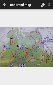
MapEver allows you to easily navigate in small areas (e.g. zoos or parks) where specific online maps are not available. Using only the phone's GPS, you can navigate on a photographed map of your location to get around smoothly.
- Take a photo of the map (optionally crop it)
- As you walk around, place markers corresponding to your current position on the photo
- Once you have placed at least 2 markers, the app can track where you currently are
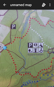
Precision increases with more markers placed, 3 is usually the minimum for good results.
You can place markers more quickly by selecting distinct points in some other map application (osmand is very good), share that location (via "geo:" URL/intent) and select the corresponding point on the photographed map - road crossings are often ideal for this.
Shared geo coordinates will also be shown on the map photo as if you were at that location if you already have enough markers.
Via long-press you can also share the (estimated) GPS coordinates of a point on the photo.
Source code available at https://github.com/rdoeffinger/MapEver/tree/tmp
MapEver allows you to easily navigate in small areas (e.g. zoos or parks) where specific online maps are not available. Using only the phone's GPS, you can navigate on a photographed map of your location to get around smoothly.
- Take a photo of the map (optionally crop it)
- As you walk around, place markers corresponding to your current position on the photo
- Once you have placed at least 2 markers, the app can track where you currently are
Precision increases with more markers placed, 3 is usually the minimum for good results.
You can place markers more quickly by selecting distinct points in some other map application (osmand is very good), share that location (via "geo:" URL/intent) and select the corresponding point on the photographed map - road crossings are often ideal for this.
Shared geo coordinates will also be shown on the map photo as if you were at that location if you already have enough markers.
Via long-press you can also share the (estimated) GPS coordinates of a point on the photo.
Source code available at https://github.com/rdoeffinger/MapEver/tree/tmp
Updated on
Safety starts with understanding how developers collect and share your data. Data privacy and security practices may vary based on your use, region, and age. The developer provided this information and may update it over time.

No data shared with third parties
Learn more about how developers declare sharing

No data collected
Learn more about how developers declare collection
Ratings and reviews
4.7
6 reviews
What's new
Compatibility with Android 14