
Copernicus Sentinel
3.9star
380 reviews
50K+
Downloads

Everyone
info


About this app
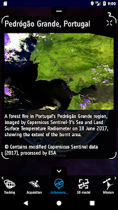
The Sentinel App is a gateway to knowing the Copernicus Sentinel satellites. It lets users track the satellites in real-time, discover their key elements, read the latest news and learn more about their products.
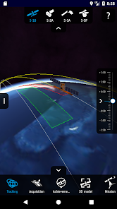
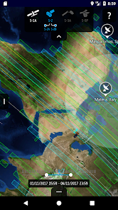
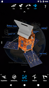
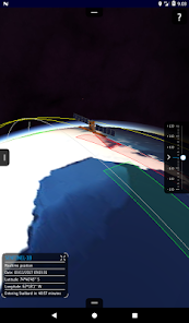
Users can, among other things, explore detailed 3D models of the satellites, see the last and next time they have been and will be over the user's location, move the satellites to the time of the last data transmission and smoothly move them back to their current location over the 3D globe. Notifications can also be set to be warned when the satellites are flying by.
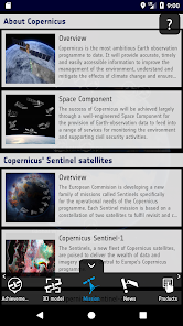
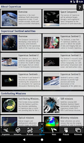
ESA is developing a series of next-generation Earth observation missions, on behalf of the joint ESA/European Commission initiative Copernicus (previously GMES - Global Monitoring for Environment and Security).
The goal of the program is to replace current and older Earth observation missions, such as ERS and Envisat, which have reached or are close to reaching the end of their operational life span. This will ensure a continuity of data so that there are no gaps in ongoing studies.
Each mission will focus on a different aspect of Earth observation, such as Atmospheric, Oceanic or Land monitoring, and the data will be of use in many applications.
Users can, among other things, explore detailed 3D models of the satellites, see the last and next time they have been and will be over the user's location, move the satellites to the time of the last data transmission and smoothly move them back to their current location over the 3D globe. Notifications can also be set to be warned when the satellites are flying by.
ESA is developing a series of next-generation Earth observation missions, on behalf of the joint ESA/European Commission initiative Copernicus (previously GMES - Global Monitoring for Environment and Security).
The goal of the program is to replace current and older Earth observation missions, such as ERS and Envisat, which have reached or are close to reaching the end of their operational life span. This will ensure a continuity of data so that there are no gaps in ongoing studies.
Each mission will focus on a different aspect of Earth observation, such as Atmospheric, Oceanic or Land monitoring, and the data will be of use in many applications.
Updated on
Safety starts with understanding how developers collect and share your data. Data privacy and security practices may vary based on your use, region, and age. The developer provided this information and may update it over time.

No data shared with third parties
Learn more about how developers declare sharing

This app may collect these data types
Device or other IDs

Data is encrypted in transit

You can request that data be deleted
Ratings and reviews
3.8
346 reviews

S “Irish” O'D
- Flag inappropriate
- Show review history
February 26, 2021
I was looking online to find out Sentinel 2 orbit paths for a project I'm planning over the summer, and this app is even better than I could expect! I'll use this in conjunction with the kml aqcuisition files to better plan and visualise when a Sentinel goes over. Maybe I'll give it a wave! It would be nice if you could select a location and it would tell you when it is next arriving/last arrived, in lieu of a notification of when it's overhead currently. Otherwise, Thank you ESA!
9 people found this review helpful

A Google user
- Flag inappropriate
April 19, 2020
Fine app, but it has one big flaw, zoom is not good enough. You can recognize really big objects, like bridges and larger. If you want to see some building activities, like I have intended, that kind of stuff is not recognizable.
11 people found this review helpful

Dom Dbcq
- Flag inappropriate
September 24, 2020
Impressive piece of software;should be more promoted on the era website; found by accident by one of my colleagues.Great
1 person found this review helpful
What's new
- Fix news feeds for Sentinel-1,2,3 and 5P
- Fix issue occasionally preventing users from accessing the products catalogue
- Fix access to PDF version of the achievements
- Fix issue occasionally preventing users from accessing the products catalogue
- Fix access to PDF version of the achievements


