

SDVFR

50K+
Downloads

Everyone
info


About this app
This application is intended for pilots of light airplanes, microlights and users of computer simulators. It covers mainland France and partially overseas.
Feature lists:
- GPS tracking of the device: Position, ground speed, heading, altitude
- Vector speed with bubbles or dashes of time
- Management of the current navigation point (heading to be taken / time remaining)
- Choice of display of wind & drift, height, or arrival time at destination
- Intelligent self-centering of the map
- North-true modes or direction of the device
- Quick "Direct" function
- The "Direct" function allows you to search for towns, villages (if connected)
- Automatic recording of your flight tracks (visualization directly in SDVFR or export to KML or GPX formats)
- Easily embed all SIA documentation (VAC, VAC HELI, AIP, SUP AIP, AZBA)
- Easy access to VFR & weather guides, supplement to maps, legends
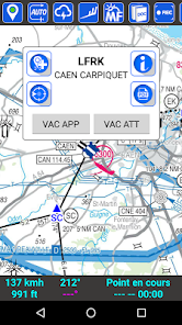
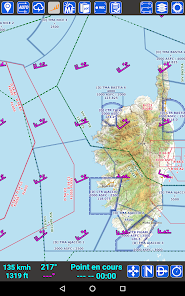
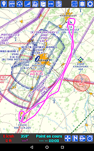
- Geo-referenced VAC placed on the base map (approach, turn of the track, taxiways & car parks)
- Geo-referenced AIP SUP (see areas from AIP SUPs directly on the map)
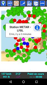
- Weather messages: METAR, TAF, SIGMET (decoding, colors, wind alert, graphic sigmets)
- Widget "My station" to quickly view your favorite METAR & TAF without launching the application
- Position and information of airports / aerodromes / heliports / ULM bases (http://basulm.ffplum.info)
- View wintems on 18 different levels (FL005 to FL150) over 24 hour forecasts
- Direct access to Météo-France maps (Wintem & Temsi)
- Aeronautical cards: IGN 500K, SIA 250K, CartaBossy, Editerra Air Million (paying)
- SDOACI France & Corsica aeronautical map (free)
- SIA million maps & cruises, OpenStreetMap, IGN Road scan 1M / 250K road (free)
- Display multiple cards in the order you want
- Paid option to use your own cards (mbtiles format)
- Automatic synchronization of planes, navigations and maps between your terminals
- On-demand synchronization of your flight tracks
- Notams of aerodromes and FIR
- Dynamic AZBA function
- VFR reporting points
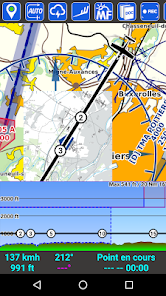
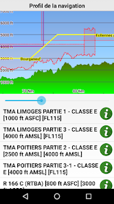
- Dynamic profile (sectional view of the air spaces in front of you)
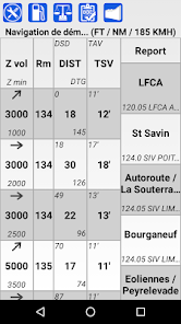
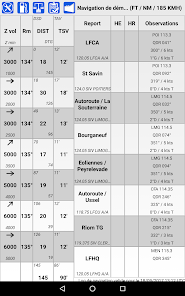
- Easily build a navigation and see the corresponding nav log
- Associate frequencies on its navigation log
- Automatic calculation of drift and effective wind, weather with wind
- Theoretical calculation of ascents / descents
- Manage a list of devices with their characteristics
- "Flight file" screen: Land, Notams, METAR, TAF on your route
- Complete navigation profile (relief & airspaces crossed)
- View an airspace and its information easily via a double-tap on the map
- Manage your browsing (PDF export, save, print, send by email)
- Import / Export of navigations or tracks in GPX format
- Export of navigations in PLN format for FSX or P3D
- Export of navigations in FPL format for Garmin
- Edit fuel quotes (PDF export, printing, sending by email)
- Screen of masses and centering
- Modifiable units (altitude, distance, speed)
- Customization of line thicknesses and colors (navigation, speed vector, track)
- VOR / NDB overlaps
- Management of personalized points (UserWaypoints)
- Display KML files on the map
- Two stopwatches
- Magnetic variation taken into account
- Application designed for non-connected use
- Uses official data from the AIS
- Automatic update (AIRAC cycle every 28 days)
- Connection to a simulator (FS2020, FSX, P3D, X-Plane, FlightGear, AeroFly)
- Connection to a traffic detection unit (GDL90 or Flarm NMEA via Wifi)
- System of "notams" to be informed on the state of health of the application
- Store personal PDF files in Document Explorer
- GUND correction to refine the altitude provided by the GPS
Feature lists:
- GPS tracking of the device: Position, ground speed, heading, altitude
- Vector speed with bubbles or dashes of time
- Management of the current navigation point (heading to be taken / time remaining)
- Choice of display of wind & drift, height, or arrival time at destination
- Intelligent self-centering of the map
- North-true modes or direction of the device
- Quick "Direct" function
- The "Direct" function allows you to search for towns, villages (if connected)
- Automatic recording of your flight tracks (visualization directly in SDVFR or export to KML or GPX formats)
- Easily embed all SIA documentation (VAC, VAC HELI, AIP, SUP AIP, AZBA)
- Easy access to VFR & weather guides, supplement to maps, legends
- Geo-referenced VAC placed on the base map (approach, turn of the track, taxiways & car parks)
- Geo-referenced AIP SUP (see areas from AIP SUPs directly on the map)
- Weather messages: METAR, TAF, SIGMET (decoding, colors, wind alert, graphic sigmets)
- Widget "My station" to quickly view your favorite METAR & TAF without launching the application
- Position and information of airports / aerodromes / heliports / ULM bases (http://basulm.ffplum.info)
- View wintems on 18 different levels (FL005 to FL150) over 24 hour forecasts
- Direct access to Météo-France maps (Wintem & Temsi)
- Aeronautical cards: IGN 500K, SIA 250K, CartaBossy, Editerra Air Million (paying)
- SDOACI France & Corsica aeronautical map (free)
- SIA million maps & cruises, OpenStreetMap, IGN Road scan 1M / 250K road (free)
- Display multiple cards in the order you want
- Paid option to use your own cards (mbtiles format)
- Automatic synchronization of planes, navigations and maps between your terminals
- On-demand synchronization of your flight tracks
- Notams of aerodromes and FIR
- Dynamic AZBA function
- VFR reporting points
- Dynamic profile (sectional view of the air spaces in front of you)
- Easily build a navigation and see the corresponding nav log
- Associate frequencies on its navigation log
- Automatic calculation of drift and effective wind, weather with wind
- Theoretical calculation of ascents / descents
- Manage a list of devices with their characteristics
- "Flight file" screen: Land, Notams, METAR, TAF on your route
- Complete navigation profile (relief & airspaces crossed)
- View an airspace and its information easily via a double-tap on the map
- Manage your browsing (PDF export, save, print, send by email)
- Import / Export of navigations or tracks in GPX format
- Export of navigations in PLN format for FSX or P3D
- Export of navigations in FPL format for Garmin
- Edit fuel quotes (PDF export, printing, sending by email)
- Screen of masses and centering
- Modifiable units (altitude, distance, speed)
- Customization of line thicknesses and colors (navigation, speed vector, track)
- VOR / NDB overlaps
- Management of personalized points (UserWaypoints)
- Display KML files on the map
- Two stopwatches
- Magnetic variation taken into account
- Application designed for non-connected use
- Uses official data from the AIS
- Automatic update (AIRAC cycle every 28 days)
- Connection to a simulator (FS2020, FSX, P3D, X-Plane, FlightGear, AeroFly)
- Connection to a traffic detection unit (GDL90 or Flarm NMEA via Wifi)
- System of "notams" to be informed on the state of health of the application
- Store personal PDF files in Document Explorer
- GUND correction to refine the altitude provided by the GPS
Updated on
Safety starts with understanding how developers collect and share your data. Data privacy and security practices may vary based on your use, region, and age. The developer provided this information and may update it over time.

No data shared with third parties
Learn more about how developers declare sharing

No data collected
Learn more about how developers declare collection
What's new
Lire le magasin de certificats de l'utilisateur en particulier pour Android 7.0 de manière à permettre à l'application de continuer à fonctionner sur cette version d'Android
Compilation Android SDK 33
Corrections suite à la montée de version
Compilation Android SDK 33
Corrections suite à la montée de version