Archeotracker
5K+
Downloads

Everyone
info

About this app
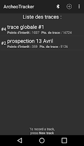
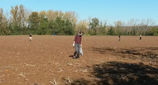
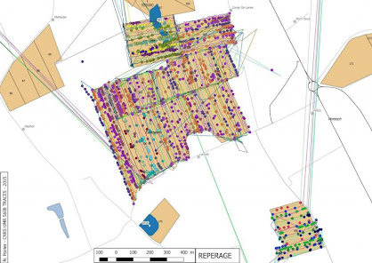
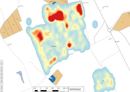
Archeotracker is an app for the global geolocation of data and artefacts produced in archaeological surveys. The app allows to record continuously by discriminating the main categories of objects identified during the survey. In a survey team, each participant must have an Android smartphone with Archeotracker in an arm phone sport pocket. The prospector can, thus, without any loss of time, record the precise position of the objects in the studied areas. It is also possible to record the course of the prospectors and therefore to measure the gap to the theoretical grid of survey for each member of the team. After having completed the surveys, it is easy to export .gpx files and restore GIS density maps, and the exact itinerary of prospectors, whatever their number. It is then possible to process these data in terms of spatial analysis, for example with heat maps. To conclude with, this app makes possible to systematize and homogenize the recording of the data on site, but also off-site.
Since version 2.0, several improvements have been made:
-there is a bluetooth option that allows merging the records of each prospector on the same phone at the end of each local area. The team leader can therefore at any time gather and view the data on his own cell phone. That is only possible if all the devices have been paired beforehand with the team leader’s one. Once this merge is completed, the data export to the computer is simplified and can only be done from the team leader's phone. In the global .gpx file, each point remains traceable by the bluetooth short name of each cell phone.
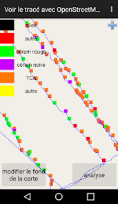
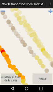
-a simplified tool of heat map, integrated with the application, makes possible to identify a concentration of artefacts "in situ". When data appears on the map, an "analysis" button allows to categorize the points according to their proximity to the other points. Several settings are available to refine the result, depending on the grid pitch.
- it is now possible to modify the background of the map. By default, only Open Street Map (OSM) was available (with an internet connection). A new option allows to add offline map backgrounds. This involves creating a .mbtile file from a computer and then integrating it into the phone. This option makes possible to display old maps, cadastral extracts, or previous survey data, and to have this data available at all times.
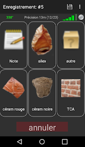
- the adaptation of the buttons for each type of survey is now available. Indeed, an interface allows to modify the number of buttons on the screen, the picture and the title of the buttons. Several types of buttons are available (tag to save an object, note to write a short text, picture or voice recording). All these data are georeferencable. It is also possible to register several button configurations for each type of survey. These configurations are themselves exportable on all the other cell phones of the team through bluetooth.
- several operating instructions have been integrated into the application in order to make its use easier.
The app was developed by Emile Hautefeuille, on an idea of Florent Hautefeuille, associate professor in medieval archeology at the University of Toulouse. It has been tested on several surveying areas of the laboratory 5608 TRACES, especially on the program REPERAGE, directed by Nicolas Poirier. Participants in the program were Anna Luiza Rezende Ladeia (Master), Lydia Allué Andrès (Master), Noemie Luaut (PhD) and Clement Vinco (PhD).
The application uses : https://github.com/labexp/osmtracker-android (N. Guillaumin).
Since version 2.0, several improvements have been made:
-there is a bluetooth option that allows merging the records of each prospector on the same phone at the end of each local area. The team leader can therefore at any time gather and view the data on his own cell phone. That is only possible if all the devices have been paired beforehand with the team leader’s one. Once this merge is completed, the data export to the computer is simplified and can only be done from the team leader's phone. In the global .gpx file, each point remains traceable by the bluetooth short name of each cell phone.
-a simplified tool of heat map, integrated with the application, makes possible to identify a concentration of artefacts "in situ". When data appears on the map, an "analysis" button allows to categorize the points according to their proximity to the other points. Several settings are available to refine the result, depending on the grid pitch.
- it is now possible to modify the background of the map. By default, only Open Street Map (OSM) was available (with an internet connection). A new option allows to add offline map backgrounds. This involves creating a .mbtile file from a computer and then integrating it into the phone. This option makes possible to display old maps, cadastral extracts, or previous survey data, and to have this data available at all times.
- the adaptation of the buttons for each type of survey is now available. Indeed, an interface allows to modify the number of buttons on the screen, the picture and the title of the buttons. Several types of buttons are available (tag to save an object, note to write a short text, picture or voice recording). All these data are georeferencable. It is also possible to register several button configurations for each type of survey. These configurations are themselves exportable on all the other cell phones of the team through bluetooth.
- several operating instructions have been integrated into the application in order to make its use easier.
The app was developed by Emile Hautefeuille, on an idea of Florent Hautefeuille, associate professor in medieval archeology at the University of Toulouse. It has been tested on several surveying areas of the laboratory 5608 TRACES, especially on the program REPERAGE, directed by Nicolas Poirier. Participants in the program were Anna Luiza Rezende Ladeia (Master), Lydia Allué Andrès (Master), Noemie Luaut (PhD) and Clement Vinco (PhD).
The application uses : https://github.com/labexp/osmtracker-android (N. Guillaumin).
Updated on
Data safety
Developers can show information here about how their app collects and uses your data. Learn more about data safety

No information available
What's new
Bugs fixed. Optimization of tracks exchange through bluetooth and analysis tools (heat map). Full customization of track buttons. Possibility to add several configurations of buttons, and to exchange these configurations through bluetooth. Possibility to add offline map backgrounds with mbtiles files.