
iFly EFB
In-app purchases
4.6star
467 reviews
50K+
Downloads

Everyone
info


About this app
iFly GPS has been renamed to iFly EFB!
The Better Way to Navigate:
iFly EFB delivers the perfect combination of value, capability, and usability for both VFR and IFR Pilots. Safely and quickly get the information you need so you can focus on flying!
Designed by Pilots, Tested by Pilots and Recommended by Pilots:
iFly GPS for Android was built on the knowledge and experience from our line of aviation portables, and a collaborative user experience based on feedback from thousands of fellow pilots.
Free 30-Day Trial:
Enjoy a free 30-day IFR/VFR subscription, and see how iFly EFB provides you with what you need for aviation.
Requires: Android 4.0.x or higher, plus 500 MB data storage.
Affordability for All:
Enjoy comprehensive and simple updates with affordable subscriptions for only $79.99 VFR or $129.99 IFR/VFR per year. Existing iFly aviation portable or iOS subscribers can extend their subscription to their Android for only $24.99.
Feature Highlights:
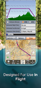
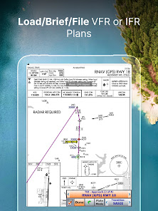
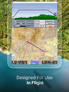
Flight Planning with an intuitive interface allowing for simple building of direct-to or multiple waypoint flight plans directly on the FAA, Vector charts or the Flight Plan page. Set a departure and destination, and then customize your path with the rubber-band feature.
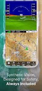
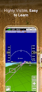
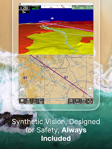
Synthetic Vision with 3D traffic brings your situational awareness to an all time high! Works on both phone and tablet platforms!
Active Alerting System from Airspace Alerts to Collision Alerts, our Active Alerting System provides a central location for Alerts and more.
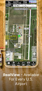
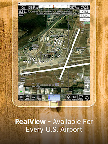
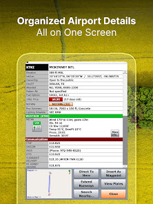
RealView Airports provides satellite imaging of 12,600+ Airports for pilot reference and our AutoTaxi+ feature. Have a visual knowledge of the airport before arrival.
AutoTaxi+ transitions to the Airport Diagram upon landing or from Taxi Diagram to Chart Mode upon Take-off. You Android will use the RealView image as a taxi-diagram if an official FAA Diagram is nor present. See your position on over 12,600 airports!
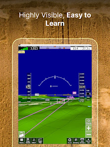
Instruments Page simulates real aircraft instruments, gathering information from GPS (or an attached 3rd party AHRS) to create familiar images. Reference instruments such as HSI, VSI, Groundspeed, Altimeter, Turn Indicator, etc. Add an AHRS and get an Artificial Horizon with Attitude Safety Alerts.
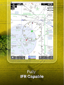
VFR / IFR Data is included, complete with US geo-referenced Sectionals, TACs, Low-Enroute, Approach Plates, Airport Diagrams and much more. Everything from flight planning to flying is designed around image-enhanced charts from the FAA.
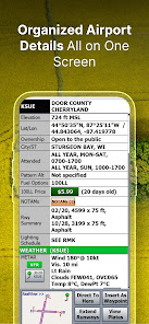
Geo-Reference Approach Plates and Airport Diagrams provide pilots with actual FAA Approached and Airport Diagrams beautifully represented.
Public / Private Airports using official databases for both Public and Private airport information. Databases update directly from the FAA Data Cycles. Create your own Custom Waypoints for those locations that are not on the charts or maps.
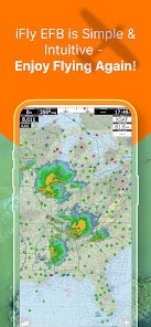
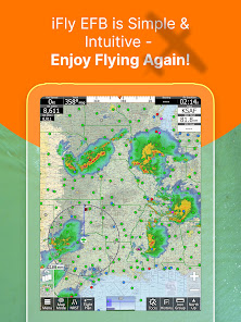
Pre-Flight Weather provides an interactive map with graphical VFR/IFR visuals and allows for touch reporting of METARS, TAFs and Winds Aloft at your fingertips.
ADS-B Weather / Traffic - iFly EFB for Android supports connection to third party ADS-B devices including iLevil, NavWorx, Dual, SkyGuardTWX, Clarity, or SkyRadar and more for free Weather and Traffic.
KEY FEATURES:
-Moving Map Modes
• VFR (Sectionals, WAC, TAC)
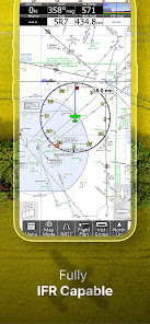
• Low/High-Enroute Charts
• Vector Base Map
• Geo-Referenced Plates & Diagrams (Approach, Departure, Stars)
-Dynamic Map Overlays
• Synthetic Vision with 3D Traffic
• Weather and Nexrad (Pre-Flight or ADS-B Live)
• Terrain and Obstructions
• Fuel Prices
• Approach Plates
-Instruments Panel
-Day/Night Mode
-Instrument Layouts (with over 24 Instruments including HSI, Vertical Profile, and AHRS)
-Fly Direct-To
-Vertical terrain planning and Airspace preview
-Save/Load Flight Plans and Waypoints
-Find Nearest
-History
-North Up / Track Up
-Pinch Zooming w/ One Touch Feature
-Map Settings
-Alerts & Warnings
-Button Fading
-Custom Waypoints
-Customizable Instruments
-Simulator Mode
The Better Way to Navigate:
iFly EFB delivers the perfect combination of value, capability, and usability for both VFR and IFR Pilots. Safely and quickly get the information you need so you can focus on flying!
Designed by Pilots, Tested by Pilots and Recommended by Pilots:
iFly GPS for Android was built on the knowledge and experience from our line of aviation portables, and a collaborative user experience based on feedback from thousands of fellow pilots.
Free 30-Day Trial:
Enjoy a free 30-day IFR/VFR subscription, and see how iFly EFB provides you with what you need for aviation.
Requires: Android 4.0.x or higher, plus 500 MB data storage.
Affordability for All:
Enjoy comprehensive and simple updates with affordable subscriptions for only $79.99 VFR or $129.99 IFR/VFR per year. Existing iFly aviation portable or iOS subscribers can extend their subscription to their Android for only $24.99.
Feature Highlights:
Flight Planning with an intuitive interface allowing for simple building of direct-to or multiple waypoint flight plans directly on the FAA, Vector charts or the Flight Plan page. Set a departure and destination, and then customize your path with the rubber-band feature.
Synthetic Vision with 3D traffic brings your situational awareness to an all time high! Works on both phone and tablet platforms!
Active Alerting System from Airspace Alerts to Collision Alerts, our Active Alerting System provides a central location for Alerts and more.
RealView Airports provides satellite imaging of 12,600+ Airports for pilot reference and our AutoTaxi+ feature. Have a visual knowledge of the airport before arrival.
AutoTaxi+ transitions to the Airport Diagram upon landing or from Taxi Diagram to Chart Mode upon Take-off. You Android will use the RealView image as a taxi-diagram if an official FAA Diagram is nor present. See your position on over 12,600 airports!
Instruments Page simulates real aircraft instruments, gathering information from GPS (or an attached 3rd party AHRS) to create familiar images. Reference instruments such as HSI, VSI, Groundspeed, Altimeter, Turn Indicator, etc. Add an AHRS and get an Artificial Horizon with Attitude Safety Alerts.
VFR / IFR Data is included, complete with US geo-referenced Sectionals, TACs, Low-Enroute, Approach Plates, Airport Diagrams and much more. Everything from flight planning to flying is designed around image-enhanced charts from the FAA.
Geo-Reference Approach Plates and Airport Diagrams provide pilots with actual FAA Approached and Airport Diagrams beautifully represented.
Public / Private Airports using official databases for both Public and Private airport information. Databases update directly from the FAA Data Cycles. Create your own Custom Waypoints for those locations that are not on the charts or maps.
Pre-Flight Weather provides an interactive map with graphical VFR/IFR visuals and allows for touch reporting of METARS, TAFs and Winds Aloft at your fingertips.
ADS-B Weather / Traffic - iFly EFB for Android supports connection to third party ADS-B devices including iLevil, NavWorx, Dual, SkyGuardTWX, Clarity, or SkyRadar and more for free Weather and Traffic.
KEY FEATURES:
-Moving Map Modes
• VFR (Sectionals, WAC, TAC)
• Low/High-Enroute Charts
• Vector Base Map
• Geo-Referenced Plates & Diagrams (Approach, Departure, Stars)
-Dynamic Map Overlays
• Synthetic Vision with 3D Traffic
• Weather and Nexrad (Pre-Flight or ADS-B Live)
• Terrain and Obstructions
• Fuel Prices
• Approach Plates
-Instruments Panel
-Day/Night Mode
-Instrument Layouts (with over 24 Instruments including HSI, Vertical Profile, and AHRS)
-Fly Direct-To
-Vertical terrain planning and Airspace preview
-Save/Load Flight Plans and Waypoints
-Find Nearest
-History
-North Up / Track Up
-Pinch Zooming w/ One Touch Feature
-Map Settings
-Alerts & Warnings
-Button Fading
-Custom Waypoints
-Customizable Instruments
-Simulator Mode
Updated on
Safety starts with understanding how developers collect and share your data. Data privacy and security practices may vary based on your use, region, and age. The developer provided this information and may update it over time.


Ratings and reviews
4.4
310 reviews

Kevin Chaffee
- Flag inappropriate
January 18, 2022
I love this app and have used it exclusively for several years after trying Garmin Pilot. It is very stable, easy to use, intuitive, and the folks at Adventure Pilot are super nice and always ready to help if needed. I have this app on my Galaxy tablet, cell phone, and laptop and it works great on all of them. I have a Stratux ADS-B receiver in my Cardinal and the traffic and weather are a lifesaver. I'd highly recommend this app and company to pilots if they want a simpler, yet powerful copilot.
8 people found this review helpful
Adventure Pilot, LLC
January 18, 2022
Thanks Kevin!

Robert Lesnick
- Flag inappropriate
March 4, 2022
Been using VFR for a few years on my Android phone. App has always been stable with no inflight issues. Have used on several coast to coast flights with multiple legs. Easy to use with most features intuitive. Learning curve is short. Doesn't significantly add to pilot inflight workload. Only real negative for me is its airport taxi view capability which is aerial photo based and which is not particularly useful. App is compatible with a Dynon DRX portable ADS-B receiver. Good simple app.
7 people found this review helpful
Adventure Pilot, LLC
March 4, 2022
Thanks Robert for the great review! By the way, we show georeferenced airport diagrams as well...but of course not every airport has a published diagram. Give us a call if you need any help with that feature 214-585-0444.

Philip Rash
- Flag inappropriate
February 24, 2022
Though it seems most other pilots I know use the other "big" app (that starts with an "F"), I never jumped on that bandwagon, partly because I'm not interested in buying an ipad just to run it. One of the best features of iFly GPS that lured me in is how it works on multiple device types, including Android. I can run it on both my Android phone and Android tablet at no extra cost, and it has all the features I desire most: georeferenced charts (vfr and ifr), ADS-B datalink, and overall ease of use. I've been using this app for several years and hope it keeps staying awesome!
16 people found this review helpful
Adventure Pilot, LLC
February 24, 2022
Thanks Philip! I have no problem with using the "F" word here - there is plenty of room for more than one good app in this market ;-). Super glad you chose iFly!
What's new
1. All new Map graphics engine to enable faster rendering, with higher fidelity graphics in the near future.
2. Map Rendering frame and fill rates are notably faster than in previous versions.
3. All new Vector Mode Hi-Res VFR-Colored Terrain and Elevation Highlights.
4. Added Flight Plan Export option for ForeFlight.
5. Improved/Fixed support for Gyroplanes & Icon.
6. Improved Avidyne user experience.
7. Enabled Weather Updates while downloading Map Data.
8. Numerous bug fixes and improvements.