
鷹乃目 - 位置情報と状況をGoogleMapにマーカーで表
Contains ads
50+
Downloads

Everyone
info
About this app
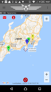
Takanome is an application that displays the location and status on GoogleMap with a marker with a message and can be shared with other users.
Users can grasp each other's current location and share the surrounding weather and road conditions.
Markers can be made public or private when they are created. It is safe even for private exchanges.
Markers can be placed on the map, which can be used to confirm safety in the event of a disaster or accident.
- - 【Overview】 - - - - - - - - - - - - - - - - - - - - - - - - - - - - - - - - - - - - - - - - - - - - - --------------------------
Takanome is an application that works by providing information to each user.
Information from nearby users may be helpful, and your information may help other users.
For example,
・ If you indicate where to meet on the map, you won't have to get lost in the city you visited for the first time, and you can find friends in the crowd.
-If you indicate the location where traffic jams are occurring, nearby users can avoid traffic jams.
・ If you start Takanome at a solo touring destination that you went out to, you may have friends nearby.
・ It may be used for announcement of where the event starts.
・ If you have a disaster, you can inform your family of your safety with detailed location. (If the communication infrastructure is operating stably after the disaster, but ...)
Why don't you join Takanome user?
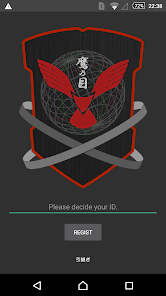
You can use it just by installing it on your smartphone and deciding your favorite ID.
--[Main functions]------------------------------------- ---------------------------
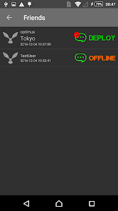
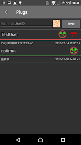
[Plug connection]
Takanome users can be "plugged".
"Plug connection" is a relationship equivalent to "Friends" or "Friends" of other services.
Only users who have plugged in can share location information and use the chat function.
* * * * *
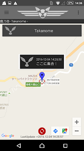
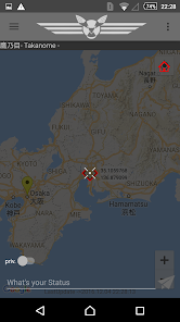
[Create marker]
Just specify any location on GoogleMap, add a comment and press the send button.
You can let other users know what is happening there.
Also, if you enable the GPS function of the terminal, you can quickly set your own location marker.
* * * * *
[Public marker and private marker]
Takanome classifies markers into two types.
1. Public Marker: "Anonymous", disclose information to all Takanome users
→ "There is an accident in the neighborhood and the surrounding area is congested." "The weather has suddenly worsened. An umbrella is needed.", "I'll do an event here!" Etc ... Information can be shared with all users who use Nome.
2. Private marker: Publish information only to users who have "Plug connection"
→ Use this when you want to specify a meeting place, try to let people know where you are, or publish information only to users who are plugged in.
* * * * *
[The marker disappears automatically]
・ You can delete your own markers at any time,
Public markers automatically disappear in 6 hours and private markers disappear in 12 hours.
忘 れ You will not forget to erase the marker or keep old information.
* * * * *
[Simple chat]
-Conversation with the user connected by plug is possible by simple chat.
た ら If you talk to a friend near you, your schedule for the day may change slightly.
ま す You can even use it just for regular communication and message.
--[Example of usage]------------------------------------- ------------------
-The meeting place is displayed on the map with the marker.
・ Indicate the location of the store you want to tell people on a map.
・ Notification of event venue.
-Share local road information, such as traffic jams, accidents, sudden construction and lane restrictions, in near real time.
・ When you get lost or get separated from your friends, mutually grasp the positions of yourself and your friends.
・ Use to confirm the safety of yourself and your family when a disaster occurs.
--[Future schedule (what you want to do)]--------------------------------------- ----------------------
・ Marker classification and search
→ Set categories for traffic conditions, weather conditions, emergency etc. markers to make it easier to identify on the Map.
→ Select and display only the markers of the desired category.
・ Common text creation function for comments attached to markers
→ Simply select a pre-defined comment and save the trouble of inputting characters.
・ Group function
→ Group users who are "plugged"
・ Image support
い I want to support image attachment when creating a marker ...
・ Introduction of user icons
・ Emergency marker
→ A car broke down, had an accident, needed help because of an injury or sudden illness, a disaster occurred etc…
(It is best to request a road service or contact 119. It is under consideration as a function that can notify family and friends with specific location information)
・ Ultra-simple operation management mode with GoogleMapAPI closely linked to GPS
→ A separate license is required to use for the purpose of “mobile management”.
・ Current location automatic update mode
→ Update your location and status at set time intervals in conjunction with GPS.
This is also under investigation as it is likely to be included in the category of “mobile management”…
Users can grasp each other's current location and share the surrounding weather and road conditions.
Markers can be made public or private when they are created. It is safe even for private exchanges.
Markers can be placed on the map, which can be used to confirm safety in the event of a disaster or accident.
- - 【Overview】 - - - - - - - - - - - - - - - - - - - - - - - - - - - - - - - - - - - - - - - - - - - - - --------------------------
Takanome is an application that works by providing information to each user.
Information from nearby users may be helpful, and your information may help other users.
For example,
・ If you indicate where to meet on the map, you won't have to get lost in the city you visited for the first time, and you can find friends in the crowd.
-If you indicate the location where traffic jams are occurring, nearby users can avoid traffic jams.
・ If you start Takanome at a solo touring destination that you went out to, you may have friends nearby.
・ It may be used for announcement of where the event starts.
・ If you have a disaster, you can inform your family of your safety with detailed location. (If the communication infrastructure is operating stably after the disaster, but ...)
Why don't you join Takanome user?
You can use it just by installing it on your smartphone and deciding your favorite ID.
--[Main functions]------------------------------------- ---------------------------
[Plug connection]
Takanome users can be "plugged".
"Plug connection" is a relationship equivalent to "Friends" or "Friends" of other services.
Only users who have plugged in can share location information and use the chat function.
* * * * *
[Create marker]
Just specify any location on GoogleMap, add a comment and press the send button.
You can let other users know what is happening there.
Also, if you enable the GPS function of the terminal, you can quickly set your own location marker.
* * * * *
[Public marker and private marker]
Takanome classifies markers into two types.
1. Public Marker: "Anonymous", disclose information to all Takanome users
→ "There is an accident in the neighborhood and the surrounding area is congested." "The weather has suddenly worsened. An umbrella is needed.", "I'll do an event here!" Etc ... Information can be shared with all users who use Nome.
2. Private marker: Publish information only to users who have "Plug connection"
→ Use this when you want to specify a meeting place, try to let people know where you are, or publish information only to users who are plugged in.
* * * * *
[The marker disappears automatically]
・ You can delete your own markers at any time,
Public markers automatically disappear in 6 hours and private markers disappear in 12 hours.
忘 れ You will not forget to erase the marker or keep old information.
* * * * *
[Simple chat]
-Conversation with the user connected by plug is possible by simple chat.
た ら If you talk to a friend near you, your schedule for the day may change slightly.
ま す You can even use it just for regular communication and message.
--[Example of usage]------------------------------------- ------------------
-The meeting place is displayed on the map with the marker.
・ Indicate the location of the store you want to tell people on a map.
・ Notification of event venue.
-Share local road information, such as traffic jams, accidents, sudden construction and lane restrictions, in near real time.
・ When you get lost or get separated from your friends, mutually grasp the positions of yourself and your friends.
・ Use to confirm the safety of yourself and your family when a disaster occurs.
--[Future schedule (what you want to do)]--------------------------------------- ----------------------
・ Marker classification and search
→ Set categories for traffic conditions, weather conditions, emergency etc. markers to make it easier to identify on the Map.
→ Select and display only the markers of the desired category.
・ Common text creation function for comments attached to markers
→ Simply select a pre-defined comment and save the trouble of inputting characters.
・ Group function
→ Group users who are "plugged"
・ Image support
い I want to support image attachment when creating a marker ...
・ Introduction of user icons
・ Emergency marker
→ A car broke down, had an accident, needed help because of an injury or sudden illness, a disaster occurred etc…
(It is best to request a road service or contact 119. It is under consideration as a function that can notify family and friends with specific location information)
・ Ultra-simple operation management mode with GoogleMapAPI closely linked to GPS
→ A separate license is required to use for the purpose of “mobile management”.
・ Current location automatic update mode
→ Update your location and status at set time intervals in conjunction with GPS.
This is also under investigation as it is likely to be included in the category of “mobile management”…
Updated on
Data safety
Developers can show information here about how their app collects and uses your data. Learn more about data safety

No information available
What's new
プライバシーポリシーを公開しました。
アプリの[Settings]->[プライバシーポリシー]で確認できます。
アプリの[Settings]->[プライバシーポリシー]で確認できます。