小平市防災マップ
4.2star
15 reviews
1K+
Downloads

Everyone
info
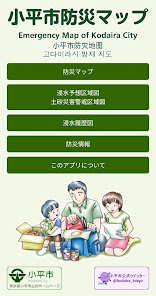
About this app
"Kodaira City Disaster Prevention Map App" is an application that allows you to view the "Kodaira City Disaster Prevention Map" on your smartphone.
Even if you do not have an internet connection, you can use GPS to check the nearest evacuation site.
We also provide information on daily preparations, things to keep in mind during disasters, and how to confirm the safety of your family, so please use this information to prepare for disasters.
[Features]
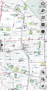
■Functional map
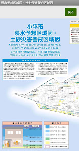
- A map that visually displays disaster prevention-related facilities using pictograms is used as a background map.
You can intuitively understand the layout of disaster prevention-related facilities.
- When online, it is possible to switch the distributed map service to a background map.
It is now possible to display a map outside Kodaira City, and it can also be used from outside the city.
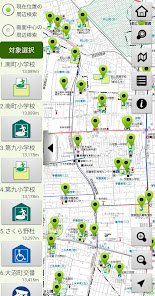
■Abundant search
・Facility search
Displays the facility selected from the facility list on the map.
Also, by entering part of the facility name, the selection will be narrowed down and displayed.
It is also possible to narrow down your search by facility type.
・Address search
Displays a map of the area selected from the town list or Oaza list within the city.
・Nearby search
Displays a list of facilities in order of distance from the current location (when using GPS) or the center of the displayed map.
■Convenient guidance display to the target point
- Directs you by connecting a line from your current location (when using GPS) or the center of the displayed map to the facility you have selected as a target.
- When online, you can launch a map app and search for a route from your current location to your goal.
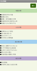
[Disaster prevention information]
To prepare for disasters, we provide the following disaster prevention information.
·Earthquake countermeasures
・Fire measures
・Countermeasures against wind and flood damage
・Comprehensive measures
=================
[Provider information]
Disaster prevention information: Kodaira City
Map information: Kodaira City, Chuo Geomatics Co., Ltd.
Product development: Chuo Geomatics Co., Ltd.
[For use]
・The information on the "Kodaira City Disaster Prevention Map" published in this app is based on information as of March 2024.
・Please note that we cannot be held responsible for any problems that may occur when using this application product.
[Inquiries regarding disaster prevention maps and disaster prevention information]
Kodaira City Citizen Life Department Disaster Prevention and Safety Division
Even if you do not have an internet connection, you can use GPS to check the nearest evacuation site.
We also provide information on daily preparations, things to keep in mind during disasters, and how to confirm the safety of your family, so please use this information to prepare for disasters.
[Features]
■Functional map
- A map that visually displays disaster prevention-related facilities using pictograms is used as a background map.
You can intuitively understand the layout of disaster prevention-related facilities.
- When online, it is possible to switch the distributed map service to a background map.
It is now possible to display a map outside Kodaira City, and it can also be used from outside the city.
■Abundant search
・Facility search
Displays the facility selected from the facility list on the map.
Also, by entering part of the facility name, the selection will be narrowed down and displayed.
It is also possible to narrow down your search by facility type.
・Address search
Displays a map of the area selected from the town list or Oaza list within the city.
・Nearby search
Displays a list of facilities in order of distance from the current location (when using GPS) or the center of the displayed map.
■Convenient guidance display to the target point
- Directs you by connecting a line from your current location (when using GPS) or the center of the displayed map to the facility you have selected as a target.
- When online, you can launch a map app and search for a route from your current location to your goal.
[Disaster prevention information]
To prepare for disasters, we provide the following disaster prevention information.
·Earthquake countermeasures
・Fire measures
・Countermeasures against wind and flood damage
・Comprehensive measures
=================
[Provider information]
Disaster prevention information: Kodaira City
Map information: Kodaira City, Chuo Geomatics Co., Ltd.
Product development: Chuo Geomatics Co., Ltd.
[For use]
・The information on the "Kodaira City Disaster Prevention Map" published in this app is based on information as of March 2024.
・Please note that we cannot be held responsible for any problems that may occur when using this application product.
[Inquiries regarding disaster prevention maps and disaster prevention information]
Kodaira City Citizen Life Department Disaster Prevention and Safety Division
Updated on
Safety starts with understanding how developers collect and share your data. Data privacy and security practices may vary based on your use, region, and age. The developer provided this information and may update it over time.

No data shared with third parties
Learn more about how developers declare sharing

No data collected
Learn more about how developers declare collection
Ratings and reviews
4.2
15 reviews
What's new
・避難者カードダウンロードボタンの追加
・地図データの更新
・防災情報の更新
・地図データの更新
・防災情報の更新


