
天サイ!まなぶくん茅ヶ崎版 防災情報可視化ARアプリ
4.4star
7 reviews
1K+
Downloads

Everyone
info
About this app
In conjunction with GPS information, the disaster prevention information of your current location is combined with the live-action video taken by the camera.
[About the recording area]
This application is an application that AR displays the tsunami inundation depth information of "Chigasaki City, Kanagawa Prefecture", the probability of passing through the area, the road blockage rate, the risk of building collapse, the risk of fire, and the risk of liquefaction.
[About the operation method]
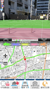
When started, the camera image is displayed in the upper half of the screen, the map is displayed in the lower half, and the hazard information is combined and displayed in the landscape. I am using a gyro and a compass, and when I move the terminal, the displayed contents change according to the direction, and disaster prevention information in the direction I am currently looking at is displayed.
The degree of risk is color-coded in 5 levels, and the color is superimposed on the ground of the live-action landscape on the camera live-action screen above.
The legend is displayed at the top of the live-action screen, and the map at the bottom half of the screen can be moved by touch operation. You can zoom in and out on the map with a two-finger pinch-in / pinch-out operation. When it starts up, GPS detects the position of the terminal and the map displays the current location. When you move the map by touch operation, GPS is automatically turned off and you can move the map from your current location. By pressing the current location button, you can reposition your current location from GPS.
[Details of disaster prevention information]
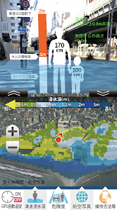
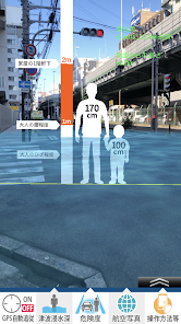
1. AR tsunami inundation depth information display
When you press the [Inundation Depth] button, the expected tsunami depth is displayed in the live-action video. In Kanagawa Prefecture, tsunami inundation forecasts are created for 12 earthquakes with different epicenters. Among them, the maximum inundation depth (inundation) at each point is compared with the tsunami inundation forecast maps of the Keicho-type earthquake, Genroku-type Kanto earthquake, and the Kaminawa / Kouzu and Minami-Kanto earthquakes, which are expected to cause great damage to Chigasaki city. Depth of earthquake) is shown.
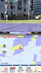
2. Probability of passing through the AR area
It refers to the ease of movement and passage of vehicles in each town and the ease of evacuation and passage of people after an earthquake. Specifically, we will measure the ease of entry of emergency vehicles into the area and the ease of evacuation of people from the area.
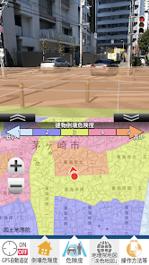
3. AR road blockage rate
This is a measurement of the risk of road blockage due to the collapse of roadside buildings.
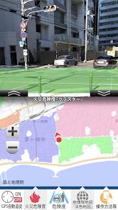
Four. AR fire risk information display
The fire broke out from the building and the risk of spreading the fire was measured and displayed. The measurement results show the buildings that will eventually burn down if the fire called "cluster" is left unattended in the same color.
Five. AR building collapse risk information display
Similarly, the risk of collapse of a building that requires caution in the event of an earthquake is displayed. The risk of a building collapsing due to shaking caused by an earthquake or liquefaction of the ground is measured using data such as the structure of the building and the age of the building.
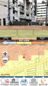
6. Liquefaction risk
The risk of liquefaction is expressed in 3 stages. The liquefaction risk of this application is the terrain
Calculation using "land conditions" determined by the presence or absence of artificially modified land and the results of geological surveys
The evaluation was made by combining the "PL value" that indicates the degree of liquefaction risk required by.
[Precautions for use]
This app is not intended to be used in the event of a disaster, but is designed to be used in advance as a preparation for daily disaster prevention.
In the event of an actual earthquake or disaster, it may exceed or fall below expectations depending on the scale. Regardless of the area displayed on the app, if there is a risk of fire or collapse due to an earthquake, please act at your own risk.
[About supervision]
Supervisor Professor Takaaki Kato, Institute of Industrial Science, University of Tokyo
Firefighting and Disaster Prevention Science and Technology Research Promotion System Developed as part of the 2011 agenda "Building a" Regional Disaster Prevention Assistance Technology Package "that draws out regional power and enhances sustainability" (Research Leaders Takaaki Kato, Chigasaki City)
Inquiries about "Tensai! Manabu-kun" Chigasaki version
Chigasaki City Urban Policy Division
toshiseisaku@city.chigasaki.kanagawa.jp
What is AR Hazard Scope? ]
Click here for inquiries about AR Hazard Scope
Cad Center Co., Ltd.
https://www.cadcenter.co.jp/products/archives/7
* "AR Hazard Scope" is a trademark of our company.
[About the recording area]
This application is an application that AR displays the tsunami inundation depth information of "Chigasaki City, Kanagawa Prefecture", the probability of passing through the area, the road blockage rate, the risk of building collapse, the risk of fire, and the risk of liquefaction.
[About the operation method]
When started, the camera image is displayed in the upper half of the screen, the map is displayed in the lower half, and the hazard information is combined and displayed in the landscape. I am using a gyro and a compass, and when I move the terminal, the displayed contents change according to the direction, and disaster prevention information in the direction I am currently looking at is displayed.
The degree of risk is color-coded in 5 levels, and the color is superimposed on the ground of the live-action landscape on the camera live-action screen above.
The legend is displayed at the top of the live-action screen, and the map at the bottom half of the screen can be moved by touch operation. You can zoom in and out on the map with a two-finger pinch-in / pinch-out operation. When it starts up, GPS detects the position of the terminal and the map displays the current location. When you move the map by touch operation, GPS is automatically turned off and you can move the map from your current location. By pressing the current location button, you can reposition your current location from GPS.
[Details of disaster prevention information]
1. AR tsunami inundation depth information display
When you press the [Inundation Depth] button, the expected tsunami depth is displayed in the live-action video. In Kanagawa Prefecture, tsunami inundation forecasts are created for 12 earthquakes with different epicenters. Among them, the maximum inundation depth (inundation) at each point is compared with the tsunami inundation forecast maps of the Keicho-type earthquake, Genroku-type Kanto earthquake, and the Kaminawa / Kouzu and Minami-Kanto earthquakes, which are expected to cause great damage to Chigasaki city. Depth of earthquake) is shown.
2. Probability of passing through the AR area
It refers to the ease of movement and passage of vehicles in each town and the ease of evacuation and passage of people after an earthquake. Specifically, we will measure the ease of entry of emergency vehicles into the area and the ease of evacuation of people from the area.
3. AR road blockage rate
This is a measurement of the risk of road blockage due to the collapse of roadside buildings.
Four. AR fire risk information display
The fire broke out from the building and the risk of spreading the fire was measured and displayed. The measurement results show the buildings that will eventually burn down if the fire called "cluster" is left unattended in the same color.
Five. AR building collapse risk information display
Similarly, the risk of collapse of a building that requires caution in the event of an earthquake is displayed. The risk of a building collapsing due to shaking caused by an earthquake or liquefaction of the ground is measured using data such as the structure of the building and the age of the building.
6. Liquefaction risk
The risk of liquefaction is expressed in 3 stages. The liquefaction risk of this application is the terrain
Calculation using "land conditions" determined by the presence or absence of artificially modified land and the results of geological surveys
The evaluation was made by combining the "PL value" that indicates the degree of liquefaction risk required by.
[Precautions for use]
This app is not intended to be used in the event of a disaster, but is designed to be used in advance as a preparation for daily disaster prevention.
In the event of an actual earthquake or disaster, it may exceed or fall below expectations depending on the scale. Regardless of the area displayed on the app, if there is a risk of fire or collapse due to an earthquake, please act at your own risk.
[About supervision]
Supervisor Professor Takaaki Kato, Institute of Industrial Science, University of Tokyo
Firefighting and Disaster Prevention Science and Technology Research Promotion System Developed as part of the 2011 agenda "Building a" Regional Disaster Prevention Assistance Technology Package "that draws out regional power and enhances sustainability" (Research Leaders Takaaki Kato, Chigasaki City)
Inquiries about "Tensai! Manabu-kun" Chigasaki version
Chigasaki City Urban Policy Division
toshiseisaku@city.chigasaki.kanagawa.jp
What is AR Hazard Scope? ]
Click here for inquiries about AR Hazard Scope
Cad Center Co., Ltd.
https://www.cadcenter.co.jp/products/archives/7
* "AR Hazard Scope" is a trademark of our company.
Updated on
Safety starts with understanding how developers collect and share your data. Data privacy and security practices may vary based on your use, region, and age. The developer provided this information and may update it over time.

No data shared with third parties
Learn more about how developers declare sharing

No data collected
Learn more about how developers declare collection
Ratings and reviews
4.4
7 reviews
What's new
軽微な修正
App support
phone
Phone number
+81332227841


