山と高原地図ホーダイ - 登山地図ナビアプリ
In-app purchases
50K+
Downloads

Everyone
info

About this app
■Notice of 2024 edition release■
The 2024 version of the 63 area map has been updated.
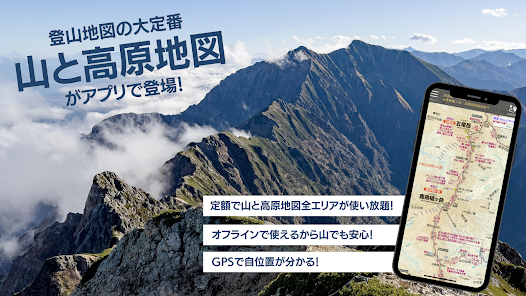
■Main features
① Find out your current location using your smartphone's location information!
You can easily find your location on the "Mountain and Highland Map", so it's easy to check your current location while climbing.
It is safe as a countermeasure in case of an emergency such as getting lost or in distress.
② Unlimited use of ``Mountain and Highland Maps'' in 63 areas for a fixed fee (500 yen/month or 4,800 yen/year)
Enrich your mountain climbing life with a mountain climbing map that includes all of the ``Japan's 100 Famous Mountains'' selected by Hisaya Fukada, as well as other major mountain areas.
③Free for 7 days from your first subscription
First, try the "Mountain and Plateau Map" for free.
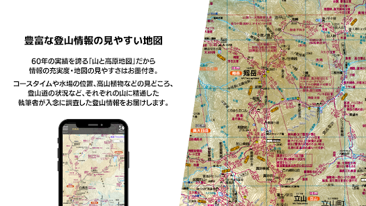
④A wealth of information that the author has actually researched on foot
It is full of the latest mountaineering information, including course times, locations of water holes, highlights such as alpine plants, and mountain trail conditions, based on actual on-site research carried out by authors who are familiar with each mountain.
The "Mountain and Plateau Map" boasts a proven track record of over 60 years, so the map is guaranteed to be easy to read!
*In consideration of ease of viewing on the smartphone app, changes have been made such as the topography representation and the omission of latitude and longitude lines.
⑤Can be used even outside the service area!
The map can be downloaded in advance and saved on your smartphone, so you can use it even in the mountains where there is no signal.
⑥You can record your climbing route!
You can record the location information you walk while climbing as a climbing route.
You can view the recorded routes on the app, send them via email to your computer, save and edit them, or post them on sites such as "Yamareco" to preserve your memories.
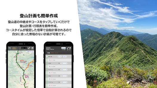
⑦You can easily plan your mountain climbing!
You can easily create a mountain climbing plan and itinerary just by tapping points on the map.
The course time will be automatically calculated based on the time multiplier you set, so you can make a reasonable plan that suits you.
⑧You can read the appendix booklet as an e-book!
You can read the appendix booklet with useful information such as the characteristics of the mountain area and course guides as an e-book.
■What is the publication “Mountain and Plateau Map”?
The "Mountain and Highland Map" series is a long-selling mountain climbing map that originated from "Mountain Map" published in 1965.
For each product, mountain professionals who are familiar with the area conduct on-site surveys, and based on the results, we revise it every year.As Japan's only nationwide mountaineering map series, we have achieved stable popularity. .
It has gained a reputation as a must-have map for mountain climbing due to its accuracy of information, easy-to-read map, display of course times and dangerous spots, comprehensive access information and appendices, and use of waterproof paper, and has established itself as a safe and secure map brand. I am.
~An example of commitment~
・The map is made of water-resistant paper that does not tear easily even if it gets wet so that it can be used even in rainy weather.
There is also a varnishing process to prevent ink from bleeding.
・The author who is familiar with the mountain actually walks the site and investigates it.
- Express the difficulty of the mountain climbing course by color, solid/dashed lines, approximate course time, etc.
・Full of information useful for safety and security during mountain climbing, such as mountain huts, water holes, dangerous spots, easy-to-get-lost places, landmarks, etc.
- Contains advice for enjoying mountain climbing, such as points for viewing flowers and alpine plants, and points for spectacular views.
- Also, the appendix booklet is packed with information that cannot be included on the map, such as the origin of the mountain's name, an overview, the climate of the mountain area, characteristics of animals and plants, and recommended courses.
■Recorded content
・Contains mountain climbing maps from the book map "Mountain and Highland Map".
(Parts of enlarged drawings, surrounding drawings, information published in the booklet, etc. are not included)
- lineup -
1 Rishiri, Rausu, Shiretoko, Shari, Akan, Rebun
2 Niseko, Mt. Yotei, Mt. Shokanbetsu, Mt. Komagatake
3 Daisetsuzan Mt. Tomuraushi, Mt. Tokachi, Mt. Horoshiri
4 Hakkoda, Mt. Iwaki, Mt. Shirakami, Lake Towada, Mt. Tashiro
5 Mt. Iwate, Mt. Hachimantai, Mt. Akita Komagatake, Mt. Himekami, Mt. Moriyoshi, Mt. Wagadake
6 Kurikoma/Mt. Hayachine Mt. Yaishishi/Mt. Kamuro
7 Zao Mt. Shiroyama/Mt. Funagata
8 Mt. Chokai/Mt. Gassan Mt. Haguro
9 Asahi Mountain Range: Mt. Itodake/Mt. Maya
10 Mt. Iide Mt. Susashidake/Dake Niojidake
11 Bandai/Azuma Tara Adachi
12 Nasu/Shiobara Mt. Takahara/Mt. Yamizo
13 Nikko Mt. Shirane/Mt. Nantai
14 Oze Mt. Hibutsu, Mt. Shibutsu, Mt. Aizukomagatake
15 Echigo Sanzan Hiragatake/Makikiyama
16 Mt. Tanigawa Mt. Naeba/Mt. Mutaka
17 Shiga Highlands, Mt. Kusatsu-Shirane and Mt. Shia
18 Myoko, Togakushi, Amakashi, Mt. Hiuchi, Mt. Takatsuma, Shinetsu Trail
19 Mt. Asama, mountains of Karuizawa and Naganohara
20 Akagi, Kokai, Haruna, Kesamaruyama, Ashio Mountains
21 Western Joshu Mt. Myogi/Mt. Arafune
22 Mt. Tsukuba/Mt. Kaba Mt. Takasuzu/Mt. Okukuji Nantai
23 Oku Musashi/Chichibu Mt. Buko
24 Okutama/Okuchichibu general map
25 Okutama Mt. Mitake/Mt. Otake
26 Great Bodhisattva Ridge
27 Mt. Kumotori/Mt. Ryokami
28 Kinpusan/Kobushin
29 Takao/Jinba
30 Miura/Boso
31 Tanzawa
32 Hakone Mt. Kintoki/Mt. Komagatake
33 Izu Mt. Amagi
34 Mt. Fuji, Misaka Mountains, Mt. Ashitaka
35 Yatsugatake Tateshina, Utsukushigahara, Kirigamine
36 General map of the Japanese Alps
37 Mt. Hakuba
38 Kashimayari/Mt. Goryu
39 Tsurugi/Tateyama
40 Yarigatake/Hotakatake Kamikochi
41 Norikura Highlands
42 Mt. Ontake, Mt. Kohide, Mt. Okusankai, Mt. Izan Sanzan
43 Kisokoma/Mt. Soraki
44 Kitadake/Kaikoma
45 Shiomi, Akaishi, Mt. Hijiri
46 Mt. Haku Mt. Arashima, Mt. Nogo Haku, Mt. Kongodo
47 Gozaisho/Reisen/Ibuki
48 Hira Mountain Range Mt. Bunagatake/Mt. Akasaka
49 Kyoto Kitayama
50 Hokusetsu, Kyoto Nishiyama, Minoh, Mt. Myoken, Nakayama, Tanba Sasayama
51 Rokko/Maya Suma Alps
52 Kongo, Katsuragi, Mt. Ikoma, Kisen Highlands
53 Mt. Koya/Kumano Kodo Obukodake
54 Omine Mountains
55 Odaigahara Mt. Takami/Mt. Torsonzan
56 Hyonoyama Hachibuse/Kami-nabe
57 Mt. Daisen/Hiruzen Plateau Mt. Sanbe/Mt. Hiba/Mt. Dogo
58 Ishizuchi/Shikoku Tsurugiyama Higashiakaishiyama/Mimine/Shikoku Mountain Crossing Trail
59 Mountains of Fukuoka Mt. Homan and Mt. Hiko
60 Aso/Konoe Yufudake
61 Grandmother Kan Okureyama
62 Kirishima/Mt. Kaimondake Mt. Ichifusa/Mt. Takakuma
63 Yakushima Mt. Miyanoura
■Compatible models/OS
・Android OS 5.0 or later (may not work on some models)
*Cannot be used on models that are not compatible with Play Store.
(Easy smartphones, Kindle devices, fire devices, etc.)
*If your device is not equipped with GPS, you cannot display your current location or record your route.
*GPS performance varies greatly depending on the model and OS.
■Regular subscription
・Monthly 500 yen (tax included) or annual discount 4800 yen (tax included)
You can try it for free for 7 days after your first registration.
*After the trial period ends, you will automatically be charged.
To use the following features, you need to apply for a regular subscription.
*Installation of the app itself is free.
① Download and display the mountain climbing map “Mountain and Highland Map”
②Creating a mountain climbing plan
Subscription prices are subject to change.
Please be sure to check the purchase screen before purchasing.
■About automatic renewal of subscriptions
・We use the automatic recurring billing function (Auto Renewable Subscription) for regular subscription tickets.
・Charging for automatic renewal will be done from 24 hours before the end of the validity period until the end of the period.
・From the Play Store menu, go to "Account Information" > "Regular Purchase" > "Mountains and Highlands Map Hodai" > "Management" > "Cancel Subscription". For detailed instructions, please see the "Usage Guide" within the app.
・When this app starts, it will check the subscription status by accessing the Play Store online.
・In case you are unable to renew the expiration date because you are out of the area, such as in the mountains, you can use the renewal grace period for 7 days from the date you last obtained billing information. Please note that after 8 days, you will no longer be able to use the subscription, even if it is within the expiration date of your subscription.
■Note
・Due to the large data size of index maps and mountain climbing maps, we recommend downloading them in a Wi-Fi environment.
・The function that records routes in the background consumes a lot of battery power. We recommend settings that conserve battery power to ensure a means of communication in case of an emergency. (Please refer to the in-app usage guide for setting method)
・Be sure to use the paper "Mountain and Highland Map" in preparation for unexpected situations such as battery running out.
・The investigation period for posted information is stated in "Help" > "Credit Notation" in the app. For the sake of research, some areas include their previous state. Also, the conditions of the mountain climbing area, such as the condition of mountain trails and the operation of facilities, may change significantly due to heavy rain, wind and snow, etc., so please make your own decisions and act carefully at your own risk. For your safety, please be sure to check the situation with the local government office before hiking.
・The posted information is not based on GPS positioning, so it may differ from the actual location.
Additionally, the accuracy of the location information that your smartphone can obtain may decrease depending on the surrounding topography.
Please make a comprehensive judgment based on not only your current location indicated by this app, but also the surrounding topography and other factors.
・Please note that we cannot be held responsible for any accidents or distress that occur while using this app.
The 2024 version of the 63 area map has been updated.
■Main features
① Find out your current location using your smartphone's location information!
You can easily find your location on the "Mountain and Highland Map", so it's easy to check your current location while climbing.
It is safe as a countermeasure in case of an emergency such as getting lost or in distress.
② Unlimited use of ``Mountain and Highland Maps'' in 63 areas for a fixed fee (500 yen/month or 4,800 yen/year)
Enrich your mountain climbing life with a mountain climbing map that includes all of the ``Japan's 100 Famous Mountains'' selected by Hisaya Fukada, as well as other major mountain areas.
③Free for 7 days from your first subscription
First, try the "Mountain and Plateau Map" for free.
④A wealth of information that the author has actually researched on foot
It is full of the latest mountaineering information, including course times, locations of water holes, highlights such as alpine plants, and mountain trail conditions, based on actual on-site research carried out by authors who are familiar with each mountain.
The "Mountain and Plateau Map" boasts a proven track record of over 60 years, so the map is guaranteed to be easy to read!
*In consideration of ease of viewing on the smartphone app, changes have been made such as the topography representation and the omission of latitude and longitude lines.
⑤Can be used even outside the service area!
The map can be downloaded in advance and saved on your smartphone, so you can use it even in the mountains where there is no signal.
⑥You can record your climbing route!
You can record the location information you walk while climbing as a climbing route.
You can view the recorded routes on the app, send them via email to your computer, save and edit them, or post them on sites such as "Yamareco" to preserve your memories.
⑦You can easily plan your mountain climbing!
You can easily create a mountain climbing plan and itinerary just by tapping points on the map.
The course time will be automatically calculated based on the time multiplier you set, so you can make a reasonable plan that suits you.
⑧You can read the appendix booklet as an e-book!
You can read the appendix booklet with useful information such as the characteristics of the mountain area and course guides as an e-book.
■What is the publication “Mountain and Plateau Map”?
The "Mountain and Highland Map" series is a long-selling mountain climbing map that originated from "Mountain Map" published in 1965.
For each product, mountain professionals who are familiar with the area conduct on-site surveys, and based on the results, we revise it every year.As Japan's only nationwide mountaineering map series, we have achieved stable popularity. .
It has gained a reputation as a must-have map for mountain climbing due to its accuracy of information, easy-to-read map, display of course times and dangerous spots, comprehensive access information and appendices, and use of waterproof paper, and has established itself as a safe and secure map brand. I am.
~An example of commitment~
・The map is made of water-resistant paper that does not tear easily even if it gets wet so that it can be used even in rainy weather.
There is also a varnishing process to prevent ink from bleeding.
・The author who is familiar with the mountain actually walks the site and investigates it.
- Express the difficulty of the mountain climbing course by color, solid/dashed lines, approximate course time, etc.
・Full of information useful for safety and security during mountain climbing, such as mountain huts, water holes, dangerous spots, easy-to-get-lost places, landmarks, etc.
- Contains advice for enjoying mountain climbing, such as points for viewing flowers and alpine plants, and points for spectacular views.
- Also, the appendix booklet is packed with information that cannot be included on the map, such as the origin of the mountain's name, an overview, the climate of the mountain area, characteristics of animals and plants, and recommended courses.
■Recorded content
・Contains mountain climbing maps from the book map "Mountain and Highland Map".
(Parts of enlarged drawings, surrounding drawings, information published in the booklet, etc. are not included)
- lineup -
1 Rishiri, Rausu, Shiretoko, Shari, Akan, Rebun
2 Niseko, Mt. Yotei, Mt. Shokanbetsu, Mt. Komagatake
3 Daisetsuzan Mt. Tomuraushi, Mt. Tokachi, Mt. Horoshiri
4 Hakkoda, Mt. Iwaki, Mt. Shirakami, Lake Towada, Mt. Tashiro
5 Mt. Iwate, Mt. Hachimantai, Mt. Akita Komagatake, Mt. Himekami, Mt. Moriyoshi, Mt. Wagadake
6 Kurikoma/Mt. Hayachine Mt. Yaishishi/Mt. Kamuro
7 Zao Mt. Shiroyama/Mt. Funagata
8 Mt. Chokai/Mt. Gassan Mt. Haguro
9 Asahi Mountain Range: Mt. Itodake/Mt. Maya
10 Mt. Iide Mt. Susashidake/Dake Niojidake
11 Bandai/Azuma Tara Adachi
12 Nasu/Shiobara Mt. Takahara/Mt. Yamizo
13 Nikko Mt. Shirane/Mt. Nantai
14 Oze Mt. Hibutsu, Mt. Shibutsu, Mt. Aizukomagatake
15 Echigo Sanzan Hiragatake/Makikiyama
16 Mt. Tanigawa Mt. Naeba/Mt. Mutaka
17 Shiga Highlands, Mt. Kusatsu-Shirane and Mt. Shia
18 Myoko, Togakushi, Amakashi, Mt. Hiuchi, Mt. Takatsuma, Shinetsu Trail
19 Mt. Asama, mountains of Karuizawa and Naganohara
20 Akagi, Kokai, Haruna, Kesamaruyama, Ashio Mountains
21 Western Joshu Mt. Myogi/Mt. Arafune
22 Mt. Tsukuba/Mt. Kaba Mt. Takasuzu/Mt. Okukuji Nantai
23 Oku Musashi/Chichibu Mt. Buko
24 Okutama/Okuchichibu general map
25 Okutama Mt. Mitake/Mt. Otake
26 Great Bodhisattva Ridge
27 Mt. Kumotori/Mt. Ryokami
28 Kinpusan/Kobushin
29 Takao/Jinba
30 Miura/Boso
31 Tanzawa
32 Hakone Mt. Kintoki/Mt. Komagatake
33 Izu Mt. Amagi
34 Mt. Fuji, Misaka Mountains, Mt. Ashitaka
35 Yatsugatake Tateshina, Utsukushigahara, Kirigamine
36 General map of the Japanese Alps
37 Mt. Hakuba
38 Kashimayari/Mt. Goryu
39 Tsurugi/Tateyama
40 Yarigatake/Hotakatake Kamikochi
41 Norikura Highlands
42 Mt. Ontake, Mt. Kohide, Mt. Okusankai, Mt. Izan Sanzan
43 Kisokoma/Mt. Soraki
44 Kitadake/Kaikoma
45 Shiomi, Akaishi, Mt. Hijiri
46 Mt. Haku Mt. Arashima, Mt. Nogo Haku, Mt. Kongodo
47 Gozaisho/Reisen/Ibuki
48 Hira Mountain Range Mt. Bunagatake/Mt. Akasaka
49 Kyoto Kitayama
50 Hokusetsu, Kyoto Nishiyama, Minoh, Mt. Myoken, Nakayama, Tanba Sasayama
51 Rokko/Maya Suma Alps
52 Kongo, Katsuragi, Mt. Ikoma, Kisen Highlands
53 Mt. Koya/Kumano Kodo Obukodake
54 Omine Mountains
55 Odaigahara Mt. Takami/Mt. Torsonzan
56 Hyonoyama Hachibuse/Kami-nabe
57 Mt. Daisen/Hiruzen Plateau Mt. Sanbe/Mt. Hiba/Mt. Dogo
58 Ishizuchi/Shikoku Tsurugiyama Higashiakaishiyama/Mimine/Shikoku Mountain Crossing Trail
59 Mountains of Fukuoka Mt. Homan and Mt. Hiko
60 Aso/Konoe Yufudake
61 Grandmother Kan Okureyama
62 Kirishima/Mt. Kaimondake Mt. Ichifusa/Mt. Takakuma
63 Yakushima Mt. Miyanoura
■Compatible models/OS
・Android OS 5.0 or later (may not work on some models)
*Cannot be used on models that are not compatible with Play Store.
(Easy smartphones, Kindle devices, fire devices, etc.)
*If your device is not equipped with GPS, you cannot display your current location or record your route.
*GPS performance varies greatly depending on the model and OS.
■Regular subscription
・Monthly 500 yen (tax included) or annual discount 4800 yen (tax included)
You can try it for free for 7 days after your first registration.
*After the trial period ends, you will automatically be charged.
To use the following features, you need to apply for a regular subscription.
*Installation of the app itself is free.
① Download and display the mountain climbing map “Mountain and Highland Map”
②Creating a mountain climbing plan
Subscription prices are subject to change.
Please be sure to check the purchase screen before purchasing.
■About automatic renewal of subscriptions
・We use the automatic recurring billing function (Auto Renewable Subscription) for regular subscription tickets.
・Charging for automatic renewal will be done from 24 hours before the end of the validity period until the end of the period.
・From the Play Store menu, go to "Account Information" > "Regular Purchase" > "Mountains and Highlands Map Hodai" > "Management" > "Cancel Subscription". For detailed instructions, please see the "Usage Guide" within the app.
・When this app starts, it will check the subscription status by accessing the Play Store online.
・In case you are unable to renew the expiration date because you are out of the area, such as in the mountains, you can use the renewal grace period for 7 days from the date you last obtained billing information. Please note that after 8 days, you will no longer be able to use the subscription, even if it is within the expiration date of your subscription.
■Note
・Due to the large data size of index maps and mountain climbing maps, we recommend downloading them in a Wi-Fi environment.
・The function that records routes in the background consumes a lot of battery power. We recommend settings that conserve battery power to ensure a means of communication in case of an emergency. (Please refer to the in-app usage guide for setting method)
・Be sure to use the paper "Mountain and Highland Map" in preparation for unexpected situations such as battery running out.
・The investigation period for posted information is stated in "Help" > "Credit Notation" in the app. For the sake of research, some areas include their previous state. Also, the conditions of the mountain climbing area, such as the condition of mountain trails and the operation of facilities, may change significantly due to heavy rain, wind and snow, etc., so please make your own decisions and act carefully at your own risk. For your safety, please be sure to check the situation with the local government office before hiking.
・The posted information is not based on GPS positioning, so it may differ from the actual location.
Additionally, the accuracy of the location information that your smartphone can obtain may decrease depending on the surrounding topography.
Please make a comprehensive judgment based on not only your current location indicated by this app, but also the surrounding topography and other factors.
・Please note that we cannot be held responsible for any accidents or distress that occur while using this app.
Updated on
Safety starts with understanding how developers collect and share your data. Data privacy and security practices may vary based on your use, region, and age. The developer provided this information and may update it over time.


What's new
・ヤマプラ連携機能を終了しました。


