乗換MAPナビ 全国の公共交通情報を網羅した総合ナビアプリ
Contains ads
3.9star
649 reviews
50K+
Downloads

Everyone
info

About this app
-------------------------------------------------- -----------------------
2024.2.29 ~ Version.9.4.9 Distribution start
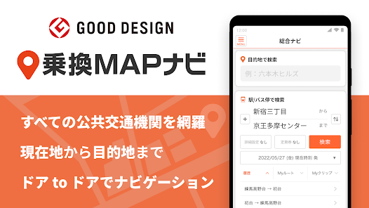
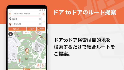
◆ Check traffic information and search for the best route for train & bus + walking route (door to door)! Guidance to your destination without fail!
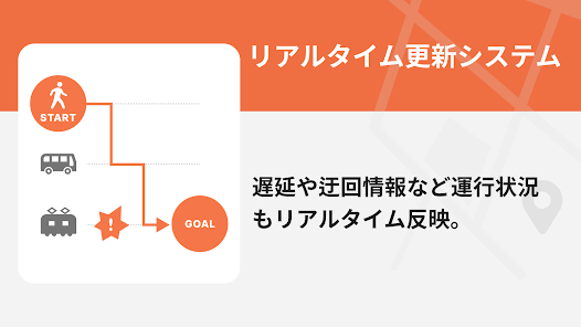
◆In addition to transfer information, bus, and walking route information from the nearest location, station information, surrounding maps, and operation information are displayed in conjunction. It also displays transit times at stations along the way, and is fully equipped with bus timetables from all over the country for free! The latest delay information is displayed on the route map every 5 minutes, and traffic congestion information is linked to VICS in almost real time, and the map is updated every 5 minutes nationwide and every 1 minute in the Tokyo metropolitan area!
◆Walking route search also supports crosswalks and roads in parks, and 3D map navigation function is also available!
-------------------------------------------------- -----------------------
Full of station exit information. The transfer results will guide you to the main facilities in the direction of the exit, allowing you to quickly find out the direction to your destination. Station area map/station area spot search provides convenient categories that are useful for daily life. Furthermore, we provide total support for destination guidance by linking with walking navigation and car navigation (charges apply) after getting off the train! Please download the app and use it!
-------------------------------------------------- -----------------------
``Life Ranger'', which provides ``Transfer Map Navi'', is a comprehensive lifestyle information service that provides useful information such as weather, transfer information, car and walking route information, traffic jam information, and railway operation information.
The "Transfer Map Navi" app is provided as part of Life Ranger's traffic information service.
Transfer MAP navigation function list
(1) Transfer information (comprehensive route) [Free]
・Displays passing times at stations along the way and timetables linked to buses.
・Departure/arrival times, departure number, boarding position convenient for transfers, and current location are also displayed in the navigation.
・You can also check the previous and next search.
・You can also check surrounding information and exit information for transfer stations and arrival stations.
・If you miss your train, you can also check the timetable with one touch.
・Suggest detour routes while obtaining real-time operation information
・Supports commuter pass searches to check commuter fares, and searches that take commuter passes into consideration when you want to go at the cheapest price.
(2) MAP display [Free]
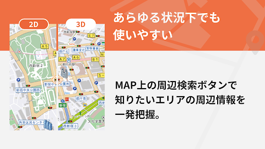
- Elaborately display Super Mapple road maps using 3D icons
・Supports 2D/3D switching display and automatic day/night mode switching
・Supports MAP customization function that allows you to display your favorite icons on the map
・One-touch support for MAP automatic rotation display and north up display switching
・Immediately grasp the surrounding information of the area you want to know by pressing the surrounding search button on the MAP
(3) Nearby search [Free]
・We have prepared various category spots such as stations, bus stops, convenience stores, restaurants, cafes, 100 yen shops, drug stores, fast food, banks, and parking lots (with Times24, Repark/vacancy information) near your current location. You can narrow down your search using any genre or free word.
(4) Train/bus timetable [Free]
・Search timetables for stations/bus stops nationwide
・You can search the timetable of the nearest station/bus stop from your current location with one touch.
・Supports display of transit times at arrival stations and bus stops
(5) Route map/operation information [Free]
・Display real-time nationwide railway operation information on the route map
・You can instantly check not only delays, suspensions, and suspension of operations, but also recovery information.
・You can also check real-time delay status from the national route map
(6) Walking + train navigation [Free]
・Shortest route to the nearest station + navigation
・If you want to change the nearest station based on the walking + train route results, you can change the route in one go.
・Route guidance is easy to understand with 3D map display, and a reroute function is also included in case you deviate from the road.
・You can search for recommended spots near your destination! Includes spot detailed guide information
・You can navigate the walking route after getting off the train with one-touch switching.
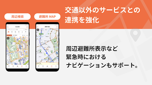
(7) Evacuation center MAP + navigation [Free]
・You can search nearby evacuation centers + navigation, and check the walking route to your home.
---- The following can be used after paid registration ----
(8) Map display of traffic congestion/traffic information: Simple map of high-speed traffic congestion
・Display real-time VICS traffic congestion information and regulation information on the map
・Detailed VICS traffic information and regulation information is also displayed on the car navigation map.
・In the Shuto Expressway area, traffic congestion information is updated every minute.
(9) Car navigation
・Reading intersection names and detailed voice guidance for going straight and turning left and right
・Supports auto-reroute function that takes into account real-time VICS traffic information
・Voice support for construction, lane restriction guidance, and broken vehicle information
- Illustrated display of toll road entrances, highway junctions, etc.
・Display direction signs and driving lane information for general roads
・Supports Orbis alerts with audio and icon display on the map
■Price
Downloading the app is free. (Functions other than those related to car navigation and traffic congestion information can be used for free.)
To use all features, you need to register for a paid ticket.
■Compatible terminals (OS)
AndroidOS 10 or higher (AndroidOS 11 or higher devices recommended)
・Please note that the navigation function will not work properly on devices that are not equipped with GPS.
■Notes
-The information provided in this app may differ from the actual information. Please use the app as reference information.
・When using the navigation (car navigation) function, please drive according to the actual road conditions and traffic rules.
- Operating the app while moving may lead to an accident. Please be sure to stop in a safe place before operating the vehicle, or have a passenger operate the vehicle.
・We are not responsible for any accidents or business-related damages caused by using this app.
・Even if registered information is lost due to a failure, our company cannot be held responsible in any way.
・GPS reception may not be possible or accurate location may not be determined depending on the location, such as inside buildings or tunnels. Please note.
・During navigation, positioning continues even in the background. In this case, the battery consumption may be higher than usual, so we recommend that you use it in a state where it is fully charged or can be constantly powered by a cigarette lighter power source.
2024.2.29 ~ Version.9.4.9 Distribution start
◆ Check traffic information and search for the best route for train & bus + walking route (door to door)! Guidance to your destination without fail!
◆In addition to transfer information, bus, and walking route information from the nearest location, station information, surrounding maps, and operation information are displayed in conjunction. It also displays transit times at stations along the way, and is fully equipped with bus timetables from all over the country for free! The latest delay information is displayed on the route map every 5 minutes, and traffic congestion information is linked to VICS in almost real time, and the map is updated every 5 minutes nationwide and every 1 minute in the Tokyo metropolitan area!
◆Walking route search also supports crosswalks and roads in parks, and 3D map navigation function is also available!
-------------------------------------------------- -----------------------
Full of station exit information. The transfer results will guide you to the main facilities in the direction of the exit, allowing you to quickly find out the direction to your destination. Station area map/station area spot search provides convenient categories that are useful for daily life. Furthermore, we provide total support for destination guidance by linking with walking navigation and car navigation (charges apply) after getting off the train! Please download the app and use it!
-------------------------------------------------- -----------------------
``Life Ranger'', which provides ``Transfer Map Navi'', is a comprehensive lifestyle information service that provides useful information such as weather, transfer information, car and walking route information, traffic jam information, and railway operation information.
The "Transfer Map Navi" app is provided as part of Life Ranger's traffic information service.
Transfer MAP navigation function list
(1) Transfer information (comprehensive route) [Free]
・Displays passing times at stations along the way and timetables linked to buses.
・Departure/arrival times, departure number, boarding position convenient for transfers, and current location are also displayed in the navigation.
・You can also check the previous and next search.
・You can also check surrounding information and exit information for transfer stations and arrival stations.
・If you miss your train, you can also check the timetable with one touch.
・Suggest detour routes while obtaining real-time operation information
・Supports commuter pass searches to check commuter fares, and searches that take commuter passes into consideration when you want to go at the cheapest price.
(2) MAP display [Free]
- Elaborately display Super Mapple road maps using 3D icons
・Supports 2D/3D switching display and automatic day/night mode switching
・Supports MAP customization function that allows you to display your favorite icons on the map
・One-touch support for MAP automatic rotation display and north up display switching
・Immediately grasp the surrounding information of the area you want to know by pressing the surrounding search button on the MAP
(3) Nearby search [Free]
・We have prepared various category spots such as stations, bus stops, convenience stores, restaurants, cafes, 100 yen shops, drug stores, fast food, banks, and parking lots (with Times24, Repark/vacancy information) near your current location. You can narrow down your search using any genre or free word.
(4) Train/bus timetable [Free]
・Search timetables for stations/bus stops nationwide
・You can search the timetable of the nearest station/bus stop from your current location with one touch.
・Supports display of transit times at arrival stations and bus stops
(5) Route map/operation information [Free]
・Display real-time nationwide railway operation information on the route map
・You can instantly check not only delays, suspensions, and suspension of operations, but also recovery information.
・You can also check real-time delay status from the national route map
(6) Walking + train navigation [Free]
・Shortest route to the nearest station + navigation
・If you want to change the nearest station based on the walking + train route results, you can change the route in one go.
・Route guidance is easy to understand with 3D map display, and a reroute function is also included in case you deviate from the road.
・You can search for recommended spots near your destination! Includes spot detailed guide information
・You can navigate the walking route after getting off the train with one-touch switching.
(7) Evacuation center MAP + navigation [Free]
・You can search nearby evacuation centers + navigation, and check the walking route to your home.
---- The following can be used after paid registration ----
(8) Map display of traffic congestion/traffic information: Simple map of high-speed traffic congestion
・Display real-time VICS traffic congestion information and regulation information on the map
・Detailed VICS traffic information and regulation information is also displayed on the car navigation map.
・In the Shuto Expressway area, traffic congestion information is updated every minute.
(9) Car navigation
・Reading intersection names and detailed voice guidance for going straight and turning left and right
・Supports auto-reroute function that takes into account real-time VICS traffic information
・Voice support for construction, lane restriction guidance, and broken vehicle information
- Illustrated display of toll road entrances, highway junctions, etc.
・Display direction signs and driving lane information for general roads
・Supports Orbis alerts with audio and icon display on the map
■Price
Downloading the app is free. (Functions other than those related to car navigation and traffic congestion information can be used for free.)
To use all features, you need to register for a paid ticket.
■Compatible terminals (OS)
AndroidOS 10 or higher (AndroidOS 11 or higher devices recommended)
・Please note that the navigation function will not work properly on devices that are not equipped with GPS.
■Notes
-The information provided in this app may differ from the actual information. Please use the app as reference information.
・When using the navigation (car navigation) function, please drive according to the actual road conditions and traffic rules.
- Operating the app while moving may lead to an accident. Please be sure to stop in a safe place before operating the vehicle, or have a passenger operate the vehicle.
・We are not responsible for any accidents or business-related damages caused by using this app.
・Even if registered information is lost due to a failure, our company cannot be held responsible in any way.
・GPS reception may not be possible or accurate location may not be determined depending on the location, such as inside buildings or tunnels. Please note.
・During navigation, positioning continues even in the background. In this case, the battery consumption may be higher than usual, so we recommend that you use it in a state where it is fully charged or can be constantly powered by a cigarette lighter power source.
Updated on
Safety starts with understanding how developers collect and share your data. Data privacy and security practices may vary based on your use, region, and age. The developer provided this information and may update it over time.

No data shared with third parties
Learn more about how developers declare sharing

This app may collect these data types
App activity

Data isn’t encrypted

You can request that data be deleted
Ratings and reviews
3.9
649 reviews


