
iHighway交通情報
3.9star
6.18K reviews
1M+
Downloads

Everyone
info
About this app
I-Highway is a service that provides traffic information on expressways nationwide. Please use it to consider driving plans such as departure time, driving route, and selection of resting places when using the expressway, and also to collect information when traffic is closed.
--------------------
Main functions
--------------------
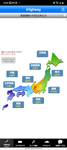
▼ Traffic situation map
You can check the latest traffic information such as road closures and traffic jams on the map at a glance. (Information is updated for 5 minutes.)
▼ Notification of cancellation of traffic closure by email
You can receive an email when the road closure you care about is lifted.
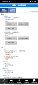
▼ Traffic closure work information
You can check the work status for lifting the road closure. (This is a service unique to the NEXCO West Japan area.)
▼ Heavy rain information
If there is a possibility of heavy rain that will cause traffic closures or traffic restrictions, you can see at a glance which sections need caution. (This is a service unique to the NEXCO West Japan area. It is provided from mid-April to mid-November)
▼ Snow road information
You can check traffic information specialized for snowy roads and the current weather and road surface conditions. (This is a service unique to the NEXCO West Japan area. Provided from mid-November to mid-April: Winter only)
▼ IC entrance / exit (ramp) closure information
You can check the information of the ramp closure (the inflow from the IC entrance to the main line or the outflow from the main line to the IC exit is not possible).
▼ Addition of transit IC information
When an ETC vehicle is closed, you can check the "outflow designated IC" and "re-transfer target IC" that automatically adjust the fare by connecting and continue the discount conditions. (This is a service unique to the NEXCO West Japan area.)
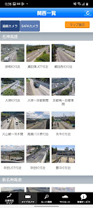
▼ Live camera
You can check the current state of the expressway and SA / PA with live camera images before departure. (Live cameras in the West Japan area are available all year round, and other areas are limited to winter except for some areas.)
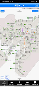
▼ Route search
You can check the regulatory information occurring in the searched road or route.
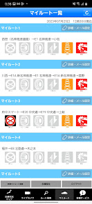
▼ My route function
If you register frequently used routes / sections as My Routes, you can check the latest information with one tap. In addition, it is possible to receive information on traffic jams and traffic jams on My Route by e-mail.
・ Regular email
・ Real-time email
-When the road is closed
-When the road closure is lifted
-When an accident occurs with traffic congestion
-When heavy rain is wary
* Winter only
・ Real-time email
-At the time of chain regulation
-When chain regulation is lifted
-When it is necessary to install winter tires, etc.
-When dismounting winter tires, etc.
・ Snow road support email
--------------------
Recommended environment
--------------------
Android OS 5.0 and above
* However, it may not work properly on some models.
*********************
please note
*********************
・ It is prohibited by the Road Traffic Act to operate or gaze at mobile phones while driving.
・ Please use it by a passenger or park your car in a safe place such as SA / PA on the highway.
・ Internet connection is required to use the application. It cannot be used offline (when not connected to the network).
--------------------
Main functions
--------------------
▼ Traffic situation map
You can check the latest traffic information such as road closures and traffic jams on the map at a glance. (Information is updated for 5 minutes.)
▼ Notification of cancellation of traffic closure by email
You can receive an email when the road closure you care about is lifted.
▼ Traffic closure work information
You can check the work status for lifting the road closure. (This is a service unique to the NEXCO West Japan area.)
▼ Heavy rain information
If there is a possibility of heavy rain that will cause traffic closures or traffic restrictions, you can see at a glance which sections need caution. (This is a service unique to the NEXCO West Japan area. It is provided from mid-April to mid-November)
▼ Snow road information
You can check traffic information specialized for snowy roads and the current weather and road surface conditions. (This is a service unique to the NEXCO West Japan area. Provided from mid-November to mid-April: Winter only)
▼ IC entrance / exit (ramp) closure information
You can check the information of the ramp closure (the inflow from the IC entrance to the main line or the outflow from the main line to the IC exit is not possible).
▼ Addition of transit IC information
When an ETC vehicle is closed, you can check the "outflow designated IC" and "re-transfer target IC" that automatically adjust the fare by connecting and continue the discount conditions. (This is a service unique to the NEXCO West Japan area.)
▼ Live camera
You can check the current state of the expressway and SA / PA with live camera images before departure. (Live cameras in the West Japan area are available all year round, and other areas are limited to winter except for some areas.)
▼ Route search
You can check the regulatory information occurring in the searched road or route.
▼ My route function
If you register frequently used routes / sections as My Routes, you can check the latest information with one tap. In addition, it is possible to receive information on traffic jams and traffic jams on My Route by e-mail.
・ Regular email
・ Real-time email
-When the road is closed
-When the road closure is lifted
-When an accident occurs with traffic congestion
-When heavy rain is wary
* Winter only
・ Real-time email
-At the time of chain regulation
-When chain regulation is lifted
-When it is necessary to install winter tires, etc.
-When dismounting winter tires, etc.
・ Snow road support email
--------------------
Recommended environment
--------------------
Android OS 5.0 and above
* However, it may not work properly on some models.
*********************
please note
*********************
・ It is prohibited by the Road Traffic Act to operate or gaze at mobile phones while driving.
・ Please use it by a passenger or park your car in a safe place such as SA / PA on the highway.
・ Internet connection is required to use the application. It cannot be used offline (when not connected to the network).
Updated on
Safety starts with understanding how developers collect and share your data. Data privacy and security practices may vary based on your use, region, and age. The developer provided this information and may update it over time.

No data shared with third parties
Learn more about how developers declare sharing

This app may collect these data types
Personal info

Data is encrypted in transit

You can request that data be deleted
Ratings and reviews
3.9
6.18K reviews
What's new
■更新情報
-軽微な修正を行いました
-軽微な修正を行いました