
Aero XC : weather for flying
In-app purchases
4.6star
649 reviews
10K+
Downloads

Everyone
info


About this app
Weather forecast with an extensive vertical profile. For flying and professionals.
Do you want to know what the wind will blow at height or at the ground?
Would you like to go soaring or are you looking for proper thermals?
Do you fly paragliding, rogalo or ultralight or maybe with something bigger?
Then this application is for you.
Aero XC displays forecast information as easily as possible.
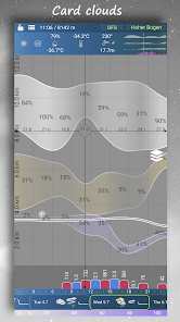
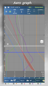
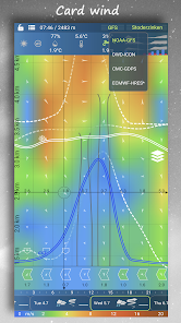
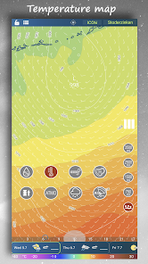
In a clear vertical profile from the ground up to a height of about 12 km, the basic parameters such as force (color scale is adapted to flying) and wind direction, gusts and temperature, humidity and dew point are displayed.
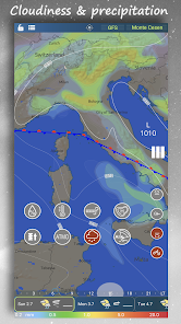
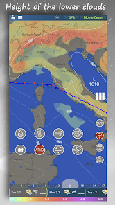
Furthermore, the power and height of instability, convection condensation level, zero isotherm and clouds of all floors on a scale. The cloud floors are color-coded and correspond to the clouds on the map.
A new feature is the indication of the inverse level, which can affect the thermal flow.
Everything can be zoomed in the range from about 2km to about 12km above sea level.
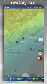
To obtain the vertical profile of a particular place simply hold your finger over any place or maps of the airport or the starting area.
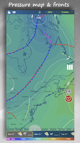
On the map, you can view the different levels you need or look at the extent of unstable areas or simply rely on the map usability.
The map shows gusts both absolute and relative, which is the difference between the basic wind and the gust and is more suitable for flying.
A distinctive Jet Stream map is intended for professionals.
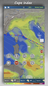
You can display clouds on maps separately or combine them for each floor. The Cape index allows you to make the most of the day while avoiding storms.
There is a map of pressure units and for the USA and its surroundings we also have a map of queues.
The bottom bar then shows schematically the basic characteristics of the day.
There are thousands of airports and start-faces, you can select them on map or from the online list.
The sun card tells you when to land, unless you are flying IFR. :)
There are 3 prediction models available and further improvements are being worked on.
The application is free and is funded by voluntary user contributions.
Do you want to know what the wind will blow at height or at the ground?
Would you like to go soaring or are you looking for proper thermals?
Do you fly paragliding, rogalo or ultralight or maybe with something bigger?
Then this application is for you.
Aero XC displays forecast information as easily as possible.
In a clear vertical profile from the ground up to a height of about 12 km, the basic parameters such as force (color scale is adapted to flying) and wind direction, gusts and temperature, humidity and dew point are displayed.
Furthermore, the power and height of instability, convection condensation level, zero isotherm and clouds of all floors on a scale. The cloud floors are color-coded and correspond to the clouds on the map.
A new feature is the indication of the inverse level, which can affect the thermal flow.
Everything can be zoomed in the range from about 2km to about 12km above sea level.
To obtain the vertical profile of a particular place simply hold your finger over any place or maps of the airport or the starting area.
On the map, you can view the different levels you need or look at the extent of unstable areas or simply rely on the map usability.
The map shows gusts both absolute and relative, which is the difference between the basic wind and the gust and is more suitable for flying.
A distinctive Jet Stream map is intended for professionals.
You can display clouds on maps separately or combine them for each floor. The Cape index allows you to make the most of the day while avoiding storms.
There is a map of pressure units and for the USA and its surroundings we also have a map of queues.
The bottom bar then shows schematically the basic characteristics of the day.
There are thousands of airports and start-faces, you can select them on map or from the online list.
The sun card tells you when to land, unless you are flying IFR. :)
There are 3 prediction models available and further improvements are being worked on.
The application is free and is funded by voluntary user contributions.
Updated on
Safety starts with understanding how developers collect and share your data. Data privacy and security practices may vary based on your use, region, and age. The developer provided this information and may update it over time.

No data shared with third parties
Learn more about how developers declare sharing

No data collected
Learn more about how developers declare collection
Ratings and reviews
4.6
635 reviews

Chris Rudisill
- Flag inappropriate
December 24, 2020
I think this is giving me a lot of great information, but I'm not sure how to read all of it (for example... Is the time strip at the bottom of the screen local time or UTC). A feature (if you are looking to add) would be the ability to enter a departure and destination and indicate a distance and have it pick locations along your route to display. It can obviously be done manually, but automation would be nice. Overall, I would just like to see better instructions and user guide.
5 people found this review helpful
Ori:Go
December 24, 2020
About.
http://wxcpro.eu/man/index.php?id=wxc-pro-apk-how-to

Barry Morse
- Flag inappropriate
- Show review history
May 11, 2022
This program is full of useful information about wind and weather conditions surface to 30K feet. The only issue I have is the symbols are not intuitive and they're not explained on the chart you're looking at. So even after years of occasional use, I still find myself needing to dig into the user manual for explanations.
4 people found this review helpful
Ori:Go
May 12, 2022
Hi and thanks for the nice reviews.
We are working on improvements, including a hint. L

David Reitter
- Flag inappropriate
August 25, 2023
advertised for flying, this app is only good for gliding I think. It starts with something basic.. adding a location. I fly an airplane that's located near Newark airport, which has good weather data, so I add EWR. why an international app doesn't take a standard ICAO Code (4 Letters) is beyond me. what does it find for EER? some "Newry Airport". what gives? the UI is unintuitive and nonstandard. As a GA pilot (and not in a glider) I want different data than this...
2 people found this review helpful
Ori:Go
September 14, 2023
The application is primarily intended for thermal flying and for those who are interested in the atmosphere. It contains several thousand airports. Airport designation according to ICAO is different in this application.
What's new
Added thermals tab.
Modified location tab and notifications.
Added export/import of favorite places.
Modified user interface.
Fixed some bugs.
Modified location tab and notifications.
Added export/import of favorite places.
Modified user interface.
Fixed some bugs.