
İBB İmarSor

50K+
Downloads

Everyone
info
About this app
ibbimars, İstanbul 1/5000 and 1/1000 Master Plan Implementation is displayed on the map application that allows questioning of development plans.
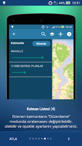
• Add layers with the desired properties can be added to the map layers.
- 1/1000 Digital Plans
- 1/5000 Digital Plans
- 1/1000 raster Plans
- 1/5000 raster Plans
- 1/1000 Plan Modifications
- 1/5000 Plan Modifications
- 1/100000 Environment Master Plan
- Administrative Boundaries Neighborhood
- Front View, Back View, and Impact Area
- Protected Areas
- Watershed Protection Harnesses
• In the Layers list can be changed as part of these layers, transparency increased or decreased and removed from the map layers added.
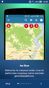
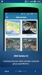
• base maps in different applications (Map Guide, orthophotos and satellite images) can be used.
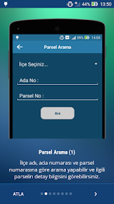
• Parcel and address search operations carried out.
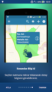
• layer in any location on the map to get information from the Location feature (doors, building, neighborhood, parcel, Plan1000 and Plan5000) can be about information.
• opinion on the application and communicate to us through feedback and suggestions.
In practice, the data can not be used in any official process is for informational purposes only.
• Add layers with the desired properties can be added to the map layers.
- 1/1000 Digital Plans
- 1/5000 Digital Plans
- 1/1000 raster Plans
- 1/5000 raster Plans
- 1/1000 Plan Modifications
- 1/5000 Plan Modifications
- 1/100000 Environment Master Plan
- Administrative Boundaries Neighborhood
- Front View, Back View, and Impact Area
- Protected Areas
- Watershed Protection Harnesses
• In the Layers list can be changed as part of these layers, transparency increased or decreased and removed from the map layers added.
• base maps in different applications (Map Guide, orthophotos and satellite images) can be used.
• Parcel and address search operations carried out.
• layer in any location on the map to get information from the Location feature (doors, building, neighborhood, parcel, Plan1000 and Plan5000) can be about information.
• opinion on the application and communicate to us through feedback and suggestions.
In practice, the data can not be used in any official process is for informational purposes only.
Updated on
Data safety
Developers can show information here about how their app collects and uses your data. Learn more about data safety

No information available
What's new
Hatalar giderildi.


