
Drone Assist - Flight Planning
3.7star
452 reviews
100K+
Downloads

Everyone
info
About this app
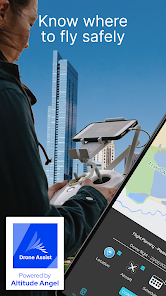
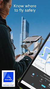
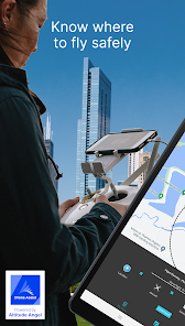
Plan and submit your commercial and recreational drone flights, check the weather, fly safely, and be in control with Drone Assist, the industry’s most trusted drone flight situational awareness source.
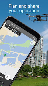
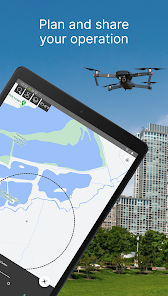
Do your pre-flight checks via the mobile app, and submit your flight plans to share your flights with other airspace users. Using Drone Assist allows you to check for any hazards preflight, and submit your flight plans, helping you stay safe and compliant when flying your drones.
Key Features
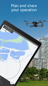
Flight Planning
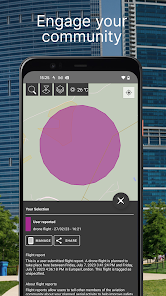
Flight Reporting
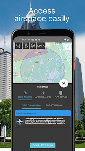
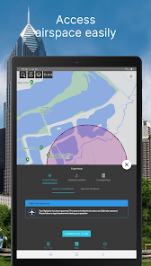
Approval access to controlled airspace
Manage Company Operations or Single Pilots
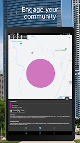
Share your flight plans on Social Channels
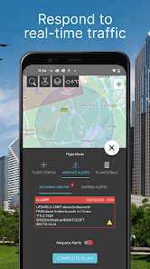
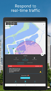
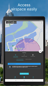
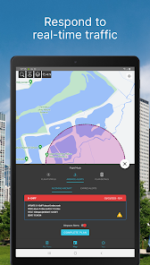
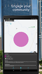
Access real-time aerial and ground data to plan and submit your flights, or choose our Fly Now feature to instantly alert other airspace users of your flight area using location-based services.
Our apps are the trusted free source for Drone flights, which also allow you to access approval services for restricted airspaces for your flight operations.
It doesn’t matter if you fly a DJI Mavic, Mini or Autel for fun, or a Parrot, Ruko, or Yuneec. Recreational use or Commercial, in a park, or doing surveys. Drone Assist is your one-stop shop to fly safely, pre-plan your flights and submit your flight plans to alert other pilots to your drone activity.
Download the Drone Assist app by Altitude Angel today to ensure you have access to the latest map data, including ground hazards, NOTAMS, and no-fly zones (NFZ). Whether you fly for fun, or professionally, Altitude Angel’s high-fidelity, accurate and authoritative data aims to help you plan your drone operations so that they can be conducted with greater respect for safety and privacy for all airspace users.
Using your location, Drone Assist supplements your normal due-diligence activities by displaying no-fly zones and ground hazards for a growing number of countries around the world, completely free of charge.
Simple and easy to use, the Drone Assist App has been designed and built with the Pilot in mind, providing you with the trusted insights you would expect from a company paving the way for Drone integration into regulated and unregulated airspace.
Our range of flight planning tools, offered both independently and as part of our wider work with ANSPs and National Aviation Authorities, make operating a drone safely as easy as possible. We encourage drone users to download the Drone Assist app to understand airspace regulations and register flights. Happy (safe) flying!
Drone Assist is the #1 drone safety app from Altitude Angel in the UK. It provides an interactive map of the sky and is used by general aviation, balloon pilots, other airspace users, and of course, drone pilots! Our map data is currently most effective in the UK, but will work in other GEOs and we are continually adding new country-specific map data. It allows you to see areas to avoid or in which extreme caution should be exercised, as well as ground hazards that may pose safety, security, or privacy risks when flying your drone.
The Drone Assist app has been built natively for optimised performance on Android.
By downloading the app you agree to the Altitude Angel Terms of Use, Privacy Policy, and Cookie Notice.
Terms of Use:
https://www.altitudeangel.com/terms-conditions
Privacy & Cookie Policy:
https://www.altitudeangel.com/privacy-policy
Social Channels
https://www.facebook.com/InternetOfFlyingThings
https://twitter.com/altitudeangel
https://www.linkedin.com/company/altitude-angel
https://www.linkedin.com/company/altitude-angel
Do your pre-flight checks via the mobile app, and submit your flight plans to share your flights with other airspace users. Using Drone Assist allows you to check for any hazards preflight, and submit your flight plans, helping you stay safe and compliant when flying your drones.
Key Features
Flight Planning
Flight Reporting
Approval access to controlled airspace
Manage Company Operations or Single Pilots
Share your flight plans on Social Channels
Access real-time aerial and ground data to plan and submit your flights, or choose our Fly Now feature to instantly alert other airspace users of your flight area using location-based services.
Our apps are the trusted free source for Drone flights, which also allow you to access approval services for restricted airspaces for your flight operations.
It doesn’t matter if you fly a DJI Mavic, Mini or Autel for fun, or a Parrot, Ruko, or Yuneec. Recreational use or Commercial, in a park, or doing surveys. Drone Assist is your one-stop shop to fly safely, pre-plan your flights and submit your flight plans to alert other pilots to your drone activity.
Download the Drone Assist app by Altitude Angel today to ensure you have access to the latest map data, including ground hazards, NOTAMS, and no-fly zones (NFZ). Whether you fly for fun, or professionally, Altitude Angel’s high-fidelity, accurate and authoritative data aims to help you plan your drone operations so that they can be conducted with greater respect for safety and privacy for all airspace users.
Using your location, Drone Assist supplements your normal due-diligence activities by displaying no-fly zones and ground hazards for a growing number of countries around the world, completely free of charge.
Simple and easy to use, the Drone Assist App has been designed and built with the Pilot in mind, providing you with the trusted insights you would expect from a company paving the way for Drone integration into regulated and unregulated airspace.
Our range of flight planning tools, offered both independently and as part of our wider work with ANSPs and National Aviation Authorities, make operating a drone safely as easy as possible. We encourage drone users to download the Drone Assist app to understand airspace regulations and register flights. Happy (safe) flying!
Drone Assist is the #1 drone safety app from Altitude Angel in the UK. It provides an interactive map of the sky and is used by general aviation, balloon pilots, other airspace users, and of course, drone pilots! Our map data is currently most effective in the UK, but will work in other GEOs and we are continually adding new country-specific map data. It allows you to see areas to avoid or in which extreme caution should be exercised, as well as ground hazards that may pose safety, security, or privacy risks when flying your drone.
The Drone Assist app has been built natively for optimised performance on Android.
By downloading the app you agree to the Altitude Angel Terms of Use, Privacy Policy, and Cookie Notice.
Terms of Use:
https://www.altitudeangel.com/terms-conditions
Privacy & Cookie Policy:
https://www.altitudeangel.com/privacy-policy
Social Channels
https://www.facebook.com/InternetOfFlyingThings
https://twitter.com/altitudeangel
https://www.linkedin.com/company/altitude-angel
https://www.linkedin.com/company/altitude-angel
Updated on
Safety starts with understanding how developers collect and share your data. Data privacy and security practices may vary based on your use, region, and age. The developer provided this information and may update it over time.


Ratings and reviews
3.7
425 reviews

David Thomson
- Flag inappropriate
- Show review history
April 12, 2024
Great app but doesn't work properly on Android. iOS works fine. You see a flight restriction on the map and press it and the details comes up at the bottom but this doesn't happen on the Android app or if it does it's very rarely and sporadically. Edit - all issues fixed in the latest update. Thanks 👍🏻
1 person found this review helpful
Altitude Angel
April 8, 2024
Hi David, Thank you for your review, we are investigating your issue to see if we can replicate and fix this for you.
If you have any further information or feedback we would love to hear it. Hello@altitudeangel.com
Fly safe!

Billy
- Flag inappropriate
- Show review history
April 11, 2024
Excellent, I had an issue selecting FRZs on the last version but it's fixed now.
Altitude Angel
April 15, 2024
Hi Billy,
Thank you for taking the time to leave a review! Glad everything is up and running for you now.
Fly Safe!

Karl Dobson
- Flag inappropriate
- Show review history
April 23, 2024
Quite slow to load FRZs. Needs to be quicker to be useful.
What's new
We're thrilled to announce the release of additional language options for Drone Assist, a significant milestone in our mission to make drone flight planning accessible to pilots worldwide. In this update, we introduce support for Dutch and Spanish languages, enhancing accessibility and user experience for our growing global community.
Fly Safe!
Fly Safe!


