
OS Maps: Explore hiking trails
In-app purchases
3.2star
18.9K reviews
1M+
Downloads

Everyone
info


About this app
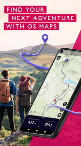
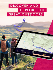
Explore the great outdoors the way you want, all while staying safe with OS Maps. Whether you want to hike, bike or run, OS Maps will guide you with amazing trails across the USA.
Want to find new places in your local neighbourhood? Or plan that next thru-hiking adventure? From breathtaking National Parks to easy walks along the coast, experience the thrill of finding a brand new trail that you never even knew existed with OS Maps. Why you’ll love using OS Maps:
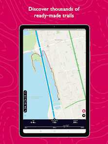
• EXPLORE NEW PLACES, CREATE NEW ADVENTURES
Plan unlimited trails with detailed, up to date maps across the country and discover that next great trail! Whether you love to hike, bike or run, there’s multiple map layers to suit any activity, including topographic and aerial maps.
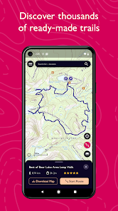
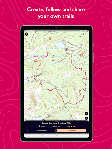
• TRAILS AT YOUR FINGERTIPS
Search for the best trails in an area as rated by fellow outdoor enthusiasts and plot your own trail to follow, share and record.
• VIEW & DOWNLOAD MAPS OFFLINE
No cell reception? No problem. Download your favorite areas to save and view offline – so you can view your maps and routes even without cell reception. Plus, you can export your favourite trails & routes to your GPX device.
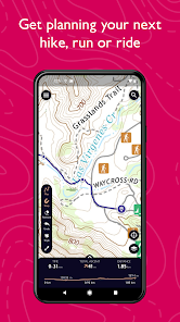
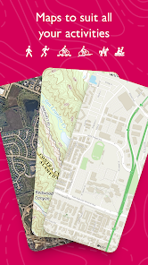
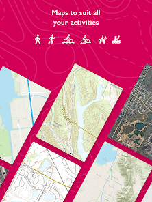
• TRAIL MAPS TO SUIT ANY ACTIVITY
Choose from multiple map layers; plan activities & find trails with detailed topographic mapping; or explore the landscape in stunning detail with aerial view. You can even see the world in 3D on desktop with 3D map layers.
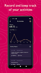
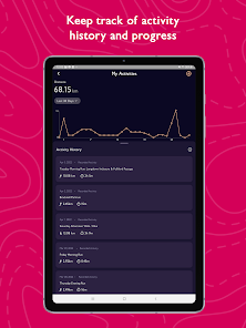
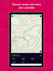
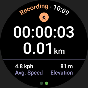
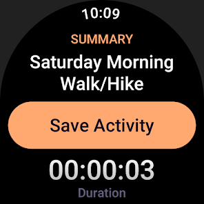
• RECORD, REVIEW & RELIVE ACTIVITIES
Use the activity tracking feature, and activity history dashboard to track each & every adventure. Look back on past activities & review your stats.
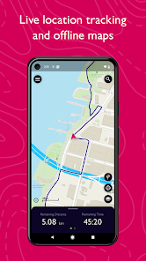
• STAY SAFE ON THE TRAIL
Live GPS location tracking and never miss a turn with off-course alerts will keep you on track. Download trails, routes and maps and share with others.
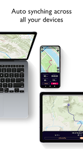
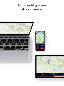
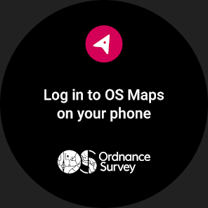
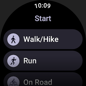
• USE ON EVERY DEVICE
Go from laptop to hilltop with ease! View, create & sync your routes & activities with a single account across multiple devices. Plan on desktop, follow & record your activities on mobile or compatible Wear OS devices.
• PLANNING MADE EASY
Use OS Maps as your off-road GPS tracker with automatic ‘snap-to-path’ making route planning easy with the shortest distance between your waypoints plotted automatically.
• UNLIMITED PRINTING
Print copies of trails and maps to take with you so you always have a backup to hand.
• USEFUL INFO
$4.99 for monthly subscriptions and $28.99 for annual subscriptions
Battery life can be dramatically decreased by using GPS constantly.
We release updates to all of our apps as we improve them, making them even more stable and adding extra features. Along the way, your feedback and comments about those apps are really important to us. If there’s an issue or something you’d like us to know, head to https://www.ordnancesurvey.co.uk/contact-us
OS Maps offers an auto-renewing monthly subscription and an auto-renewing yearly subscription to provide you with premium access to OS Maps while you maintain an active subscription. If you chose to purchase a premium subscription, your payment will be processed by Google.
Subscriptions may be managed through the Google Play App after purchase. Subscriptions on Google Play are renewed automatically unless you unsubscribe at least 24-hours before the end of the current period. Your Google account will be charged for renewal no more than 24 hours before to the end of the current period. You may cancel a subscription at any time before the end of the applicable billing period by going to your Subscriptions list on the Google Play App.
Terms and conditions: http://os.uk/termsosmaps
Privacy policy: http://os.uk/privacy
Want to find new places in your local neighbourhood? Or plan that next thru-hiking adventure? From breathtaking National Parks to easy walks along the coast, experience the thrill of finding a brand new trail that you never even knew existed with OS Maps. Why you’ll love using OS Maps:
• EXPLORE NEW PLACES, CREATE NEW ADVENTURES
Plan unlimited trails with detailed, up to date maps across the country and discover that next great trail! Whether you love to hike, bike or run, there’s multiple map layers to suit any activity, including topographic and aerial maps.
• TRAILS AT YOUR FINGERTIPS
Search for the best trails in an area as rated by fellow outdoor enthusiasts and plot your own trail to follow, share and record.
• VIEW & DOWNLOAD MAPS OFFLINE
No cell reception? No problem. Download your favorite areas to save and view offline – so you can view your maps and routes even without cell reception. Plus, you can export your favourite trails & routes to your GPX device.
• TRAIL MAPS TO SUIT ANY ACTIVITY
Choose from multiple map layers; plan activities & find trails with detailed topographic mapping; or explore the landscape in stunning detail with aerial view. You can even see the world in 3D on desktop with 3D map layers.
• RECORD, REVIEW & RELIVE ACTIVITIES
Use the activity tracking feature, and activity history dashboard to track each & every adventure. Look back on past activities & review your stats.
• STAY SAFE ON THE TRAIL
Live GPS location tracking and never miss a turn with off-course alerts will keep you on track. Download trails, routes and maps and share with others.
• USE ON EVERY DEVICE
Go from laptop to hilltop with ease! View, create & sync your routes & activities with a single account across multiple devices. Plan on desktop, follow & record your activities on mobile or compatible Wear OS devices.
• PLANNING MADE EASY
Use OS Maps as your off-road GPS tracker with automatic ‘snap-to-path’ making route planning easy with the shortest distance between your waypoints plotted automatically.
• UNLIMITED PRINTING
Print copies of trails and maps to take with you so you always have a backup to hand.
• USEFUL INFO
$4.99 for monthly subscriptions and $28.99 for annual subscriptions
Battery life can be dramatically decreased by using GPS constantly.
We release updates to all of our apps as we improve them, making them even more stable and adding extra features. Along the way, your feedback and comments about those apps are really important to us. If there’s an issue or something you’d like us to know, head to https://www.ordnancesurvey.co.uk/contact-us
OS Maps offers an auto-renewing monthly subscription and an auto-renewing yearly subscription to provide you with premium access to OS Maps while you maintain an active subscription. If you chose to purchase a premium subscription, your payment will be processed by Google.
Subscriptions may be managed through the Google Play App after purchase. Subscriptions on Google Play are renewed automatically unless you unsubscribe at least 24-hours before the end of the current period. Your Google account will be charged for renewal no more than 24 hours before to the end of the current period. You may cancel a subscription at any time before the end of the applicable billing period by going to your Subscriptions list on the Google Play App.
Terms and conditions: http://os.uk/termsosmaps
Privacy policy: http://os.uk/privacy
Updated on
Safety starts with understanding how developers collect and share your data. Data privacy and security practices may vary based on your use, region, and age. The developer provided this information and may update it over time.


Ratings and reviews
3.1
17.8K reviews

Simon Garrett
- Flag inappropriate
- Show review history
March 22, 2024
New app looks nice, but issues: Map STILL aligns True rather than Grid N. Please change. List of saved routes uses too much screen space so hard to scroll. Need an option not to show the map, or make it smaller. The icon to centre the map on current location changes the zoom. Please don't change the zoom, leave it where the user has set it. But it does look nice.
7 people found this review helpful
Ordnance Survey Ltd
January 9, 2020
Hi Simon, we're really sorry you've had trouble with the orientation change - we're aware of this issue and are currently working on the fix for this. Please accept our apologies for the inconvenience in the meantime.

Alex Bardill
- Flag inappropriate
February 11, 2023
Been using the app for months to plan and follow hikes. I still carry a paper map around in case of emergencies, but I haven't used it since installing the app. The app is just so much more convenient. One feature I would like to see is the ability to add nodes/waypoints anywhere on a route, rather than just at the end. I'm surprised to see so many people having performance issues with the app. For me it starts up instantly, has never crashed and doesn't excessively drain my battery (Pixel 5).
5 people found this review helpful
Ordnance Survey Ltd
February 16, 2023
Hi Alex, thank you for the 5-star review, and glad to hear you are enjoying OS Maps! We have route waypoints on our roadmap so watch this space!

tom.
- Flag inappropriate
- Show review history
January 3, 2024
Update: Loads of GPX file related features added to the app - great work! I'd love to see a feature to automatically create a route. It would be possible now snapping works everywhere! Select an activity (Maybe start with walk, run, cycle), select a terrain type (road or trail), select a distance, select loop or through-route > generate! This would be amazing! Leaving at 4 stars as there are some reliability issues with the app itself, it needs optimisation, but you can work around mostly.
11 people found this review helpful
Ordnance Survey Ltd
April 14, 2023
Hi Tom, thanks for your review and feedback. We've forwarded your feedback to our developers. Thank you for taking out the time to send us your suggestions! You can upload GPX files via our website at explore.osmaps.com and save the relevant route to your account to follow on your mobile device.
What's new
This latest release includes improvements to performance and introduces a map scale which can be seen in the bottom left when viewing the map.


